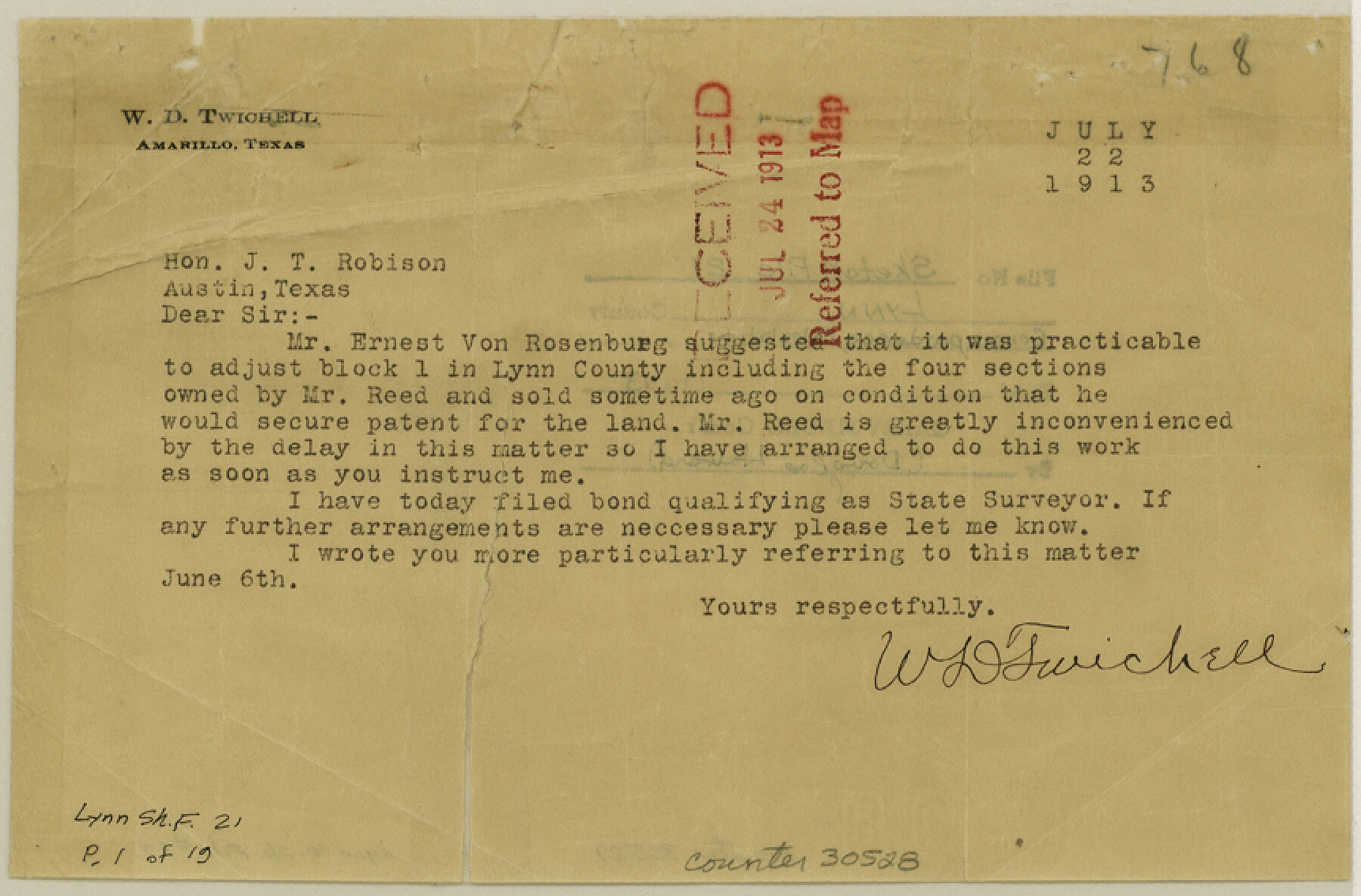
Lynn County Sketch File 21
[Correspondence and calculations from W. D. Twichell, A. L. Markoff, W. R. Standefer of Double U Company, Post, Texas, Block 1 surveys]
-
Map/Doc
30528
-
Collection
General Map Collection
-
Object Dates
1913 (Creation Date)
1913 (File Date)
7/22/1913 (Correspondence Date)
6/6/1913 (Correspondence Date)
5/26/1913 (Correspondence Date)
7/1/1913 (Correspondence Date)
7/3/1913 (Correspondence Date)
7/9/1913 (Correspondence Date)
7/10/1913 (Correspondence Date)
5/13/1878 (Survey Date)
10/18/1879 (Survey Date)
-
People and Organizations
W.D. Twichell (Surveyor/Engineer)
J. Hayes (Surveyor/Engineer)
W.R. Standefer (Surveyor/Engineer)
Jasper Hays (Surveyor/Engineer)
George Spiller (Surveyor/Engineer)
German (Surveyor/Engineer)
J.H. Kemble (Surveyor/Engineer)
-
Counties
Lynn Garza
-
Subjects
Surveying Sketch File
-
Height x Width
5.7 x 8.6 inches
14.5 x 21.8 cm
-
Medium
multi-page, multi-format
-
Features
White River
Cap Rock
Camp Branch
Guthrie Lake
Twin Lakes
Double Lakes
Double Mountain Fork
Alime River
Buffalo Trail
Yellow House Creek
Swan Lake
Part of: General Map Collection
Lee County Working Sketch 15

Print $20.00
- Digital $50.00
Lee County Working Sketch 15
1981
Size 18.4 x 14.0 inches
Map/Doc 70394
Andrews County Working Sketch 17

Print $20.00
- Digital $50.00
Andrews County Working Sketch 17
1963
Size 30.7 x 27.1 inches
Map/Doc 67063
San Augustine County Working Sketch 17

Print $20.00
- Digital $50.00
San Augustine County Working Sketch 17
1963
Size 20.3 x 21.5 inches
Map/Doc 63705
Flight Mission No. DAG-17K, Frame 78, Matagorda County

Print $20.00
- Digital $50.00
Flight Mission No. DAG-17K, Frame 78, Matagorda County
1952
Size 18.7 x 22.4 inches
Map/Doc 86337
Hutchinson County Rolled Sketch 40

Print $20.00
- Digital $50.00
Hutchinson County Rolled Sketch 40
1981
Size 26.8 x 37.6 inches
Map/Doc 6301
A Map of Part of Matagorda Peninsula, State of Texas

Print $40.00
- Digital $50.00
A Map of Part of Matagorda Peninsula, State of Texas
1856
Size 34.4 x 54.2 inches
Map/Doc 69980
Limestone County Sketch File 8

Print $20.00
- Digital $50.00
Limestone County Sketch File 8
1869
Size 15.6 x 23.7 inches
Map/Doc 12002
Stephens County Working Sketch 25

Print $20.00
- Digital $50.00
Stephens County Working Sketch 25
1976
Size 37.4 x 32.3 inches
Map/Doc 63968
Terrell County Rolled Sketch 25

Print $20.00
- Digital $50.00
Terrell County Rolled Sketch 25
1911
Size 15.7 x 22.7 inches
Map/Doc 7932
Palo Pinto County Sketch File 29

Print $40.00
- Digital $50.00
Palo Pinto County Sketch File 29
1874
Size 12.8 x 16.0 inches
Map/Doc 33419
Starr County Sketch File 47

Print $6.00
- Digital $50.00
Starr County Sketch File 47
1949
Size 11.2 x 8.8 inches
Map/Doc 37002
Bosque County

Print $40.00
- Digital $50.00
Bosque County
1945
Size 48.3 x 38.0 inches
Map/Doc 73083
You may also like
Ellis County Boundary File 6

Print $22.00
- Digital $50.00
Ellis County Boundary File 6
Size 8.6 x 6.0 inches
Map/Doc 52992
Pecos County Rolled Sketch DK3

Print $20.00
- Digital $50.00
Pecos County Rolled Sketch DK3
1938
Size 35.3 x 42.3 inches
Map/Doc 9715
Henderson County Rolled Sketch 11

Print $20.00
- Digital $50.00
Henderson County Rolled Sketch 11
1915
Size 29.2 x 42.9 inches
Map/Doc 76149
Coryell County Working Sketch 32

Print $20.00
- Digital $50.00
Coryell County Working Sketch 32
2022
Size 25.3 x 36.9 inches
Map/Doc 96966
Brazoria County Working Sketch 42

Print $20.00
- Digital $50.00
Brazoria County Working Sketch 42
1984
Size 43.5 x 47.1 inches
Map/Doc 67527
Frio County Rolled Sketch HM2

Print $20.00
- Digital $50.00
Frio County Rolled Sketch HM2
1935
Size 41.3 x 30.6 inches
Map/Doc 8899
Crockett County Working Sketch 94

Print $20.00
- Digital $50.00
Crockett County Working Sketch 94
1979
Size 43.1 x 28.7 inches
Map/Doc 68427
Gonzales County

Print $40.00
- Digital $50.00
Gonzales County
1986
Size 42.2 x 55.8 inches
Map/Doc 95510
Sketch No. 2 Showing Land Ties with Houston & Texas Central Rail Road through Harris County, Texas

Print $20.00
- Digital $50.00
Sketch No. 2 Showing Land Ties with Houston & Texas Central Rail Road through Harris County, Texas
1880
Size 8.5 x 26.9 inches
Map/Doc 64496
Jeff Davis Co.

Print $40.00
- Digital $50.00
Jeff Davis Co.
1915
Size 26.7 x 49.4 inches
Map/Doc 3720
Washington County

Print $20.00
- Digital $50.00
Washington County
1920
Size 32.5 x 47.2 inches
Map/Doc 16918
La Salle County Rolled Sketch 32

Print $20.00
- Digital $50.00
La Salle County Rolled Sketch 32
2012
Size 24.0 x 36.0 inches
Map/Doc 93286