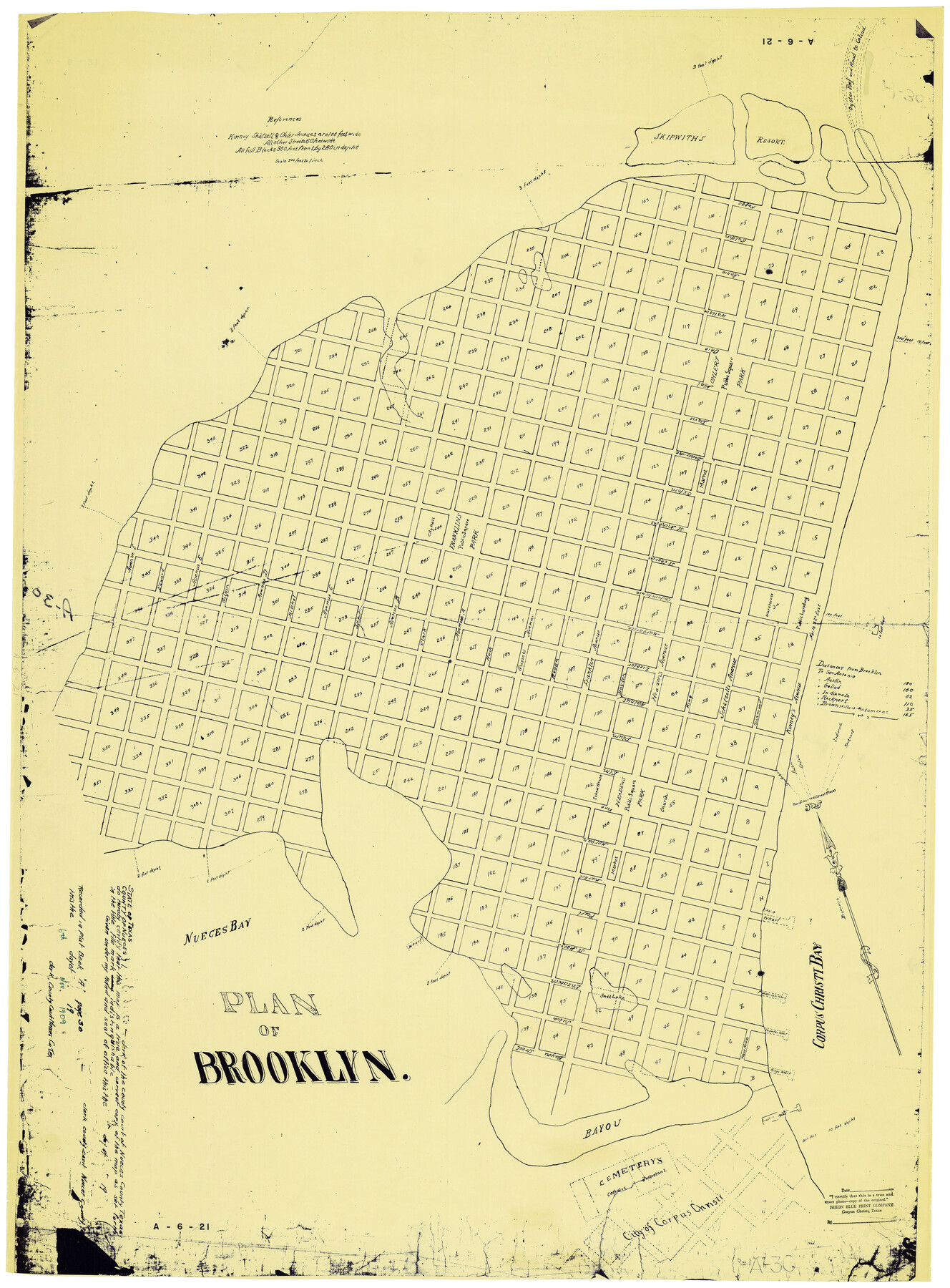
Plan of Brooklyn
A-6-21
-
Map/Doc
2192
-
Collection
General Map Collection
-
Object Dates
11/6/1909 (Creation Date)
-
People and Organizations
Nixon Blueprint Company (Printer)
-
Counties
Nueces
-
Subjects
City
-
Height x Width
42.7 x 31.5 inches
108.5 x 80.0 cm
-
Medium
blueprint/diazo
-
Scale
1" = 300 ft.
-
Features
Kings Wharf
Brooklyn
[Road to] Rockport
[Road to] Indianola
[Road to] Goliad
[Road to] Austin
[Road to] San Antonio
Corpus Christi
Protestant Cemetery
Catholic Cemetery
Oyster Reef
Skipwiths Wharf
Salt Lake
Doddridges Wharf
Corpus Christi Bay
Nueces Bay
Headens Park
Franklin's Park
Ohler's Park
Road to Goliad
Part of: General Map Collection
Jack County Sketch File 10a

Print $4.00
- Digital $50.00
Jack County Sketch File 10a
1858
Size 13.8 x 8.3 inches
Map/Doc 27529

Flight Mission No. DQN-2K, Frame 28, Calhoun County

Print $20.00
- Digital $50.00
Flight Mission No. DQN-2K, Frame 28, Calhoun County
1953
Size 18.6 x 22.2 inches
Map/Doc 84235
Galveston County NRC Article 33.136 Sketch 81

Print $202.00
- Digital $50.00
Galveston County NRC Article 33.136 Sketch 81
2015
Size 34.0 x 22.0 inches
Map/Doc 94976
Ward County Working Sketch 17

Print $20.00
- Digital $50.00
Ward County Working Sketch 17
1948
Size 30.1 x 32.5 inches
Map/Doc 72323
Harbor Pass and Bar at Brazos Santiago, Texas

Print $20.00
- Digital $50.00
Harbor Pass and Bar at Brazos Santiago, Texas
1879
Size 18.1 x 27.4 inches
Map/Doc 73002
Flight Mission No. CGI-1N, Frame 176, Cameron County

Print $20.00
- Digital $50.00
Flight Mission No. CGI-1N, Frame 176, Cameron County
1955
Size 18.5 x 22.2 inches
Map/Doc 84511
Brazoria County NRC Article 33.136 Sketch 29

Print $24.00
Brazoria County NRC Article 33.136 Sketch 29
2025
Map/Doc 97474
Van Zandt County Sketch File 19a

Print $4.00
- Digital $50.00
Van Zandt County Sketch File 19a
1858
Size 7.1 x 8.0 inches
Map/Doc 39424
Sketch showing Mineral Leases in Nueces Bay

Print $20.00
- Digital $50.00
Sketch showing Mineral Leases in Nueces Bay
1942
Size 14.3 x 24.3 inches
Map/Doc 3019

Aransas County Rolled Sketch 15C

Print $3.00
- Digital $50.00
Aransas County Rolled Sketch 15C
Size 10.2 x 17.6 inches
Map/Doc 76067
You may also like
Current Miscellaneous File 32

Print $12.00
- Digital $50.00
Current Miscellaneous File 32
Size 11.0 x 8.7 inches
Map/Doc 73933
Northern Part of Laguna Madre

Print $20.00
- Digital $50.00
Northern Part of Laguna Madre
1959
Size 44.5 x 35.1 inches
Map/Doc 73525
New Commercial Map of Texas

Print $20.00
New Commercial Map of Texas
1900
Size 28.1 x 34.0 inches
Map/Doc 76199
Duval County Working Sketch 12

Print $20.00
- Digital $50.00
Duval County Working Sketch 12
1937
Size 22.1 x 27.8 inches
Map/Doc 68725
Swisher County Sketch File 10

Print $6.00
- Digital $50.00
Swisher County Sketch File 10
1936
Size 11.0 x 15.9 inches
Map/Doc 37631
Terrell County Working Sketch 73

Print $20.00
- Digital $50.00
Terrell County Working Sketch 73
1980
Size 29.0 x 47.5 inches
Map/Doc 69594
Louisiana and Texas Intracoastal Waterway, Section 7, Galveston Bay to Brazos River and Section 8, Brazos River to Matagorda Bay

Print $20.00
- Digital $50.00
Louisiana and Texas Intracoastal Waterway, Section 7, Galveston Bay to Brazos River and Section 8, Brazos River to Matagorda Bay
1929
Size 30.8 x 43.0 inches
Map/Doc 61841
Crockett County Sketch File 94

Print $6.00
- Digital $50.00
Crockett County Sketch File 94
1940
Size 9.2 x 12.3 inches
Map/Doc 19950
Rio Grande, Raymondville Sheet

Print $20.00
- Digital $50.00
Rio Grande, Raymondville Sheet
1937
Size 37.3 x 37.9 inches
Map/Doc 65110
Dimmit County Rolled Sketch 11

Print $20.00
- Digital $50.00
Dimmit County Rolled Sketch 11
1942
Size 21.8 x 28.9 inches
Map/Doc 5720
Presidio County Rolled Sketch 99

Print $20.00
- Digital $50.00
Presidio County Rolled Sketch 99
Size 38.7 x 33.6 inches
Map/Doc 9784
Bell County Sketch File 36

Print $12.00
- Digital $50.00
Bell County Sketch File 36
1839
Size 6.8 x 8.4 inches
Map/Doc 14457