Burleson County Sketch File 3
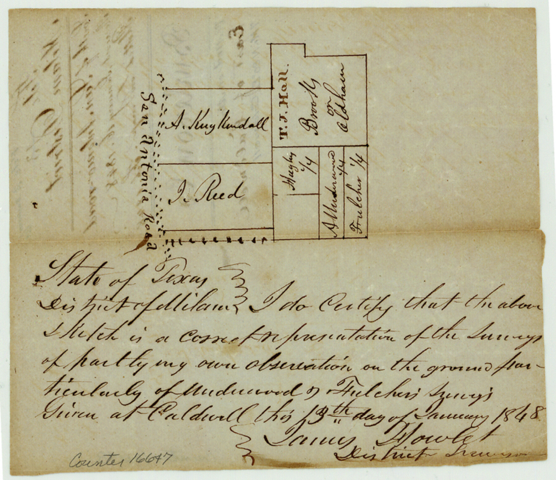
[Sketch of A. Kuykendall and J. Reed surveys along San Antonio Road and area just to the southeast]
-
Map/Doc
16647
-
Collection
General Map Collection
-
Object Dates
1848/1/16 (File Date)
1848/1/13 (Creation Date)
-
People and Organizations
James Howlet (Surveyor/Engineer)
-
Counties
Burleson
-
Subjects
Surveying Sketch File
-
Height x Width
6.4 x 7.4 inches
16.3 x 18.8 cm
-
Medium
paper, manuscript
-
Features
San Antonio Road
Part of: General Map Collection
Lynn County Boundary File 7a

Print $8.00
- Digital $50.00
Lynn County Boundary File 7a
Size 14.3 x 8.8 inches
Map/Doc 56647
Flight Mission No. BRA-16M, Frame 92, Jefferson County

Print $20.00
- Digital $50.00
Flight Mission No. BRA-16M, Frame 92, Jefferson County
1953
Size 18.6 x 22.3 inches
Map/Doc 85704
Refugio County Sketch File 20

Print $8.00
- Digital $50.00
Refugio County Sketch File 20
Size 14.4 x 8.8 inches
Map/Doc 35276
Van Zandt County Sketch File 15b

Print $4.00
- Digital $50.00
Van Zandt County Sketch File 15b
1858
Size 12.2 x 7.7 inches
Map/Doc 39408
Brazoria County Sketch File 13

Print $40.00
- Digital $50.00
Brazoria County Sketch File 13
Size 23.8 x 23.0 inches
Map/Doc 10950
Crane County Working Sketch 22

Print $20.00
- Digital $50.00
Crane County Working Sketch 22
1961
Size 44.7 x 43.9 inches
Map/Doc 68299
Knox County Working Sketch 12

Print $20.00
- Digital $50.00
Knox County Working Sketch 12
1951
Size 26.2 x 23.5 inches
Map/Doc 70254
Calhoun County Rolled Sketch 30

Print $20.00
- Digital $50.00
Calhoun County Rolled Sketch 30
1974
Size 18.5 x 27.6 inches
Map/Doc 5489
Controlled Mosaic by Jack Amman Photogrammetric Engineers, Inc - Sheet 24

Print $20.00
- Digital $50.00
Controlled Mosaic by Jack Amman Photogrammetric Engineers, Inc - Sheet 24
1954
Size 20.0 x 24.0 inches
Map/Doc 83475
King County Working Sketch 14

Print $20.00
- Digital $50.00
King County Working Sketch 14
1979
Size 27.7 x 32.5 inches
Map/Doc 70178
Montgomery County Rolled Sketch 35

Print $40.00
- Digital $50.00
Montgomery County Rolled Sketch 35
Size 36.7 x 51.3 inches
Map/Doc 9543
Mills County Working Sketch 25

Print $20.00
- Digital $50.00
Mills County Working Sketch 25
1988
Size 22.0 x 25.1 inches
Map/Doc 71055
You may also like
Briscoe County Sketch File C

Print $40.00
- Digital $50.00
Briscoe County Sketch File C
1900
Size 20.4 x 35.6 inches
Map/Doc 11000
Polk County Rolled Sketch FD

Print $40.00
- Digital $50.00
Polk County Rolled Sketch FD
Size 99.8 x 38.2 inches
Map/Doc 9754
Calhoun County Rolled Sketch 30

Print $20.00
- Digital $50.00
Calhoun County Rolled Sketch 30
1974
Size 18.5 x 27.6 inches
Map/Doc 5490
[B. S. & F. Block 9 and surrounding area]
![93070, [B. S. & F. Block 9 and surrounding area], Twichell Survey Records](https://historictexasmaps.com/wmedia_w700/maps/93070-1.tif.jpg)
Print $20.00
- Digital $50.00
[B. S. & F. Block 9 and surrounding area]
Size 18.3 x 26.1 inches
Map/Doc 93070
Jeff Davis County Sketch File 18a

Print $14.00
- Digital $50.00
Jeff Davis County Sketch File 18a
Size 9.3 x 6.0 inches
Map/Doc 27966
Loving County Rolled Sketch 1

Print $40.00
- Digital $50.00
Loving County Rolled Sketch 1
Size 42.5 x 79.5 inches
Map/Doc 9460
Harris County Rolled Sketch 30

Print $20.00
- Digital $50.00
Harris County Rolled Sketch 30
1889
Size 30.4 x 35.1 inches
Map/Doc 6096
Collingsworth County Sketch File 9

Print $20.00
- Digital $50.00
Collingsworth County Sketch File 9
Size 16.5 x 12.0 inches
Map/Doc 11133
Corpus Christi Bay

Print $20.00
- Digital $50.00
Corpus Christi Bay
1975
Size 36.1 x 47.5 inches
Map/Doc 73475
Eastland County Boundary File 26a

Print $32.00
- Digital $50.00
Eastland County Boundary File 26a
Size 12.7 x 8.1 inches
Map/Doc 52813
Val Verde County Sketch File Z9

Print $20.00
- Digital $50.00
Val Verde County Sketch File Z9
1891
Size 15.9 x 24.8 inches
Map/Doc 12554
Flight Mission No. DAG-17K, Frame 120, Matagorda County

Print $20.00
- Digital $50.00
Flight Mission No. DAG-17K, Frame 120, Matagorda County
1952
Size 18.6 x 22.4 inches
Map/Doc 86340