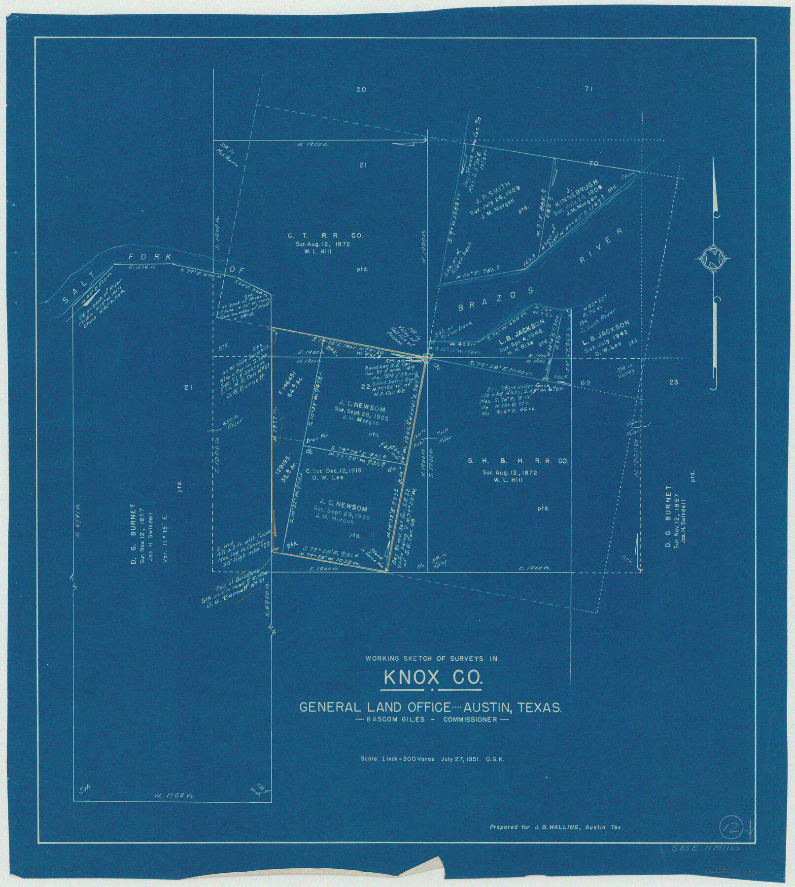
Knox County Working Sketch 12
-
Map/Doc
70254
-
Collection
General Map Collection
-
Object Dates
7/27/1951 (Creation Date)
-
People and Organizations
Otto G. Kurio (Draftsman)
-
Counties
Knox
-
Subjects
Surveying Working Sketch
-
Height x Width
26.2 x 23.5 inches
66.6 x 59.7 cm
-
Scale
1" = 300 varas
Part of: General Map Collection
Real County Working Sketch 88

Print $20.00
- Digital $50.00
Real County Working Sketch 88
1989
Size 23.9 x 27.0 inches
Map/Doc 71980
Culberson County Rolled Sketch 39

Print $20.00
- Digital $50.00
Culberson County Rolled Sketch 39
Size 25.6 x 19.3 inches
Map/Doc 5783
Hood County Working Sketch 9

Print $20.00
- Digital $50.00
Hood County Working Sketch 9
1972
Size 28.0 x 31.7 inches
Map/Doc 66203
Amistad International Reservoir on Rio Grande 95

Print $20.00
- Digital $50.00
Amistad International Reservoir on Rio Grande 95
1950
Size 28.5 x 40.1 inches
Map/Doc 75525
Travis County Rolled Sketch 11

Print $20.00
- Digital $50.00
Travis County Rolled Sketch 11
Size 23.3 x 37.9 inches
Map/Doc 8014
Presidio County Sketch File 79

Print $20.00
- Digital $50.00
Presidio County Sketch File 79
1949
Size 17.0 x 30.8 inches
Map/Doc 11722
Reagan County Rolled Sketch 35

Print $20.00
- Digital $50.00
Reagan County Rolled Sketch 35
Size 26.4 x 38.4 inches
Map/Doc 7448
San Jacinto County Sketch File O

Print $4.00
San Jacinto County Sketch File O
Size 7.8 x 8.1 inches
Map/Doc 35696
Titus County Working Sketch 2

Print $20.00
- Digital $50.00
Titus County Working Sketch 2
Size 23.6 x 25.3 inches
Map/Doc 69363
Jefferson County Working Sketch 32

Print $40.00
- Digital $50.00
Jefferson County Working Sketch 32
1981
Size 68.9 x 36.0 inches
Map/Doc 66576
Jack County Sketch File 10

Print $4.00
- Digital $50.00
Jack County Sketch File 10
1857
Size 12.4 x 8.3 inches
Map/Doc 27527
Hale County Boundary File 4

Print $40.00
- Digital $50.00
Hale County Boundary File 4
Size 8.8 x 4.2 inches
Map/Doc 54048
You may also like
Coast Chart No. 210 Aransas Pass and Corpus Christi Bay with the coast to latitude 27° 12' Texas

Print $20.00
- Digital $50.00
Coast Chart No. 210 Aransas Pass and Corpus Christi Bay with the coast to latitude 27° 12' Texas
1913
Size 27.9 x 18.3 inches
Map/Doc 72805
Jack County Sketch File 12

Print $9.00
- Digital $50.00
Jack County Sketch File 12
Size 5.6 x 8.3 inches
Map/Doc 27533
Lynn County Rolled Sketch WR

Print $20.00
- Digital $50.00
Lynn County Rolled Sketch WR
Size 14.7 x 23.8 inches
Map/Doc 6656
Victoria County Sketch File 12

Print $4.00
- Digital $50.00
Victoria County Sketch File 12
1978
Size 11.4 x 8.9 inches
Map/Doc 39540
Swisher County Sketch File 1b

Print $8.00
- Digital $50.00
Swisher County Sketch File 1b
1884
Size 12.8 x 8.2 inches
Map/Doc 37570
The Republic County of Bexar. December 31, 1838

Print $20.00
The Republic County of Bexar. December 31, 1838
2020
Size 24.6 x 21.6 inches
Map/Doc 96096
Duval County Rolled Sketch 41

Print $20.00
- Digital $50.00
Duval County Rolled Sketch 41
1966
Size 23.3 x 21.1 inches
Map/Doc 5758

Hudspeth County Rolled Sketch 44

Print $20.00
- Digital $50.00
Hudspeth County Rolled Sketch 44
1951
Size 12.1 x 11.5 inches
Map/Doc 9217
[Sketch for Mineral Applications 26885-6 - Reagan and Crockett Cos., W. H. Bland]
![2854, [Sketch for Mineral Applications 26885-6 - Reagan and Crockett Cos., W. H. Bland], General Map Collection](https://historictexasmaps.com/wmedia_w700/maps/2854.tif.jpg)
Print $20.00
- Digital $50.00
[Sketch for Mineral Applications 26885-6 - Reagan and Crockett Cos., W. H. Bland]
1932
Size 41.5 x 36.6 inches
Map/Doc 2854
Galveston County Sketch File 73f

Print $20.00
- Digital $50.00
Galveston County Sketch File 73f
Size 33.1 x 40.3 inches
Map/Doc 10459
Uvalde County Working Sketch 56

Print $20.00
- Digital $50.00
Uvalde County Working Sketch 56
1985
Size 44.8 x 40.6 inches
Map/Doc 72126