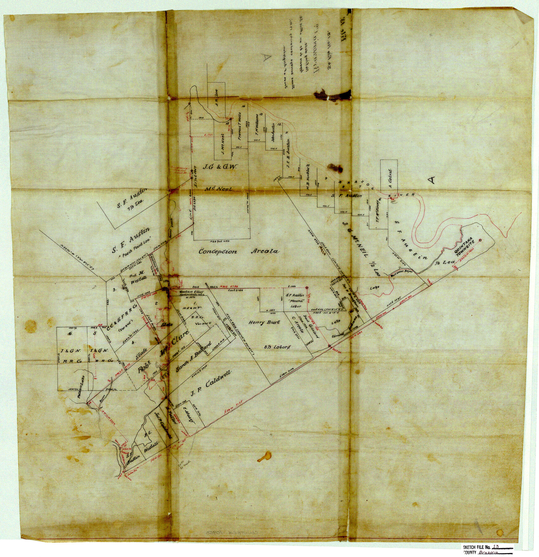
Brazoria County Sketch File 13
[Sketch of area centering around the Concepcion Areola survey south of the Brazos River]
-
Map/Doc
10950
-
Collection
General Map Collection
-
Counties
Brazoria
-
Subjects
Surveying Sketch File
-
Height x Width
23.8 x 23.0 inches
60.5 x 58.4 cm
-
Medium
linen, manuscript
-
Features
Jones Creek
Brazos River
Quintana
West Union Bayou
Pelican Lake
Part of: General Map Collection
Limestone County

Print $40.00
- Digital $50.00
Limestone County
1922
Size 48.1 x 35.4 inches
Map/Doc 16880
Trace of a copy of the map captured at the battle of Resaca de la Palma

Print $20.00
- Digital $50.00
Trace of a copy of the map captured at the battle of Resaca de la Palma
Size 18.3 x 27.3 inches
Map/Doc 73054
Presidio County Working Sketch 148

Print $20.00
- Digital $50.00
Presidio County Working Sketch 148
1991
Size 31.7 x 42.7 inches
Map/Doc 71826
Pecos County Working Sketch 68

Print $20.00
- Digital $50.00
Pecos County Working Sketch 68
1955
Size 41.4 x 24.0 inches
Map/Doc 71540
Fayette County Working Sketch 1

Print $20.00
- Digital $50.00
Fayette County Working Sketch 1
1949
Size 25.4 x 18.0 inches
Map/Doc 69165
Harris County Working Sketch 21

Print $20.00
- Digital $50.00
Harris County Working Sketch 21
Size 14.1 x 22.6 inches
Map/Doc 65913
[10th St and 29th St Groins - Galveston]
![73621, [10th St and 29th St Groins - Galveston], General Map Collection](https://historictexasmaps.com/wmedia_w700/maps/73621-1.tif.jpg)
Print $6.00
- Digital $50.00
[10th St and 29th St Groins - Galveston]
1983
Size 25.6 x 35.2 inches
Map/Doc 73621
Flight Mission No. CGI-3N, Frame 111, Cameron County

Print $20.00
- Digital $50.00
Flight Mission No. CGI-3N, Frame 111, Cameron County
1954
Size 18.6 x 22.2 inches
Map/Doc 84591
Jim Hogg County Working Sketch 9

Print $20.00
- Digital $50.00
Jim Hogg County Working Sketch 9
1973
Size 14.3 x 11.2 inches
Map/Doc 66595
Walker County Working Sketch 11

Print $20.00
- Digital $50.00
Walker County Working Sketch 11
1935
Size 28.2 x 38.8 inches
Map/Doc 72291
[San Antonio & Aransas Pass Ry. from Lockhart to Caldwell-Gonzales County line]
![64259, [San Antonio & Aransas Pass Ry. from Lockhart to Caldwell-Gonzales County line], General Map Collection](https://historictexasmaps.com/wmedia_w700/maps/64259.tif.jpg)
Print $40.00
- Digital $50.00
[San Antonio & Aransas Pass Ry. from Lockhart to Caldwell-Gonzales County line]
1895
Size 53.6 x 15.1 inches
Map/Doc 64259
Upton County Working Sketch 14

Print $20.00
- Digital $50.00
Upton County Working Sketch 14
1938
Size 14.9 x 20.9 inches
Map/Doc 69510
You may also like
Hansford County

Print $20.00
- Digital $50.00
Hansford County
1902
Size 42.3 x 37.5 inches
Map/Doc 4969
Flight Mission No. BQY-15M, Frame 12, Harris County

Print $20.00
- Digital $50.00
Flight Mission No. BQY-15M, Frame 12, Harris County
1953
Size 18.7 x 22.4 inches
Map/Doc 85310
Milam County Working Sketch 9

Print $20.00
- Digital $50.00
Milam County Working Sketch 9
1976
Size 27.2 x 22.7 inches
Map/Doc 71024
Flight Mission No. CUG-3P, Frame 37, Kleberg County

Print $20.00
- Digital $50.00
Flight Mission No. CUG-3P, Frame 37, Kleberg County
1956
Size 18.5 x 22.2 inches
Map/Doc 86242

Harris County Working Sketch 92

Print $40.00
- Digital $50.00
Harris County Working Sketch 92
1974
Size 33.8 x 55.5 inches
Map/Doc 69648
Oldham County Working Sketch 2

Print $20.00
- Digital $50.00
Oldham County Working Sketch 2
1906
Size 16.1 x 15.1 inches
Map/Doc 71324
Map of Brassos [sic] & Bosque Surveys
![146, Map of Brassos [sic] & Bosque Surveys, General Map Collection](https://historictexasmaps.com/wmedia_w700/maps/146.tif.jpg)
Print $20.00
- Digital $50.00
Map of Brassos [sic] & Bosque Surveys
1841
Size 27.7 x 18.9 inches
Map/Doc 146
Menard County Sketch File 23

Print $20.00
- Digital $50.00
Menard County Sketch File 23
1927
Size 21.2 x 31.1 inches
Map/Doc 12076
Upshur County Sketch File 15

Print $20.00
- Digital $50.00
Upshur County Sketch File 15
1934
Size 20.7 x 31.2 inches
Map/Doc 12505
Potter County Boundary File 6a

Print $20.00
- Digital $50.00
Potter County Boundary File 6a
Size 43.8 x 15.6 inches
Map/Doc 58039
[Scripture Addition to the City of Denton]
![90586, [Scripture Addition to the City of Denton], Twichell Survey Records](https://historictexasmaps.com/wmedia_w700/maps/90586-1.tif.jpg)
Print $20.00
- Digital $50.00
[Scripture Addition to the City of Denton]
Size 35.4 x 31.4 inches
Map/Doc 90586