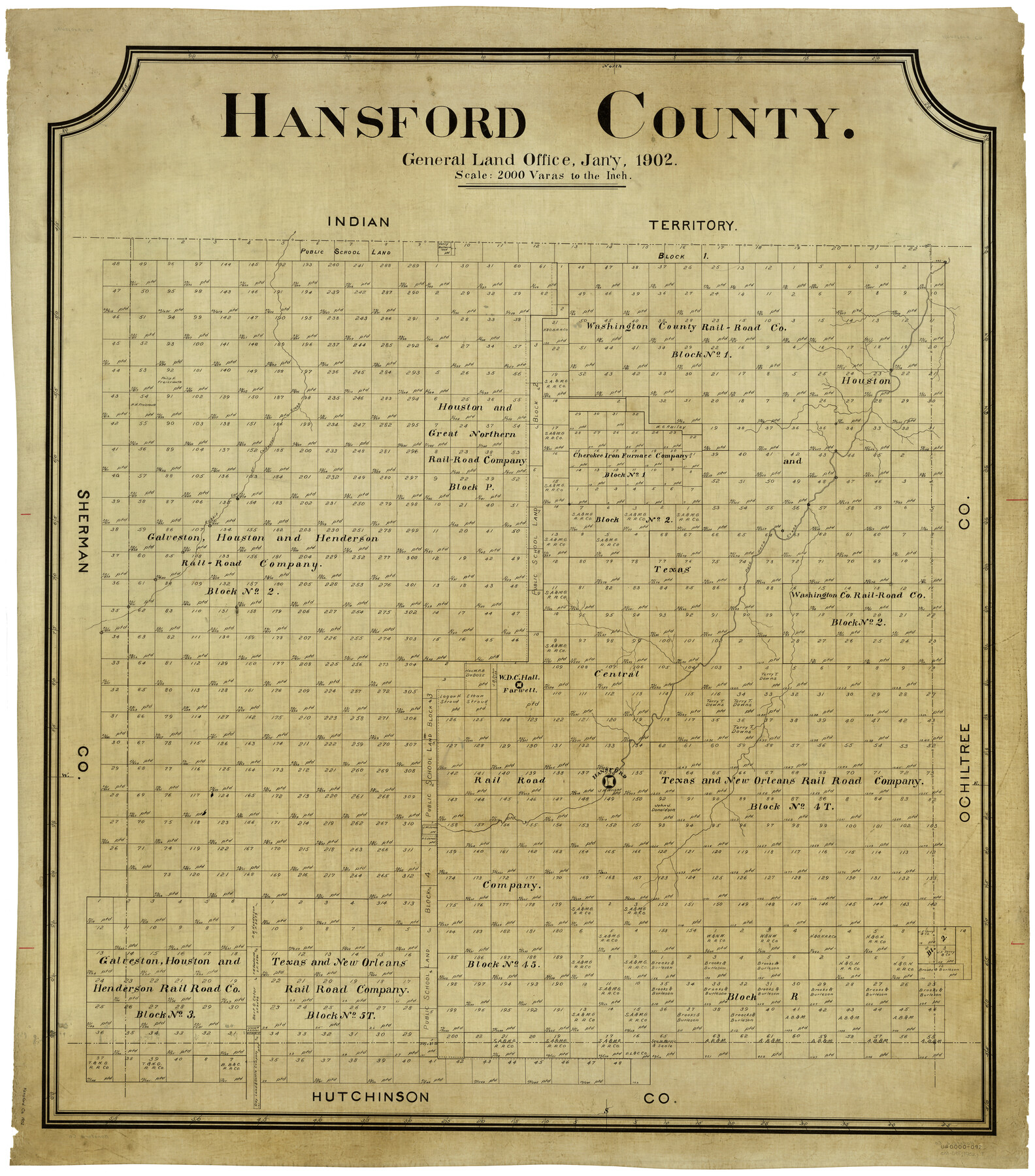
Hansford County
-
Map/Doc
4969
-
Collection
General Map Collection
-
Object Dates
1/1902 (Creation Date)
-
Counties
Hansford
-
Subjects
County
-
Height x Width
42.3 x 37.5 inches
107.4 x 95.3 cm
Part of: General Map Collection
Coke County Working Sketch 16

Print $20.00
- Digital $50.00
Coke County Working Sketch 16
1948
Size 23.4 x 24.5 inches
Map/Doc 68053
Ward County Working Sketch 40

Print $20.00
- Digital $50.00
Ward County Working Sketch 40
1969
Size 24.4 x 45.7 inches
Map/Doc 72346
Morris County Rolled Sketch 2A

Print $20.00
- Digital $50.00
Morris County Rolled Sketch 2A
Size 36.0 x 25.0 inches
Map/Doc 10236
Harris County Rolled Sketch 80

Print $20.00
- Digital $50.00
Harris County Rolled Sketch 80
1958
Size 31.1 x 31.0 inches
Map/Doc 6116
Maps of Gulf Intracoastal Waterway, Texas - Sabine River to the Rio Grande and connecting waterways including ship channels

Print $20.00
- Digital $50.00
Maps of Gulf Intracoastal Waterway, Texas - Sabine River to the Rio Grande and connecting waterways including ship channels
1966
Size 14.6 x 22.2 inches
Map/Doc 61939

Wharton County Rolled Sketch 3

Print $20.00
- Digital $50.00
Wharton County Rolled Sketch 3
Size 28.9 x 31.4 inches
Map/Doc 8228
Flight Mission No. DAH-10M, Frame 43, Orange County

Print $20.00
- Digital $50.00
Flight Mission No. DAH-10M, Frame 43, Orange County
1953
Size 18.6 x 22.6 inches
Map/Doc 86878
A New Map of the Whole Continent of America. Divided into North and South and West Indies, wherein are exactly decribed the United States of North America as well as the Several European Possessions according to the Preliminaries of Peace…

Print $40.00
- Digital $50.00
A New Map of the Whole Continent of America. Divided into North and South and West Indies, wherein are exactly decribed the United States of North America as well as the Several European Possessions according to the Preliminaries of Peace…
Size 42.8 x 48.8 inches
Map/Doc 95137
Flight Mission No. BQY-4M, Frame 124, Harris County

Print $20.00
- Digital $50.00
Flight Mission No. BQY-4M, Frame 124, Harris County
1953
Size 18.7 x 22.4 inches
Map/Doc 85292
Dimmit County Sketch File 1

Print $42.00
- Digital $50.00
Dimmit County Sketch File 1
1851
Size 8.8 x 7.5 inches
Map/Doc 21050
Right of Way & Track Map, San Antonio & Aransas Pass Railway Co.

Print $40.00
- Digital $50.00
Right of Way & Track Map, San Antonio & Aransas Pass Railway Co.
1919
Size 25.0 x 56.7 inches
Map/Doc 64215
You may also like
Hemphill County Working Sketch 9

Print $20.00
- Digital $50.00
Hemphill County Working Sketch 9
1965
Size 23.0 x 32.8 inches
Map/Doc 66104
Hardin County Working Sketch 18

Print $20.00
- Digital $50.00
Hardin County Working Sketch 18
1944
Size 18.7 x 22.0 inches
Map/Doc 63416
Sterling County Boundary File 1

Print $56.00
- Digital $50.00
Sterling County Boundary File 1
Size 9.0 x 8.7 inches
Map/Doc 58919
Concho County Working Sketch 6

Print $20.00
- Digital $50.00
Concho County Working Sketch 6
1948
Size 47.3 x 43.2 inches
Map/Doc 68188
Railroad Track Map, T&PRRCo., Culberson County, Texas

Print $4.00
- Digital $50.00
Railroad Track Map, T&PRRCo., Culberson County, Texas
1910
Size 11.7 x 18.6 inches
Map/Doc 62829
Crosby County Sketch File 17

Print $4.00
- Digital $50.00
Crosby County Sketch File 17
1907
Size 4.2 x 8.9 inches
Map/Doc 20069
Wood County Sketch File 2

Print $4.00
- Digital $50.00
Wood County Sketch File 2
1848
Size 8.3 x 6.4 inches
Map/Doc 40631

The Judicial District/County of Menard. Abolished, Spring 1842

Print $20.00
The Judicial District/County of Menard. Abolished, Spring 1842
2020
Size 22.4 x 21.7 inches
Map/Doc 96337
Bailey County Working Sketch 2

Print $20.00
- Digital $50.00
Bailey County Working Sketch 2
1920
Size 17.8 x 16.2 inches
Map/Doc 67589
[Mrs. Adair Resurvey]
![89976, [Mrs. Adair Resurvey], Twichell Survey Records](https://historictexasmaps.com/wmedia_w700/maps/89976-1.tif.jpg)
Print $20.00
- Digital $50.00
[Mrs. Adair Resurvey]
1918
Size 36.5 x 27.4 inches
Map/Doc 89976
Brewster County Rolled Sketch 59D

Print $20.00
- Digital $50.00
Brewster County Rolled Sketch 59D
Size 33.3 x 47.3 inches
Map/Doc 5231