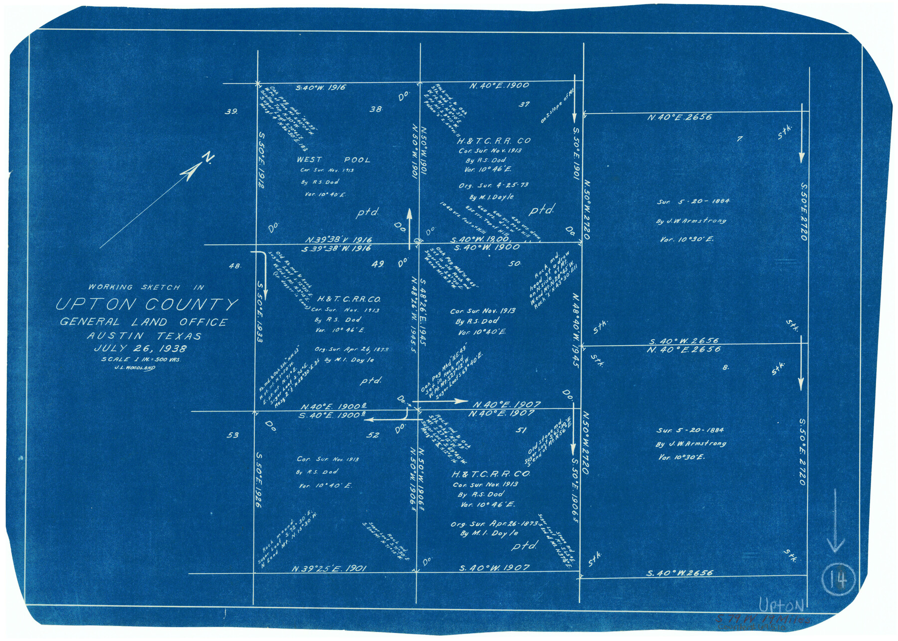
Upton County Working Sketch 14
-
Map/Doc
69510
-
Collection
General Map Collection
-
Object Dates
7/26/1938 (Creation Date)
-
People and Organizations
J.L. Woodland (Draftsman)
-
Counties
Upton
-
Subjects
Surveying Working Sketch
-
Height x Width
14.9 x 20.9 inches
37.9 x 53.1 cm
-
Scale
1" = 500 varas
Part of: General Map Collection
Foard County Sketch File 18

Print $6.00
- Digital $50.00
Foard County Sketch File 18
1888
Size 13.0 x 8.5 inches
Map/Doc 22834
Briscoe County Sketch File 15

Print $26.00
- Digital $50.00
Briscoe County Sketch File 15
Size 11.2 x 8.9 inches
Map/Doc 16522
[Sketch for Mineral Application 24072, San Jacinto River]
![65590, [Sketch for Mineral Application 24072, San Jacinto River], General Map Collection](https://historictexasmaps.com/wmedia_w700/maps/65590.tif.jpg)
Print $20.00
- Digital $50.00
[Sketch for Mineral Application 24072, San Jacinto River]
1929
Size 40.8 x 14.7 inches
Map/Doc 65590
Flight Mission No. DQN-5K, Frame 59, Calhoun County

Print $20.00
- Digital $50.00
Flight Mission No. DQN-5K, Frame 59, Calhoun County
1953
Size 18.7 x 22.3 inches
Map/Doc 84402
Hutchinson County Rolled Sketch 43

Print $40.00
- Digital $50.00
Hutchinson County Rolled Sketch 43
1992
Size 41.3 x 50.0 inches
Map/Doc 6314
Flight Mission No. DIX-10P, Frame 81, Aransas County

Print $20.00
- Digital $50.00
Flight Mission No. DIX-10P, Frame 81, Aransas County
1956
Size 18.7 x 22.4 inches
Map/Doc 83942
Llano County Working Sketch 13

Print $20.00
- Digital $50.00
Llano County Working Sketch 13
1987
Size 23.0 x 22.3 inches
Map/Doc 70631
Bowie County Sketch File 6e

Print $4.00
- Digital $50.00
Bowie County Sketch File 6e
1927
Size 11.2 x 8.4 inches
Map/Doc 14852
Hunt County Boundary File 49

Print $44.00
- Digital $50.00
Hunt County Boundary File 49
Size 9.1 x 5.2 inches
Map/Doc 55279
McMullen County Working Sketch 33

Print $20.00
- Digital $50.00
McMullen County Working Sketch 33
1959
Size 37.3 x 27.0 inches
Map/Doc 70734
Map of Washington County

Print $20.00
- Digital $50.00
Map of Washington County
1841
Size 28.5 x 29.0 inches
Map/Doc 4122

You may also like

Galveston County NRC Article 33.136 Sketch 17

Print $22.00
- Digital $50.00
Galveston County NRC Article 33.136 Sketch 17
2002
Size 24.1 x 36.4 inches
Map/Doc 78584
The Republic County of Milam. Proposed, Late Fall 1837-December 31, 1838

Print $20.00
The Republic County of Milam. Proposed, Late Fall 1837-December 31, 1838
2020
Size 17.4 x 21.6 inches
Map/Doc 96226
Maps of Gulf Intracoastal Waterway, Texas - Sabine River to the Rio Grande and connecting waterways including ship channels

Print $20.00
- Digital $50.00
Maps of Gulf Intracoastal Waterway, Texas - Sabine River to the Rio Grande and connecting waterways including ship channels
1966
Size 14.5 x 22.3 inches
Map/Doc 61978
[Galveston, Harrisburg & San Antonio from El Paso-Presidio county boundary to Presidio-Pecos county boundary]
![64717, [Galveston, Harrisburg & San Antonio from El Paso-Presidio county boundary to Presidio-Pecos county boundary], General Map Collection](https://historictexasmaps.com/wmedia_w700/maps/64717.tif.jpg)
Print $40.00
- Digital $50.00
[Galveston, Harrisburg & San Antonio from El Paso-Presidio county boundary to Presidio-Pecos county boundary]
Size 149.3 x 44.4 inches
Map/Doc 64717
[Right of Way & Track Map, The Texas & Pacific Ry. Co. Main Line]
![64672, [Right of Way & Track Map, The Texas & Pacific Ry. Co. Main Line], General Map Collection](https://historictexasmaps.com/wmedia_w700/maps/64672.tif.jpg)
Print $20.00
- Digital $50.00
[Right of Way & Track Map, The Texas & Pacific Ry. Co. Main Line]
Size 11.0 x 18.4 inches
Map/Doc 64672
Brewster County Working Sketch 98

Print $20.00
- Digital $50.00
Brewster County Working Sketch 98
1978
Size 44.9 x 28.5 inches
Map/Doc 67698
Lipscomb County Working Sketch 5

Print $20.00
- Digital $50.00
Lipscomb County Working Sketch 5
1977
Size 26.8 x 30.0 inches
Map/Doc 70581
DeWitt County Boundary File 2a

Print $2.00
- Digital $50.00
DeWitt County Boundary File 2a
Size 10.7 x 8.1 inches
Map/Doc 52513
Cameron County Rolled Sketch 24

Print $40.00
- Digital $50.00
Cameron County Rolled Sketch 24
1968
Size 30.4 x 66.7 inches
Map/Doc 8574
Presidio County Rolled Sketch T-4

Print $20.00
- Digital $50.00
Presidio County Rolled Sketch T-4
Size 46.6 x 21.7 inches
Map/Doc 10085
