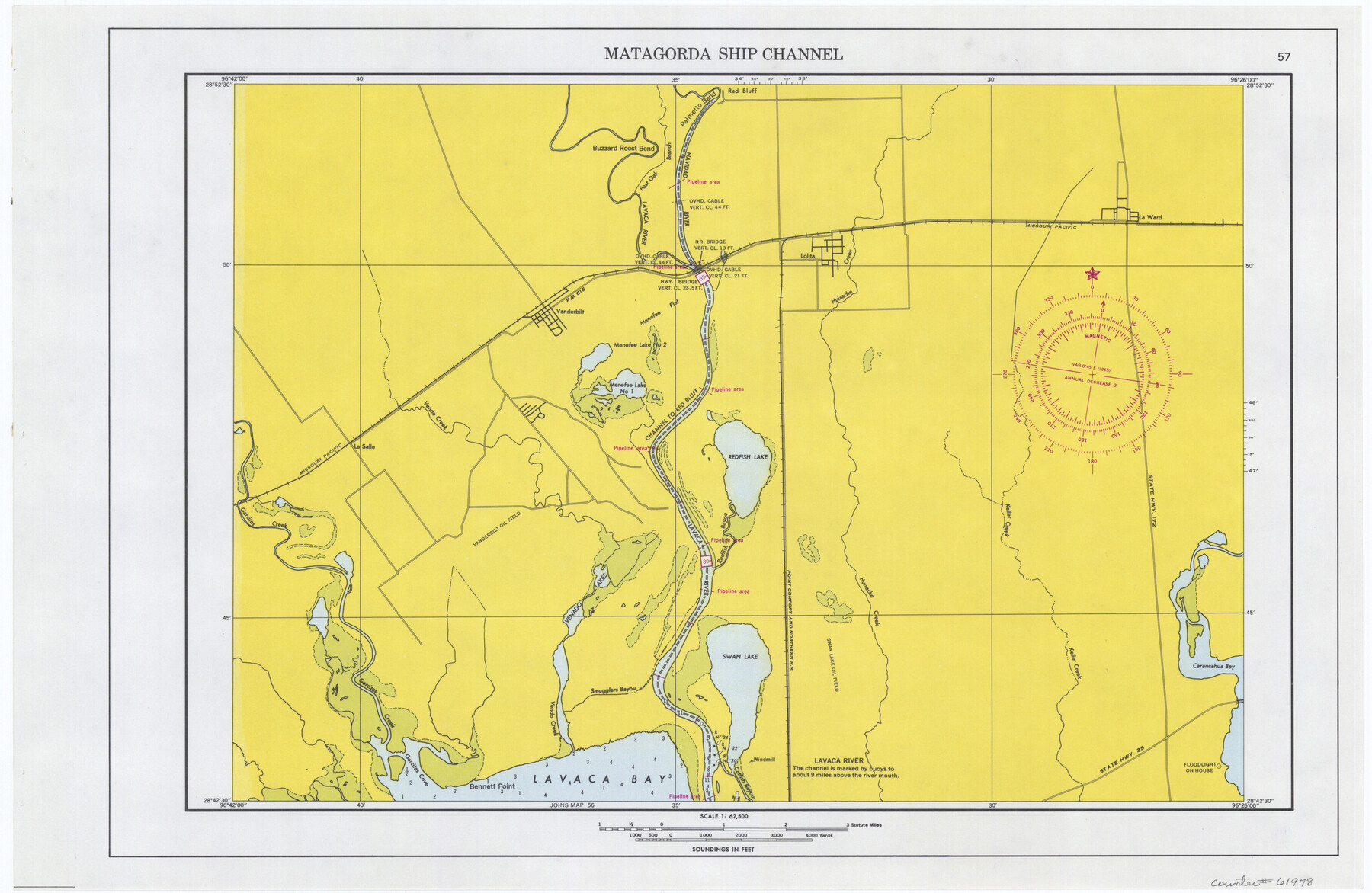
Maps of Gulf Intracoastal Waterway, Texas - Sabine River to the Rio Grande and connecting waterways including ship channels
-
Map/Doc
61978
-
Collection
General Map Collection
-
Object Dates
1966 (Creation Date)
-
Subjects
Intracoastal Waterways
-
Height x Width
14.5 x 22.3 inches
36.8 x 56.6 cm
Part of: General Map Collection
Flight Mission No. BRE-2P, Frame 48, Nueces County

Print $20.00
- Digital $50.00
Flight Mission No. BRE-2P, Frame 48, Nueces County
1956
Size 18.5 x 22.3 inches
Map/Doc 86750
Loving County Working Sketch 8

Print $40.00
- Digital $50.00
Loving County Working Sketch 8
1952
Size 21.9 x 56.6 inches
Map/Doc 70640
Current Miscellaneous File 58

Print $8.00
- Digital $50.00
Current Miscellaneous File 58
1955
Size 11.6 x 9.2 inches
Map/Doc 74052
Runnels County

Print $20.00
- Digital $50.00
Runnels County
1879
Size 22.1 x 19.2 inches
Map/Doc 3999
Carte Reduite du Globe Terrestre

Print $20.00
- Digital $50.00
Carte Reduite du Globe Terrestre
1782
Size 13.5 x 17.1 inches
Map/Doc 97117
Real County Working Sketch 83

Print $20.00
- Digital $50.00
Real County Working Sketch 83
1986
Size 25.7 x 43.0 inches
Map/Doc 71975
Marion County Working Sketch 32

Print $40.00
- Digital $50.00
Marion County Working Sketch 32
1982
Size 50.0 x 43.3 inches
Map/Doc 70808
Kent County Boundary File 6

Print $4.00
- Digital $50.00
Kent County Boundary File 6
Size 14.1 x 8.8 inches
Map/Doc 55868

Dallas County Working Sketch 15

Print $20.00
- Digital $50.00
Dallas County Working Sketch 15
1980
Size 14.3 x 11.4 inches
Map/Doc 68581
Map of Lampasas County

Print $20.00
- Digital $50.00
Map of Lampasas County
1864
Size 20.5 x 24.8 inches
Map/Doc 3793
Flight Mission No. CRK-3P, Frame 69, Refugio County

Print $20.00
- Digital $50.00
Flight Mission No. CRK-3P, Frame 69, Refugio County
1956
Size 18.5 x 22.2 inches
Map/Doc 86911
You may also like
Aransas County Working Sketch 13

Print $20.00
- Digital $50.00
Aransas County Working Sketch 13
1950
Size 26.0 x 42.2 inches
Map/Doc 67180
Darrington Plantation of the Texas Prison System, Brazoria County

Print $20.00
- Digital $50.00
Darrington Plantation of the Texas Prison System, Brazoria County
Size 16.9 x 37.4 inches
Map/Doc 62986
Tarrant County Sketch File 25

Print $4.00
- Digital $50.00
Tarrant County Sketch File 25
1873
Size 8.2 x 8.6 inches
Map/Doc 37737
Shackelford County Rolled Sketch 6

Print $20.00
- Digital $50.00
Shackelford County Rolled Sketch 6
1998
Size 24.1 x 35.9 inches
Map/Doc 7774
Pecos County Sketch File 80

Print $6.00
- Digital $50.00
Pecos County Sketch File 80
1942
Size 8.9 x 11.9 inches
Map/Doc 33918
Mills County Sketch File 26

Print $4.00
- Digital $50.00
Mills County Sketch File 26
1998
Size 14.3 x 8.8 inches
Map/Doc 31678

[Lgs. 656-695, more or less]
![90186, [Lgs. 656-695, more or less], Twichell Survey Records](https://historictexasmaps.com/wmedia_w700/maps/90186-1.tif.jpg)
Print $20.00
- Digital $50.00
[Lgs. 656-695, more or less]
Size 30.8 x 22.0 inches
Map/Doc 90186
Kerr County Working Sketch 17

Print $20.00
- Digital $50.00
Kerr County Working Sketch 17
1956
Size 20.0 x 23.7 inches
Map/Doc 70048
North and South Sulphur Rivers, Sulphur Bluff Sheet

Print $20.00
- Digital $50.00
North and South Sulphur Rivers, Sulphur Bluff Sheet
1933
Size 37.6 x 37.2 inches
Map/Doc 65163
Brewster County Boundary File 1b

Print $32.00
- Digital $50.00
Brewster County Boundary File 1b
Size 9.2 x 11.3 inches
Map/Doc 50740
Travis County State Real Property Sketch 16

Print $20.00
- Digital $50.00
Travis County State Real Property Sketch 16
2009
Size 48.1 x 36.1 inches
Map/Doc 90086