Current Miscellaneous File 58
List of Mineral Application Files, transcripts of hearings in transcript box
-
Map/Doc
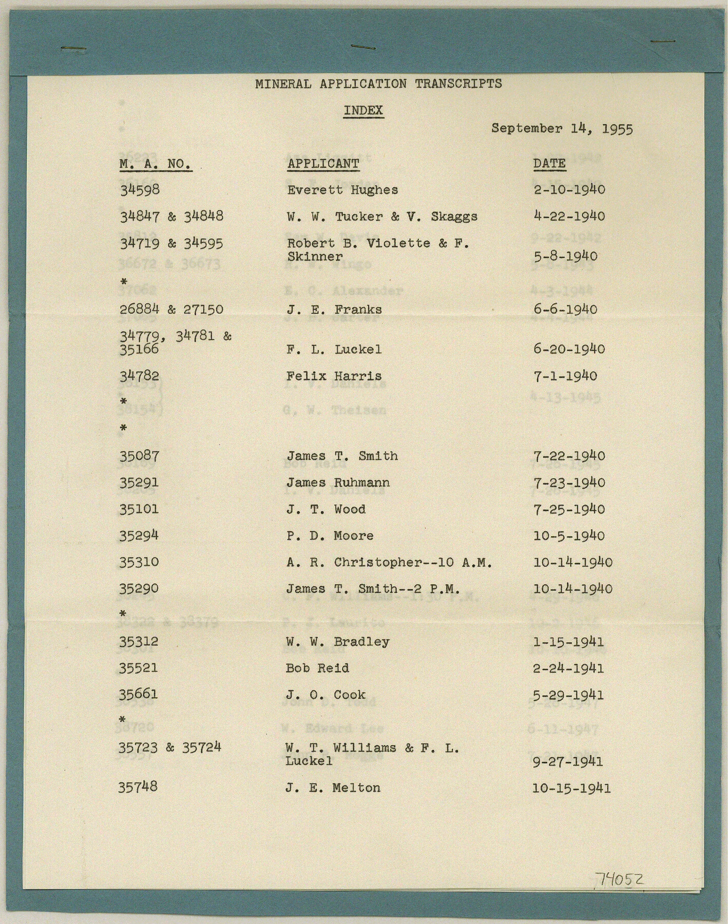
74052
-
Collection
General Map Collection
-
Object Dates
1955/9/14 (Creation Date)
1955/9/14 (File Date)
-
Subjects
Energy Surface
-
Height x Width
11.6 x 9.2 inches
29.5 x 23.4 cm
Part of: General Map Collection
Old Miscellaneous File 24

Print $6.00
- Digital $50.00
Old Miscellaneous File 24
1919
Size 14.4 x 8.7 inches
Map/Doc 75629
Flight Mission No. BQY-4M, Frame 121, Harris County

Print $20.00
- Digital $50.00
Flight Mission No. BQY-4M, Frame 121, Harris County
1953
Size 18.8 x 22.5 inches
Map/Doc 85289
Wise County Sketch File 14

Print $24.00
- Digital $50.00
Wise County Sketch File 14
1855
Size 12.8 x 8.2 inches
Map/Doc 40548
Cass County Sketch File 22

Print $8.00
- Digital $50.00
Cass County Sketch File 22
1849
Size 12.8 x 7.8 inches
Map/Doc 17427
Jim Hogg County Rolled Sketch 14

Print $20.00
- Digital $50.00
Jim Hogg County Rolled Sketch 14
2023
Size 21.1 x 30.3 inches
Map/Doc 97155
Hardin County Sketch File 12

Print $4.00
- Digital $50.00
Hardin County Sketch File 12
Size 5.4 x 8.2 inches
Map/Doc 25116
Shelby County Sketch File 25

Print $6.00
- Digital $50.00
Shelby County Sketch File 25
Size 4.8 x 5.3 inches
Map/Doc 36657
Karnes County Boundary File 5b

Print $78.00
- Digital $50.00
Karnes County Boundary File 5b
Size 7.4 x 6.1 inches
Map/Doc 55723
Childress County Sketch File 15a

Print $4.00
- Digital $50.00
Childress County Sketch File 15a
Size 8.6 x 11.7 inches
Map/Doc 18303
Wheeler County Rolled Sketch 3

Print $20.00
- Digital $50.00
Wheeler County Rolled Sketch 3
Size 31.9 x 21.9 inches
Map/Doc 8239
Anderson County Working Sketch 39

Print $20.00
- Digital $50.00
Anderson County Working Sketch 39
1986
Size 21.6 x 21.8 inches
Map/Doc 67039
Blanco County Working Sketch 31

Print $20.00
- Digital $50.00
Blanco County Working Sketch 31
1972
Size 19.1 x 25.7 inches
Map/Doc 67391
You may also like
Chambers County Sketch File 7

Print $4.00
- Digital $50.00
Chambers County Sketch File 7
1867
Size 10.2 x 8.4 inches
Map/Doc 17542
Map of Asylum & University lands situated on the waters of Hubbards Creek

Print $20.00
- Digital $50.00
Map of Asylum & University lands situated on the waters of Hubbards Creek
1857
Size 21.2 x 28.5 inches
Map/Doc 2491
Sabine Pass, Texas

Print $40.00
- Digital $50.00
Sabine Pass, Texas
1874
Size 32.2 x 53.2 inches
Map/Doc 69837
[T. & G. Ry. Main Line, Texas, Right of Way Map, Center to Gary]
![64569, [T. & G. Ry. Main Line, Texas, Right of Way Map, Center to Gary], General Map Collection](https://historictexasmaps.com/wmedia_w700/maps/64569-1.tif.jpg)
Print $40.00
- Digital $50.00
[T. & G. Ry. Main Line, Texas, Right of Way Map, Center to Gary]
1917
Size 31.5 x 76.7 inches
Map/Doc 64569
Maps of Gulf Intracoastal Waterway, Texas - Sabine River to the Rio Grande and connecting waterways including ship channels

Print $20.00
- Digital $50.00
Maps of Gulf Intracoastal Waterway, Texas - Sabine River to the Rio Grande and connecting waterways including ship channels
1966
Size 15.7 x 22.0 inches
Map/Doc 61986
Shelby County Working Sketch 2

Print $20.00
- Digital $50.00
Shelby County Working Sketch 2
Size 32.9 x 37.3 inches
Map/Doc 63855
Flight Mission No. DQN-6K, Frame 5, Calhoun County

Print $20.00
- Digital $50.00
Flight Mission No. DQN-6K, Frame 5, Calhoun County
1953
Size 18.6 x 22.1 inches
Map/Doc 84427
Encinal County

Print $20.00
- Digital $50.00
Encinal County
1886
Size 32.2 x 23.6 inches
Map/Doc 3518
Crane County Rolled Sketch 26

Print $20.00
- Digital $50.00
Crane County Rolled Sketch 26
2020
Size 36.5 x 24.5 inches
Map/Doc 96432
University Land Field Notes for Block L in El Paso County

University Land Field Notes for Block L in El Paso County
Map/Doc 81725
Armstrong County Sketch File A-13

Print $40.00
- Digital $50.00
Armstrong County Sketch File A-13
Size 12.8 x 17.7 inches
Map/Doc 13714
Dimmit County Sketch File 31

Print $20.00
- Digital $50.00
Dimmit County Sketch File 31
1894
Size 12.7 x 17.3 inches
Map/Doc 11352