Old Miscellaneous File 24
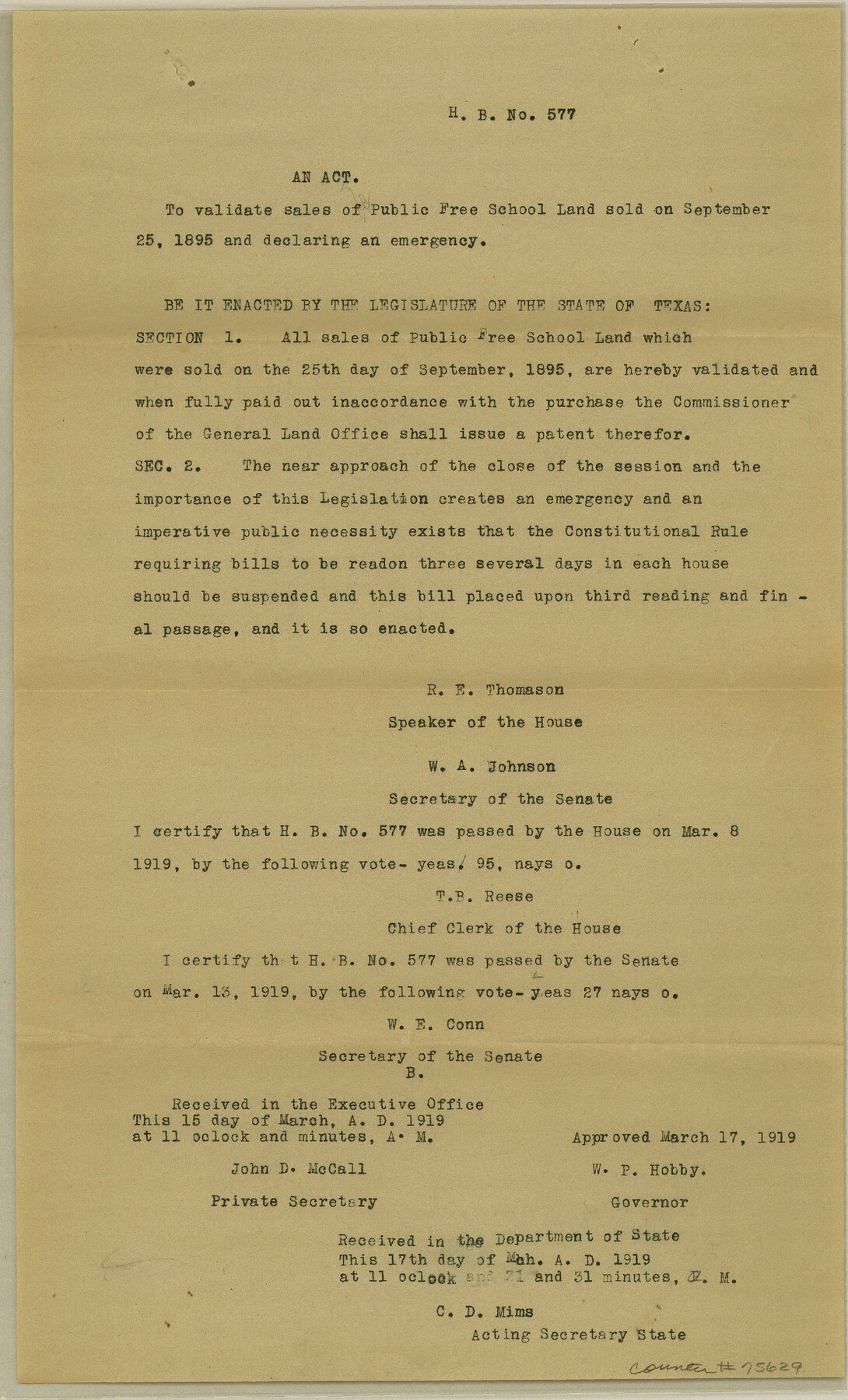
House Bill No. 577 regarding Public Free School Land sold prior to September 25th, 1895
-
Map/Doc
75629
-
Collection
General Map Collection
-
Object Dates
1919/3/20 (Creation Date)
1984/12/13 (File Date)
-
Subjects
Legal
-
Height x Width
14.4 x 8.7 inches
36.6 x 22.1 cm
Part of: General Map Collection
Pecos County Rolled Sketch 187

Print $20.00
- Digital $50.00
Pecos County Rolled Sketch 187
1985
Size 17.8 x 22.9 inches
Map/Doc 7306
Reagan County Sketch File 15

Print $4.00
- Digital $50.00
Reagan County Sketch File 15
1931
Size 8.0 x 13.3 inches
Map/Doc 35000
G.C. & S.F. Ry. Alinement and Right of Way map of Dallas Branch, Ellis County, Texas

Print $40.00
- Digital $50.00
G.C. & S.F. Ry. Alinement and Right of Way map of Dallas Branch, Ellis County, Texas
1925
Size 31.4 x 120.7 inches
Map/Doc 64547
Webb County Working Sketch 6

Print $20.00
- Digital $50.00
Webb County Working Sketch 6
1909
Size 27.8 x 28.3 inches
Map/Doc 72371
Kimble County Working Sketch 35

Print $20.00
- Digital $50.00
Kimble County Working Sketch 35
1946
Size 24.7 x 32.0 inches
Map/Doc 70103
Flight Mission No. DQN-2K, Frame 67, Calhoun County

Print $20.00
- Digital $50.00
Flight Mission No. DQN-2K, Frame 67, Calhoun County
1953
Size 18.6 x 22.3 inches
Map/Doc 84259
Fractional Township No. 8 South Range No. 2 East of the Indian Meridian, Indian Territory

Print $20.00
- Digital $50.00
Fractional Township No. 8 South Range No. 2 East of the Indian Meridian, Indian Territory
1898
Size 19.3 x 24.3 inches
Map/Doc 75204
Comal County Rolled Sketch 3

Print $20.00
- Digital $50.00
Comal County Rolled Sketch 3
1977
Size 19.0 x 17.3 inches
Map/Doc 5538
Flight Mission No. BRA-16M, Frame 85, Jefferson County

Print $20.00
- Digital $50.00
Flight Mission No. BRA-16M, Frame 85, Jefferson County
1953
Size 18.6 x 22.4 inches
Map/Doc 85697
Pecos County Rolled Sketch 161

Print $40.00
- Digital $50.00
Pecos County Rolled Sketch 161
Size 67.1 x 35.2 inches
Map/Doc 9740
Hardin County Sketch File 9

Print $4.00
- Digital $50.00
Hardin County Sketch File 9
1865
Size 12.4 x 8.2 inches
Map/Doc 25106
Chambers County Working Sketch 9

Print $20.00
- Digital $50.00
Chambers County Working Sketch 9
1946
Size 43.9 x 29.8 inches
Map/Doc 67992
You may also like

Burleson County Working Sketch 45

Print $20.00
- Digital $50.00
Burleson County Working Sketch 45
1993
Size 20.3 x 23.0 inches
Map/Doc 67764
Orange County NRC Article 33.136 Sketch 6

Print $42.00
Orange County NRC Article 33.136 Sketch 6
2025
Map/Doc 97430
Cherokee County Sketch File 12b

Print $6.00
- Digital $50.00
Cherokee County Sketch File 12b
1850
Size 7.9 x 7.7 inches
Map/Doc 18142
Controlled Mosaic by Jack Amman Photogrammetric Engineers, Inc - Sheet 35

Print $20.00
- Digital $50.00
Controlled Mosaic by Jack Amman Photogrammetric Engineers, Inc - Sheet 35
1954
Size 20.0 x 24.0 inches
Map/Doc 83488
Cottle County Sketch File 18

Print $46.00
- Digital $50.00
Cottle County Sketch File 18
2004
Size 8.0 x 11.0 inches
Map/Doc 82433
[Sketch of Pecos County School Land surveys along Pecos River in Val Verde County]
![369, [Sketch of Pecos County School Land surveys along Pecos River in Val Verde County], Maddox Collection](https://historictexasmaps.com/wmedia_w700/maps/0369-1.tif.jpg)
Print $2.00
- Digital $50.00
[Sketch of Pecos County School Land surveys along Pecos River in Val Verde County]
1882
Size 10.2 x 8.9 inches
Map/Doc 369
Henderson County Working Sketch 18

Print $20.00
- Digital $50.00
Henderson County Working Sketch 18
1941
Size 23.8 x 23.4 inches
Map/Doc 66151
Aransas County Boundary File 1

Print $14.00
- Digital $50.00
Aransas County Boundary File 1
Size 14.2 x 8.6 inches
Map/Doc 49774
Erath County Working Sketch 9

Print $20.00
- Digital $50.00
Erath County Working Sketch 9
1939
Size 18.6 x 14.8 inches
Map/Doc 69090
Briscoe County Sketch File M

Print $40.00
- Digital $50.00
Briscoe County Sketch File M
Size 36.1 x 28.0 inches
Map/Doc 11010
Working Sketch Archer County

Print $20.00
- Digital $50.00
Working Sketch Archer County
1924
Size 26.6 x 20.5 inches
Map/Doc 90257