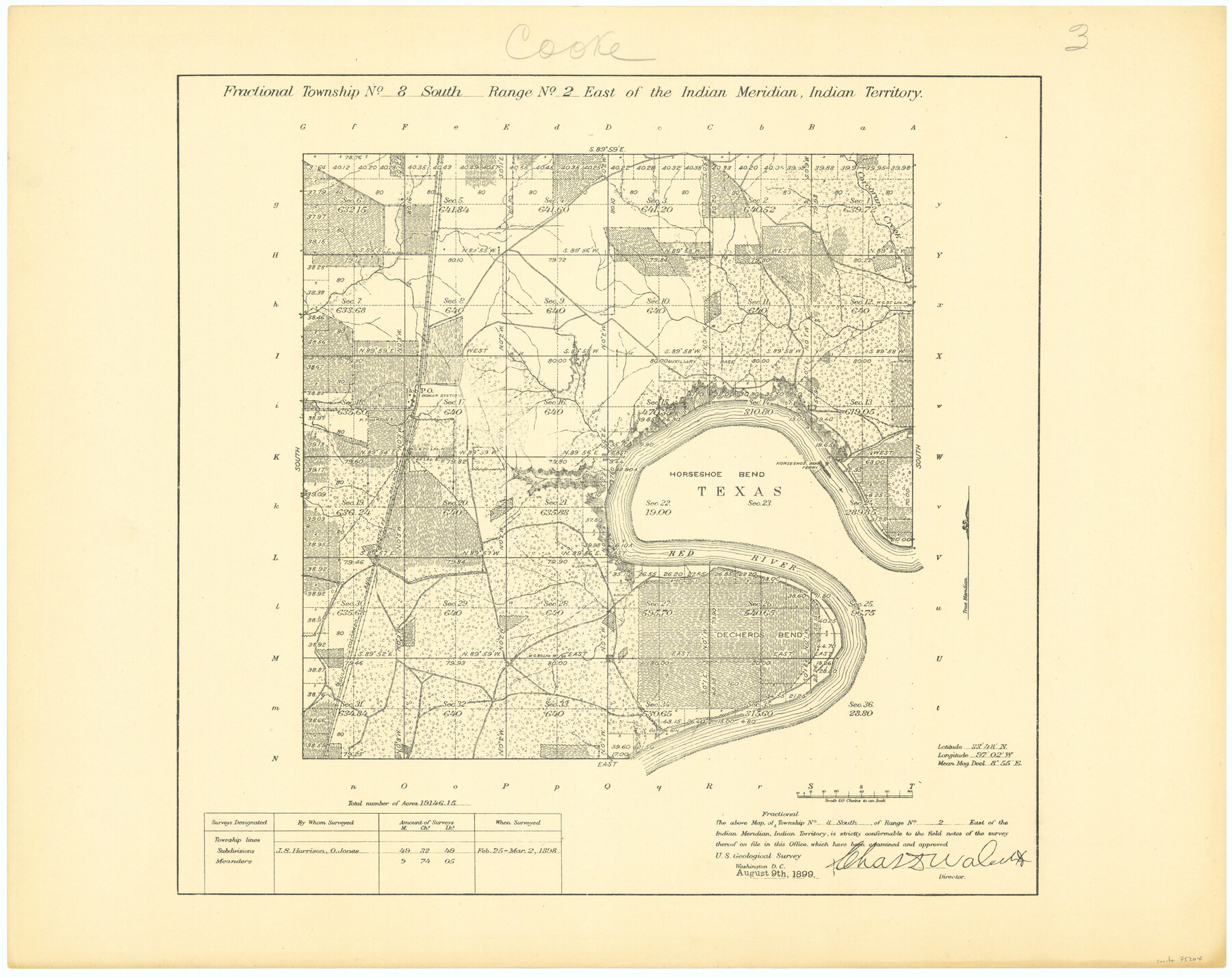
Fractional Township No. 8 South Range No. 2 East of the Indian Meridian, Indian Territory
-
Map/Doc
75204
-
Collection
General Map Collection
-
Object Dates
1898/3/2 (Creation Date)
-
Subjects
Texas Boundaries
-
Height x Width
19.3 x 24.3 inches
49.0 x 61.7 cm
Part of: General Map Collection
Current Miscellaneous File 35

Print $10.00
- Digital $50.00
Current Miscellaneous File 35
Size 14.2 x 8.7 inches
Map/Doc 73947
Flight Mission No. CGI-1N, Frame 178, Cameron County

Print $20.00
- Digital $50.00
Flight Mission No. CGI-1N, Frame 178, Cameron County
1955
Size 18.6 x 22.3 inches
Map/Doc 84513
Harris County Boundary File 39 (14)

Print $30.00
- Digital $50.00
Harris County Boundary File 39 (14)
Size 13.2 x 8.1 inches
Map/Doc 54344
Aransas County Working Sketch 23

Print $20.00
- Digital $50.00
Aransas County Working Sketch 23
1970
Size 34.6 x 40.1 inches
Map/Doc 67190
Flight Mission No. BRA-16M, Frame 64, Jefferson County

Print $20.00
- Digital $50.00
Flight Mission No. BRA-16M, Frame 64, Jefferson County
1953
Size 18.8 x 22.3 inches
Map/Doc 85681
Hemphill County Rolled Sketch 2

Print $20.00
- Digital $50.00
Hemphill County Rolled Sketch 2
Size 26.4 x 29.8 inches
Map/Doc 6185
Hartley County Sketch File 15

Print $20.00
- Digital $50.00
Hartley County Sketch File 15
Size 31.2 x 16.6 inches
Map/Doc 11737
Frio County Working Sketch Graphic Index

Print $20.00
- Digital $50.00
Frio County Working Sketch Graphic Index
1944
Size 43.0 x 41.4 inches
Map/Doc 76549
Palo Pinto County Working Sketch 1

Print $20.00
- Digital $50.00
Palo Pinto County Working Sketch 1
1903
Size 19.0 x 14.6 inches
Map/Doc 71384
Jeff Davis County Sketch File 34

Print $16.00
- Digital $50.00
Jeff Davis County Sketch File 34
1915
Size 8.5 x 5.4 inches
Map/Doc 28040
Garza County Sketch File 6

Print $8.00
- Digital $50.00
Garza County Sketch File 6
1900
Size 14.2 x 8.7 inches
Map/Doc 24056
Amistad International Reservoir on Rio Grande 102

Print $20.00
- Digital $50.00
Amistad International Reservoir on Rio Grande 102
1950
Size 28.5 x 41.2 inches
Map/Doc 75533
You may also like
Coke County Working Sketch 22

Print $20.00
- Digital $50.00
Coke County Working Sketch 22
1949
Size 21.7 x 27.7 inches
Map/Doc 68059
The Republic County of Milam. Proposed, Late Fall 1837-December 31, 1838

Print $20.00
The Republic County of Milam. Proposed, Late Fall 1837-December 31, 1838
2020
Size 17.4 x 21.6 inches
Map/Doc 96226
Flight Mission No. CGI-3N, Frame 161, Cameron County

Print $20.00
- Digital $50.00
Flight Mission No. CGI-3N, Frame 161, Cameron County
1954
Size 18.7 x 22.4 inches
Map/Doc 84625
Yoakum County

Print $20.00
- Digital $50.00
Yoakum County
1932
Size 40.2 x 29.6 inches
Map/Doc 77465
Hays County State Real Property Sketch 2

Print $20.00
- Digital $50.00
Hays County State Real Property Sketch 2
2006
Size 24.3 x 34.4 inches
Map/Doc 88619
Edwards County Sketch File 12b

Print $4.00
- Digital $50.00
Edwards County Sketch File 12b
Size 14.4 x 8.8 inches
Map/Doc 21698
Scurry County Rolled Sketch 2A

Print $20.00
- Digital $50.00
Scurry County Rolled Sketch 2A
Size 25.6 x 24.2 inches
Map/Doc 7764
Morris County Rolled Sketch 2A

Print $20.00
- Digital $50.00
Morris County Rolled Sketch 2A
Size 24.3 x 19.1 inches
Map/Doc 10250
San Jacinto River and Tributaries, Texas - Survey of 1939

Print $20.00
- Digital $50.00
San Jacinto River and Tributaries, Texas - Survey of 1939
1939
Size 27.7 x 40.5 inches
Map/Doc 60310
Terrell County Rolled Sketch 14

Print $40.00
- Digital $50.00
Terrell County Rolled Sketch 14
Size 52.6 x 16.0 inches
Map/Doc 10309
[Map of Resurvey of Block 34 and 35, Township 5 N]
![90551, [Map of Resurvey of Block 34 and 35, Township 5 N], Twichell Survey Records](https://historictexasmaps.com/wmedia_w700/maps/90551-1.tif.jpg)
Print $20.00
- Digital $50.00
[Map of Resurvey of Block 34 and 35, Township 5 N]
1915
Size 25.5 x 16.4 inches
Map/Doc 90551
Bee County Sketch File 24

Print $8.00
- Digital $50.00
Bee County Sketch File 24
1879
Size 10.2 x 8.3 inches
Map/Doc 14322