Garza County Sketch File 6
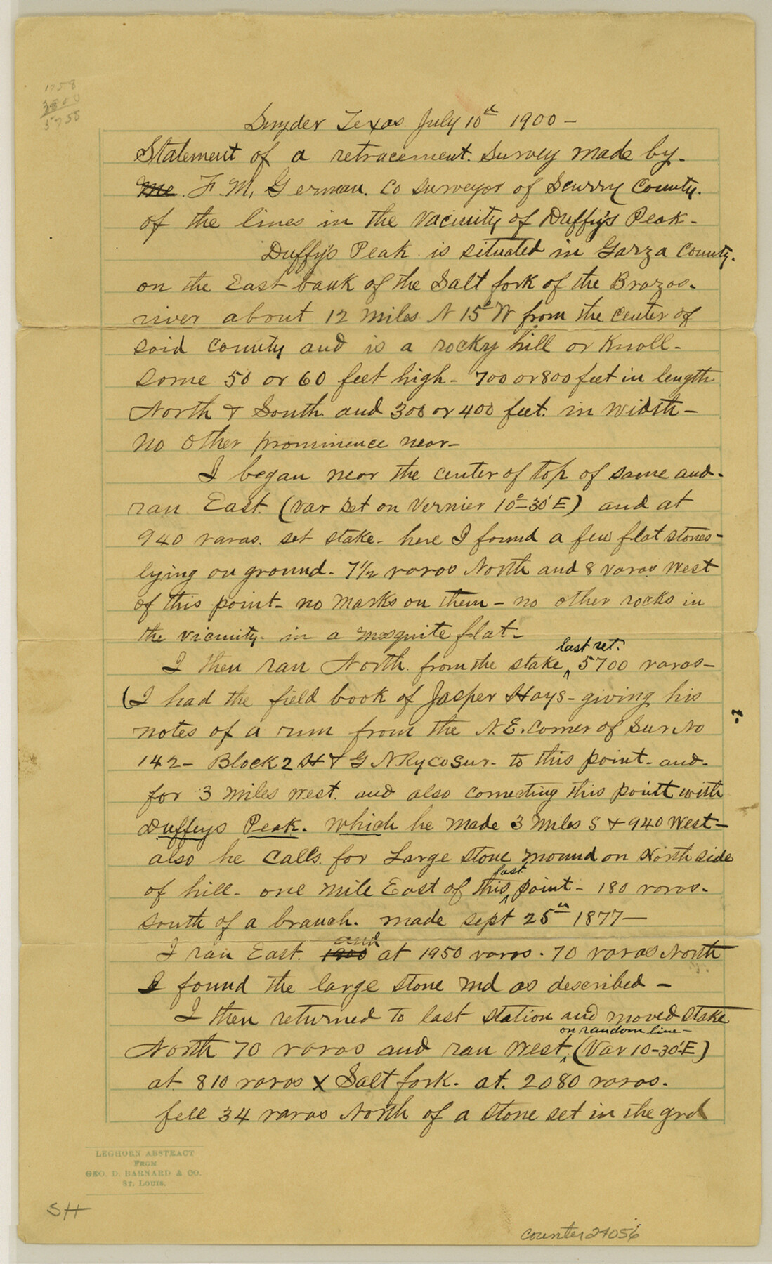
[Statement of a retracement survey of the lines in the vicinity of Duffy's Creek]
-
Map/Doc
24056
-
Collection
General Map Collection
-
Object Dates
1900/7/10 (Creation Date)
1900/7/15 (File Date)
1887 (Survey Date)
-
People and Organizations
F.M. German (Surveyor/Engineer)
Jasper Hays (Surveyor/Engineer)
W.E. Kaye (Surveyor/Engineer)
Mr. Shepherd (Surveyor/Engineer)
H.C. Knight (Surveyor/Engineer)
-
Counties
Garza Scurry
-
Subjects
Surveying Sketch File
-
Height x Width
14.2 x 8.7 inches
36.1 x 22.1 cm
-
Medium
paper, manuscript
-
Features
Duffy's Peak
Salt Fork of the Brazos River
Part of: General Map Collection
Key to Photo Index Sheets of Texas Coast Portion

Print $20.00
- Digital $50.00
Key to Photo Index Sheets of Texas Coast Portion
1954
Size 20.0 x 24.0 inches
Map/Doc 83436
Hartley County Working Sketch 2

Print $20.00
- Digital $50.00
Hartley County Working Sketch 2
1920
Size 41.8 x 30.7 inches
Map/Doc 66052
Brewster County Rolled Sketch 101

Print $40.00
- Digital $50.00
Brewster County Rolled Sketch 101
1927
Size 74.4 x 42.4 inches
Map/Doc 9196
Trinity County Boundary File 102

Print $14.00
- Digital $50.00
Trinity County Boundary File 102
Size 9.2 x 4.6 inches
Map/Doc 59480
Navigation Maps of Gulf Intracoastal Waterway, Port Arthur to Brownsville, Texas

Print $4.00
- Digital $50.00
Navigation Maps of Gulf Intracoastal Waterway, Port Arthur to Brownsville, Texas
1951
Size 16.7 x 21.4 inches
Map/Doc 65423
Haskell County Sketch File 3

Print $8.00
- Digital $50.00
Haskell County Sketch File 3
Size 9.8 x 8.8 inches
Map/Doc 26121
Medina County Working Sketch 18

Print $20.00
- Digital $50.00
Medina County Working Sketch 18
1980
Size 31.4 x 38.0 inches
Map/Doc 70933
Map of Leon County

Print $40.00
- Digital $50.00
Map of Leon County
Size 49.7 x 42.0 inches
Map/Doc 66900
Flight Mission No. DQN-1K, Frame 146, Calhoun County

Print $20.00
- Digital $50.00
Flight Mission No. DQN-1K, Frame 146, Calhoun County
1953
Size 18.7 x 22.3 inches
Map/Doc 84209
Orange County Sketch File A

Print $40.00
- Digital $50.00
Orange County Sketch File A
1890
Size 14.2 x 8.8 inches
Map/Doc 33278
Denton County Sketch File 10

Print $2.00
- Digital $50.00
Denton County Sketch File 10
1856
Size 8.5 x 13.5 inches
Map/Doc 20708
Calhoun County Rolled Sketch 30

Print $20.00
- Digital $50.00
Calhoun County Rolled Sketch 30
1974
Size 18.6 x 27.8 inches
Map/Doc 5376
You may also like
Knox County Boundary File 104

Print $10.00
- Digital $50.00
Knox County Boundary File 104
Size 9.2 x 7.4 inches
Map/Doc 65051
Knox County Rolled Sketch 18

Print $20.00
- Digital $50.00
Knox County Rolled Sketch 18
1945
Size 23.1 x 29.5 inches
Map/Doc 6558
Runnels County Sketch File 14

Print $20.00
Runnels County Sketch File 14
1884
Size 16.3 x 20.4 inches
Map/Doc 12252
Webb County Sketch File 5

Print $8.00
- Digital $50.00
Webb County Sketch File 5
1876
Size 12.8 x 8.1 inches
Map/Doc 39725
The Republic County of Bowie. January 16, 1843

Print $20.00
The Republic County of Bowie. January 16, 1843
2020
Size 19.5 x 21.7 inches
Map/Doc 96106
Plat of a portion of Buchel County, Texas

Print $20.00
- Digital $50.00
Plat of a portion of Buchel County, Texas
Size 16.0 x 26.2 inches
Map/Doc 82526
Upton County Sketch File 10

Print $18.00
- Digital $50.00
Upton County Sketch File 10
1919
Size 13.5 x 8.7 inches
Map/Doc 38839
Young County Working Sketch 8

Print $20.00
- Digital $50.00
Young County Working Sketch 8
1920
Size 17.3 x 12.6 inches
Map/Doc 62031
Flight Mission No. DIX-10P, Frame 152, Aransas County

Print $20.00
- Digital $50.00
Flight Mission No. DIX-10P, Frame 152, Aransas County
1956
Size 18.6 x 22.2 inches
Map/Doc 83954
Rhyne Simpson Addition No. 2, City of Lubbock Section 3, Block O

Print $20.00
- Digital $50.00
Rhyne Simpson Addition No. 2, City of Lubbock Section 3, Block O
1957
Size 11.7 x 18.2 inches
Map/Doc 92752
Brewster County Rolled Sketch 105

Print $20.00
- Digital $50.00
Brewster County Rolled Sketch 105
Size 27.2 x 24.5 inches
Map/Doc 5257
Jack County Sketch File 18

Print $4.00
- Digital $50.00
Jack County Sketch File 18
1880
Size 10.4 x 8.2 inches
Map/Doc 27553