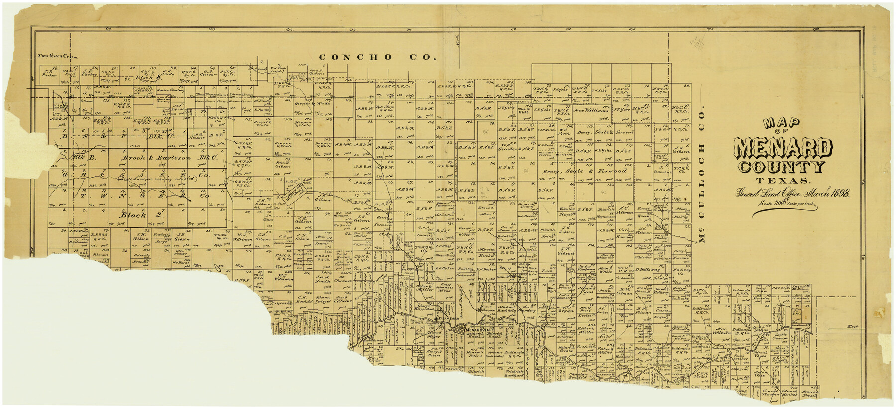
Map of Menard County
Menard County Maddox Rolled Map 15
-
Map/Doc
5042
-
Collection
Maddox Collection
-
Object Dates
1898 (Creation Date)
-
Counties
Menard
-
Height x Width
19.9 x 43.1 inches
50.6 x 109.5 cm
Part of: Maddox Collection
[Robertson Co.]
![4488, [Robertson Co.], Maddox Collection](https://historictexasmaps.com/wmedia_w700/maps/4488.tif.jpg)
Print $20.00
- Digital $50.00
[Robertson Co.]
1880
Size 32.3 x 44.3 inches
Map/Doc 4488
Map of Texas in 1836

Print $20.00
- Digital $50.00
Map of Texas in 1836
1936
Size 24.5 x 19.3 inches
Map/Doc 449
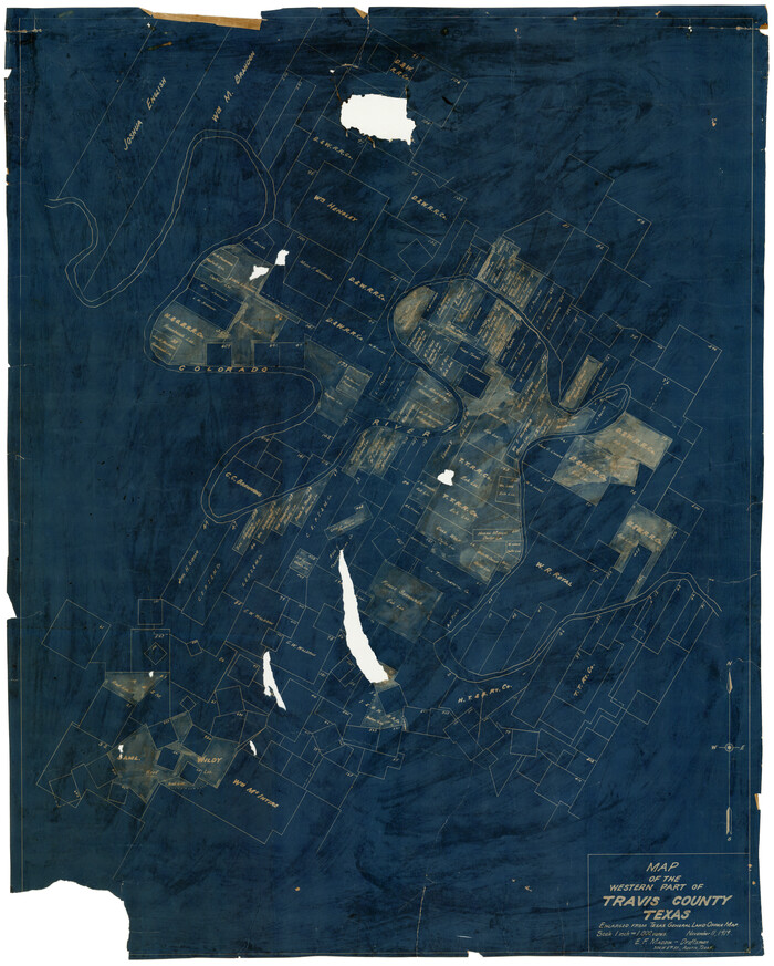
Map of the Western Part of Travis County, Texas
Print $20.00
- Digital $50.00
Map of the Western Part of Travis County, Texas
1919
Size 36.2 x 29.9 inches
Map/Doc 10754
Austin and Surrounding Properties
.tif.jpg)
Print $20.00
- Digital $50.00
Austin and Surrounding Properties
1891
Size 42.9 x 32.1 inches
Map/Doc 421
Part of Tom Green County, Texas (No. 3)

Print $20.00
- Digital $50.00
Part of Tom Green County, Texas (No. 3)
1870
Size 22.9 x 17.7 inches
Map/Doc 5047
Map of Surveys 6, 7, & 8, Block 1, D.B. Gardner 7 1/2, Block L, D.B. Gardner 7, Block T, J.P. Goen
Print $20.00
- Digital $50.00
Map of Surveys 6, 7, & 8, Block 1, D.B. Gardner 7 1/2, Block L, D.B. Gardner 7, Block T, J.P. Goen
1917
Size 11.0 x 22.6 inches
Map/Doc 10762
Bee County, Texas

Print $20.00
- Digital $50.00
Bee County, Texas
1879
Size 25.5 x 21.7 inches
Map/Doc 510

Map of surveys 191 & 192 T. C. R.R. Co. in Travis County, Texas

Print $20.00
- Digital $50.00
Map of surveys 191 & 192 T. C. R.R. Co. in Travis County, Texas
1915
Size 20.7 x 12.9 inches
Map/Doc 75555
Hansford County, Texas

Print $20.00
- Digital $50.00
Hansford County, Texas
1880
Size 19.9 x 18.9 inches
Map/Doc 528
[Sketch Showing Blocks in Hansford County, Texas]
![75818, [Sketch Showing Blocks in Hansford County, Texas], Maddox Collection](https://historictexasmaps.com/wmedia_w700/maps/75818.tif.jpg)
Print $20.00
- Digital $50.00
[Sketch Showing Blocks in Hansford County, Texas]
1890
Size 34.3 x 24.6 inches
Map/Doc 75818
Map of West Part of Galveston County, Texas

Print $20.00
- Digital $50.00
Map of West Part of Galveston County, Texas
1880
Size 28.6 x 21.9 inches
Map/Doc 716
You may also like
La Salle County Rolled Sketch 24

Print $20.00
- Digital $50.00
La Salle County Rolled Sketch 24
1955
Size 36.7 x 39.4 inches
Map/Doc 10655
Navarro County Working Sketch 17

Print $20.00
- Digital $50.00
Navarro County Working Sketch 17
2008
Size 35.3 x 36.1 inches
Map/Doc 88812
Upton County Working Sketch 25

Print $20.00
- Digital $50.00
Upton County Working Sketch 25
1953
Size 38.2 x 31.2 inches
Map/Doc 69521
Caddo Lake Subdivision, Copied from Sketch in MF 000964

Print $20.00
- Digital $50.00
Caddo Lake Subdivision, Copied from Sketch in MF 000964
1918
Size 32.5 x 28.0 inches
Map/Doc 1929
Map of Africa engraved to illustrate Mitchell's school and family geography (Inset 1: Map of Egypt / Inset 2: Map of Liberia)

Print $20.00
- Digital $50.00
Map of Africa engraved to illustrate Mitchell's school and family geography (Inset 1: Map of Egypt / Inset 2: Map of Liberia)
1839
Size 9.5 x 11.8 inches
Map/Doc 93507
Potter County Working Sketch 5

Print $20.00
- Digital $50.00
Potter County Working Sketch 5
1920
Size 41.3 x 37.1 inches
Map/Doc 71665
Collingsworth County Working Sketch 2

Print $20.00
- Digital $50.00
Collingsworth County Working Sketch 2
1957
Size 10.2 x 32.6 inches
Map/Doc 63762
Hardeman County Working Sketch Graphic Index

Print $20.00
- Digital $50.00
Hardeman County Working Sketch Graphic Index
1935
Size 42.9 x 40.5 inches
Map/Doc 76566
Maps of Gulf Intracoastal Waterway, Texas - Sabine River to the Rio Grande and connecting waterways including ship channels

Print $20.00
- Digital $50.00
Maps of Gulf Intracoastal Waterway, Texas - Sabine River to the Rio Grande and connecting waterways including ship channels
1966
Size 14.6 x 20.8 inches
Map/Doc 61995
Atascosa County Rolled Sketch 10

Print $40.00
- Digital $50.00
Atascosa County Rolled Sketch 10
1943
Size 36.0 x 77.6 inches
Map/Doc 8428
Fort Bend County Rolled Sketch 4

Print $20.00
- Digital $50.00
Fort Bend County Rolled Sketch 4
1956
Size 30.1 x 43.8 inches
Map/Doc 5894
Fisher County Sketch File 24

Print $37.00
- Digital $50.00
Fisher County Sketch File 24
1875
Size 14.3 x 8.9 inches
Map/Doc 22666