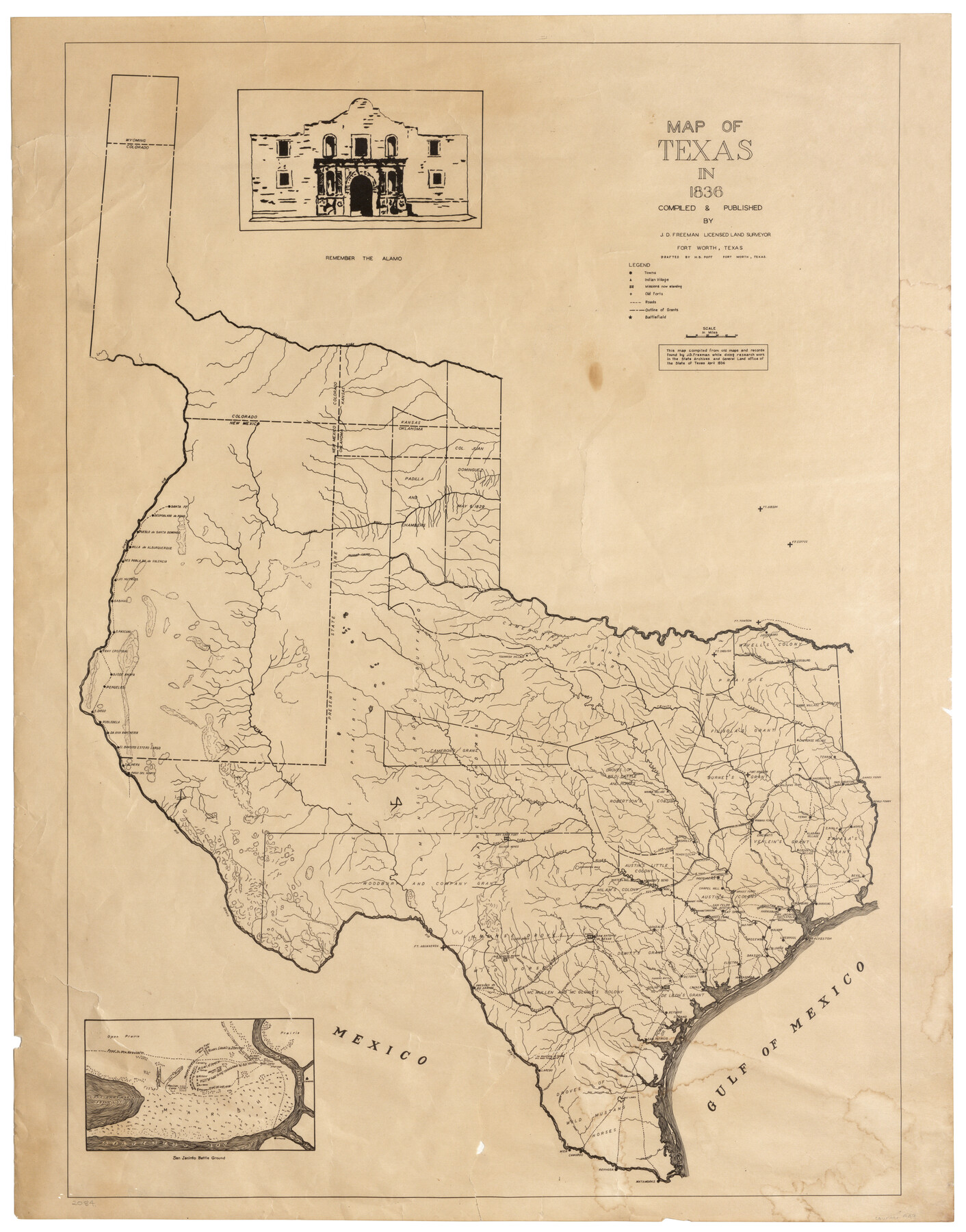
Map of Texas in 1836
-
Map/Doc
449
-
Collection
Maddox Collection
-
Object Dates
1936 (Creation Date)
-
People and Organizations
J.D. Freeman (Publisher)
J.D. Freeman (Compiler)
H.B. Poff (Draftsman)
-
Subjects
Republic of Texas
-
Height x Width
24.5 x 19.3 inches
62.2 x 49.0 cm
-
Medium
paper, etching/engraving/lithograph
-
Features
Santa Fe
Despoblado de Peno
Pueblo de Santa Domingo
Villa de Alburquerque
Des Poblado de Valencia
Las Nutrius
Sabinal
S[an] Pascual
Fray Cristobal
Ojode Anaya
Penuelos
S[an] Diego
Robledilla
Da Ana Rancheria
El Brasito Estero Largo
Salinera
Paso del Norte
Arkansas River
Rio Bravo
Pecos River
Ft. Gibson
Ft. Coffee
Ft. Towson
Canadian River
Paloduro [sic] Canyon
Red River
Touwaish Village
Ft. Inglish
Jonesboro
Millersburg
Caddo Village
Cherokee Village
Tenaha
Fort Houston
Williams Ferry
Nacogdoches
San Augustine
Gaines Ferry
Bevils Ferry
Teran
Zavala
Jasper
Alabama Village
Cincinatti
Robbins Ferry
Coshatte [sic] Village
Bevil
Tivia
Liberty
Anahuac
Lynchburg
Galveston
San Jacinto Battlefield
Houston
Harrisburg
New Washington
Liverpool
Bolivar
Columbia
Brazoria
Orozembo
Old Fort
San Felipe de Austin
Cat Springs
Groce's Ferry
Chapel Hill
Montezuma
Beasons Crossing
Electra
Matagorda
S[anta] Anna
Victoria
Lavaca
Copano
Refugio
San Patricio
Matamoras [sic]
Reynosa
Camargo
Mier
Laredo
Presidio de Rio Grande
Ft. Aguaverda
Goliad
Fannins Battle
Alamo
San Antonio de Bexar
San Saba Fort
Enchanted Rock
Waterloo
Hornsby's Bend
Mina
Independence
Washington
Tenoxtitlan
Nashville
Whaco [sic] Village
Upper Presidio Road
Lower Presidio Road
Camino Real
Woodbury and Company Grant
Padilla and Chambers
Col. Juan Dominguez
Cameron's Grant
Wavell's Colony
Filisola's Grant
Burnet's Grant
Zavala's Grant
Vehlein's Grant
Robertson's Colony
Austin's Colony
Austin's Little Colony
Milam's Colony
Dewitt's Grant
De Leon's Grant
Powers Gr.
McMullen and McGloine's Colony
Satecha or Sulphur Fork
Satecha
Sulphur Fork
Little Wishita [sic] River
Big Wishita [sic] River
Trinity [River]
Sabine River
Cross Lake
Rio Naches [sic]
R[iver] Navasota
R[iver] San Andres
Bosque River
Brazos Rio
Colorado River
Silver Mines
Rio de Medina
San Marcos Creek
San Saba River
Llano River
Rio San Gabriel
R[io] Yegua
Moore's Ferry
West Fork of San Jacinto [River]
East Rio San Jacinto
Buffalo Bayou
Drozembo
San Bernard R[iver]
Burnam's Crossing
Gonzales
Rio Guadalupe
Matagorda Bay
Rio Navidad
Coleto Creek
Rio de San Antonio
Rio Aransas
Nueces River
R[io] Sibolo [sic]
Rio Frio
Aroma River
Rio Guadalupe
Old Spanish Mission Now Deserted
Road to New Washington
Lake Annamaria Fransico
Boggy Bayou
Mexican Camp
Trail of Main Army Commanded by Gen. Houston
Galveston Bay
Road to Harrisburg
Texas Camp Sherman
Zavala's [House]
Lynch's [House]
Trail of Left Wing
San Jacinto Bay
Osa Creek
Petronita Creek
Santa Gertruda Creek
Jaboncillas Creek
Concepcion Creek
Los Olmos Creek
Palo Blanco Creek
San Antonio Creek
Salt Lakes
Calabra Creek
Olmos Creek
Salado Creek
Juanita Creek
Colorado Creek
Padre Island
Gulf of Mexico
Part of: Maddox Collection
Delta County, Texas

Print $20.00
- Digital $50.00
Delta County, Texas
1884
Size 14.1 x 20.0 inches
Map/Doc 416
Map of Tyler County, Texas

Print $20.00
- Digital $50.00
Map of Tyler County, Texas
1882
Size 28.3 x 21.4 inches
Map/Doc 669
Palo Pinto County, Texas

Print $20.00
- Digital $50.00
Palo Pinto County, Texas
1879
Size 17.8 x 19.0 inches
Map/Doc 529
Map of Bandera County, Texas

Print $20.00
- Digital $50.00
Map of Bandera County, Texas
1879
Size 19.6 x 32.6 inches
Map/Doc 691

Panola County, Texas

Print $20.00
- Digital $50.00
Panola County, Texas
1879
Size 18.0 x 19.4 inches
Map/Doc 654
Leon County, Texas

Print $20.00
- Digital $50.00
Leon County, Texas
1879
Size 25.6 x 22.3 inches
Map/Doc 563
Survey in South Austin for Mr. R.N. Graham

Print $20.00
- Digital $50.00
Survey in South Austin for Mr. R.N. Graham
Map/Doc 93795
Lubbock County, Texas

Print $20.00
- Digital $50.00
Lubbock County, Texas
1892
Size 27.8 x 22.6 inches
Map/Doc 565

Howard County, Texas

Print $20.00
- Digital $50.00
Howard County, Texas
1870
Size 22.7 x 17.9 inches
Map/Doc 733

You may also like

Foard County Working Sketch 14

Print $20.00
- Digital $50.00
Foard County Working Sketch 14
1982
Size 37.6 x 46.9 inches
Map/Doc 69205
Ector County Working Sketch 29

Print $40.00
- Digital $50.00
Ector County Working Sketch 29
1971
Size 43.9 x 63.4 inches
Map/Doc 68872

Bandera County Sketch File 22

Print $4.00
- Digital $50.00
Bandera County Sketch File 22
Size 12.6 x 7.9 inches
Map/Doc 14012
Pecos County Rolled Sketch 176

Print $20.00
- Digital $50.00
Pecos County Rolled Sketch 176
1978
Size 14.1 x 33.6 inches
Map/Doc 7296
San Augustine County, Texas

Print $20.00
- Digital $50.00
San Augustine County, Texas
1879
Size 22.7 x 17.5 inches
Map/Doc 752
Upton County Rolled Sketch 31

Print $40.00
- Digital $50.00
Upton County Rolled Sketch 31
Size 27.2 x 53.4 inches
Map/Doc 10048
J. O. Jones Land, Gaines County, Texas - Cedar Lake Meridian

Print $20.00
- Digital $50.00
J. O. Jones Land, Gaines County, Texas - Cedar Lake Meridian
Size 8.5 x 32.1 inches
Map/Doc 90792
Gray County Working Sketch 2

Print $20.00
- Digital $50.00
Gray County Working Sketch 2
1957
Size 26.7 x 27.8 inches
Map/Doc 63233
Jefferson County Rolled Sketch 34

Print $20.00
- Digital $50.00
Jefferson County Rolled Sketch 34
1957
Size 43.9 x 34.6 inches
Map/Doc 9296
