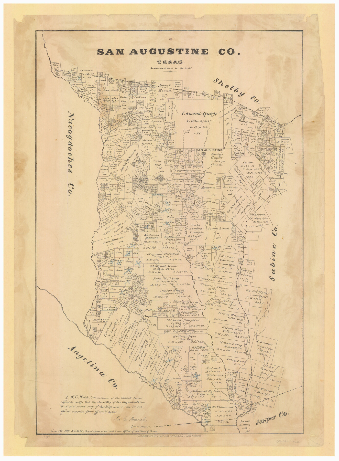
San Augustine County, Texas
-
Map/Doc
752
-
Collection
Maddox Collection
-
Object Dates
1879 (Creation Date)
1879 (Copyright Date)
-
People and Organizations
General Land Office (Publisher)
W.C. Walsh (GLO Commissioner)
August Gast & Co. (Lithographer)
-
Counties
San Augustine Shelby Jasper
-
Subjects
County
-
Height x Width
22.7 x 17.5 inches
57.7 x 44.5 cm
-
Medium
paper, etching/engraving/lithograph
-
Scale
1:4000
-
Comments
Conservation funded in 2011.
-
Features
Chiamon B[ayou]
Clear Creek
Baer [sic] Creek
Angelina R[iver]
Attoyac R[iver]
Harvey B[ayou]
Sandy Creek
Comeselano Creek
Cany Creek
Arenoso Creek
Turkey Creek
Dogwood B[ayou]
Ayish Bayou
Coney Creek
Speer Creek
San Augustine
Palo Gaucho B[ayou]
Venudo Creek
Part of: Maddox Collection
Motley County, Texas

Print $20.00
- Digital $50.00
Motley County, Texas
1883
Size 23.6 x 20.7 inches
Map/Doc 743
[Joaquin Galan Grant, Webb County]
![583, [Joaquin Galan Grant, Webb County], Maddox Collection](https://historictexasmaps.com/wmedia_w700/maps/583-1.tif.jpg)
Print $20.00
- Digital $50.00
[Joaquin Galan Grant, Webb County]
1882
Size 12.4 x 11.7 inches
Map/Doc 583
Map of Comal County, Texas

Print $20.00
- Digital $50.00
Map of Comal County, Texas
1879
Size 23.4 x 28.6 inches
Map/Doc 701
[Sketch Showing Surveys in Schleicher, Menard & Concho Counties, Texas]
![75782, [Sketch Showing Surveys in Schleicher, Menard & Concho Counties, Texas], Maddox Collection](https://historictexasmaps.com/wmedia_w700/maps/75782.tif.jpg)
Print $20.00
- Digital $50.00
[Sketch Showing Surveys in Schleicher, Menard & Concho Counties, Texas]
Size 16.1 x 28.9 inches
Map/Doc 75782
Resurvey of H.L. Upshur's April 23, 1853 meanders of the Colorado River from the NE corner of Isaac Decker league to the Congress Avenue Bridge

Print $20.00
- Digital $50.00
Resurvey of H.L. Upshur's April 23, 1853 meanders of the Colorado River from the NE corner of Isaac Decker league to the Congress Avenue Bridge
1915
Size 24.0 x 16.3 inches
Map/Doc 75773
[Littlefield & White Survey, Kimble County, Texas]
![570, [Littlefield & White Survey, Kimble County, Texas], Maddox Collection](https://historictexasmaps.com/wmedia_w700/maps/0570.tif.jpg)
Print $20.00
- Digital $50.00
[Littlefield & White Survey, Kimble County, Texas]
Size 18.6 x 14.2 inches
Map/Doc 570
Frio County, Texas

Print $20.00
- Digital $50.00
Frio County, Texas
1870
Size 20.9 x 21.3 inches
Map/Doc 729
[Marion County, Texas]
![75777, [Marion County, Texas], Maddox Collection](https://historictexasmaps.com/wmedia_w700/maps/75777.tif.jpg)
Print $20.00
- Digital $50.00
[Marion County, Texas]
1901
Size 26.5 x 24.1 inches
Map/Doc 75777
[Sketch showing voting precincts in Jim Hogg and Brooks Counties]
![4497, [Sketch showing voting precincts in Jim Hogg and Brooks Counties], Maddox Collection](https://historictexasmaps.com/wmedia_w700/maps/4497-1.tif.jpg)
Print $20.00
- Digital $50.00
[Sketch showing voting precincts in Jim Hogg and Brooks Counties]
Size 10.1 x 18.2 inches
Map/Doc 4497
[Surveying Sketch of Francisco Guerra, Antonio Ramirez, Diego Ynojosa, et al on Rio Grande, Starr County]
![5073, [Surveying Sketch of Francisco Guerra, Antonio Ramirez, Diego Ynojosa, et al on Rio Grande, Starr County], Maddox Collection](https://historictexasmaps.com/wmedia_w700/maps/5073-1.tif.jpg)
Print $20.00
- Digital $50.00
[Surveying Sketch of Francisco Guerra, Antonio Ramirez, Diego Ynojosa, et al on Rio Grande, Starr County]
1914
Size 21.7 x 13.0 inches
Map/Doc 5073
Loving County, Texas

Print $20.00
- Digital $50.00
Loving County, Texas
1889
Size 18.8 x 23.8 inches
Map/Doc 638
Map of Walker County, Texas

Print $20.00
- Digital $50.00
Map of Walker County, Texas
1879
Size 19.9 x 16.6 inches
Map/Doc 655
You may also like
Map of Mason County

Print $20.00
- Digital $50.00
Map of Mason County
1859
Size 28.4 x 22.4 inches
Map/Doc 3838
Martin County Sketch File 13

Print $4.00
- Digital $50.00
Martin County Sketch File 13
1941
Size 14.2 x 9.1 inches
Map/Doc 30669
Crosby County Sketch File 23

Print $20.00
- Digital $50.00
Crosby County Sketch File 23
1913
Size 15.0 x 27.2 inches
Map/Doc 11254
Flight Mission No. DQN-2K, Frame 81, Calhoun County

Print $20.00
- Digital $50.00
Flight Mission No. DQN-2K, Frame 81, Calhoun County
1953
Size 18.7 x 22.3 inches
Map/Doc 84273

Cooke County Working Sketch 3

Print $20.00
- Digital $50.00
Cooke County Working Sketch 3
1926
Size 27.5 x 39.9 inches
Map/Doc 68240
Matagorda Light to Aransas Pass

Print $20.00
- Digital $50.00
Matagorda Light to Aransas Pass
1966
Size 36.0 x 45.0 inches
Map/Doc 73399
Houston County

Print $20.00
- Digital $50.00
Houston County
1868
Size 24.3 x 25.0 inches
Map/Doc 4568
Burnet County Working Sketch 24

Print $20.00
- Digital $50.00
Burnet County Working Sketch 24
1990
Size 19.9 x 26.8 inches
Map/Doc 67867
Aransas County Sketch File B

Print $4.00
- Digital $50.00
Aransas County Sketch File B
Size 6.9 x 11.4 inches
Map/Doc 13216
Gonzales County Working Sketch 4a

Print $20.00
- Digital $50.00
Gonzales County Working Sketch 4a
1979
Size 30.9 x 32.2 inches
Map/Doc 63219
Gulf Intracoastal Waterway - Aransas Bay to Corpus Christi Bay - Modified Route Main Channel

Print $20.00
- Digital $50.00
Gulf Intracoastal Waterway - Aransas Bay to Corpus Christi Bay - Modified Route Main Channel
Size 30.9 x 41.9 inches
Map/Doc 61904