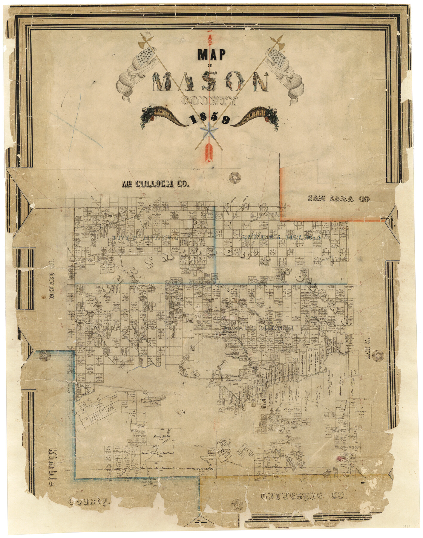
Map of Mason County
-
Map/Doc
3838
-
Collection
General Map Collection
-
Object Dates
1859 (Creation Date)
-
People and Organizations
Texas General Land Office (Publisher)
F.H. Arlitt (Draftsman)
-
Counties
Mason
-
Subjects
County
-
Height x Width
28.4 x 22.4 inches
72.1 x 56.9 cm
-
Comments
Conservation funded in 2004 with donation from Carson and Bush Professional Surveyors, Inc.
-
Features
Bear Creek
Mountain Spring
Fort Chadbourne Road
Salt Fork of Llano River
Middle Fork of Llano River
East Fork of Llano River
Llano River
Comanche Creek
Mason (abandoned)
Mill Creek
Cow Creek
Salinas Creek
James River
Schep Creek
Threadgills Creek
Salt Creek
West Fork of James River
East Fork of James River
Buffalo Creek
Peters Creek
Edwards Creek
Mesquite Creek
Medlins Creek
San Saba River
Postoak [sic] Creek
Road from Fort McCavett to Fort Mason
Fort McCavett Road
Fort Mason Road
Katemsys Creek
Tiger Creek
Grape Creek
Woolf Creek
Hackberry Creek
Camp Creek
Cherokee Creek
Trout Creek
South Branch of Trout Creek
Elm Creek
Henandez Creek
Willow Creek
Mason
Fort Mason
Honey Creek
Part of: General Map Collection
Flight Mission No. DCL-6C, Frame 54, Kenedy County

Print $20.00
- Digital $50.00
Flight Mission No. DCL-6C, Frame 54, Kenedy County
1943
Size 18.6 x 22.4 inches
Map/Doc 85896
Tarrant County Working Sketch Graphic Index

Print $20.00
- Digital $50.00
Tarrant County Working Sketch Graphic Index
1942
Size 44.0 x 35.8 inches
Map/Doc 76708
Culberson County Sketch File 3

Print $58.00
- Digital $50.00
Culberson County Sketch File 3
Size 8.0 x 3.3 inches
Map/Doc 20112
[Right of Way & Track Map, The Texas & Pacific Ry. Co. Main Line]
![64689, [Right of Way & Track Map, The Texas & Pacific Ry. Co. Main Line], General Map Collection](https://historictexasmaps.com/wmedia_w700/maps/64689.tif.jpg)
Print $20.00
- Digital $50.00
[Right of Way & Track Map, The Texas & Pacific Ry. Co. Main Line]
Size 11.0 x 19.0 inches
Map/Doc 64689
Val Verde County Working Sketch 9

Print $20.00
- Digital $50.00
Val Verde County Working Sketch 9
1917
Size 19.4 x 30.9 inches
Map/Doc 72144
Schleicher County Working Sketch 26

Print $20.00
- Digital $50.00
Schleicher County Working Sketch 26
1962
Size 27.3 x 30.0 inches
Map/Doc 63828
Terry County Boundary File 5

Print $2.00
- Digital $50.00
Terry County Boundary File 5
Size 14.2 x 8.9 inches
Map/Doc 59257
Harris County Rolled Sketch 42

Print $20.00
- Digital $50.00
Harris County Rolled Sketch 42
1919
Size 15.7 x 19.5 inches
Map/Doc 6100
Val Verde County Sketch File AAA3

Print $20.00
- Digital $50.00
Val Verde County Sketch File AAA3
Size 19.1 x 19.2 inches
Map/Doc 12541
Nueces County Sketch File 23

Print $36.00
- Digital $50.00
Nueces County Sketch File 23
1886
Size 11.2 x 8.6 inches
Map/Doc 32563
Hutchinson County Rolled Sketch 40

Print $20.00
- Digital $50.00
Hutchinson County Rolled Sketch 40
1981
Size 26.8 x 37.6 inches
Map/Doc 6301
Flight Mission No. DAG-23K, Frame 172, Matagorda County

Print $20.00
- Digital $50.00
Flight Mission No. DAG-23K, Frame 172, Matagorda County
1953
Size 18.6 x 16.0 inches
Map/Doc 86510
You may also like
A New Map of Texas with the Contiguous American & Mexican States

Print $20.00
- Digital $50.00
A New Map of Texas with the Contiguous American & Mexican States
1839
Size 13.5 x 16.1 inches
Map/Doc 93941
Duval County Rolled Sketch 32

Print $20.00
- Digital $50.00
Duval County Rolled Sketch 32
Size 38.5 x 37.3 inches
Map/Doc 8817
Amistad International Reservoir on Rio Grande 76

Print $20.00
- Digital $50.00
Amistad International Reservoir on Rio Grande 76
1949
Size 28.5 x 40.2 inches
Map/Doc 75504
Flight Mission No. BRA-16M, Frame 182, Jefferson County

Print $20.00
- Digital $50.00
Flight Mission No. BRA-16M, Frame 182, Jefferson County
1953
Size 18.6 x 22.4 inches
Map/Doc 85780
Flight Mission No. DAG-24K, Frame 38, Matagorda County

Print $20.00
- Digital $50.00
Flight Mission No. DAG-24K, Frame 38, Matagorda County
1953
Size 18.5 x 15.8 inches
Map/Doc 86525
Taylor County Sketch File 20

Print $20.00
- Digital $50.00
Taylor County Sketch File 20
1950
Size 32.1 x 46.1 inches
Map/Doc 10385
Brazos River Conservation and Reclamation District Official Boundary Line Survey

Print $20.00
- Digital $50.00
Brazos River Conservation and Reclamation District Official Boundary Line Survey
Size 36.6 x 24.6 inches
Map/Doc 90128
Harris County Working Sketch 119

Print $20.00
- Digital $50.00
Harris County Working Sketch 119
1984
Size 30.8 x 42.2 inches
Map/Doc 66011
McMullen County Sketch File 16

Print $24.00
- Digital $50.00
McMullen County Sketch File 16
1876
Size 5.3 x 8.3 inches
Map/Doc 31365

Baylor County Sketch File 12B

Print $6.00
- Digital $50.00
Baylor County Sketch File 12B
1900
Size 13.4 x 9.0 inches
Map/Doc 14152
