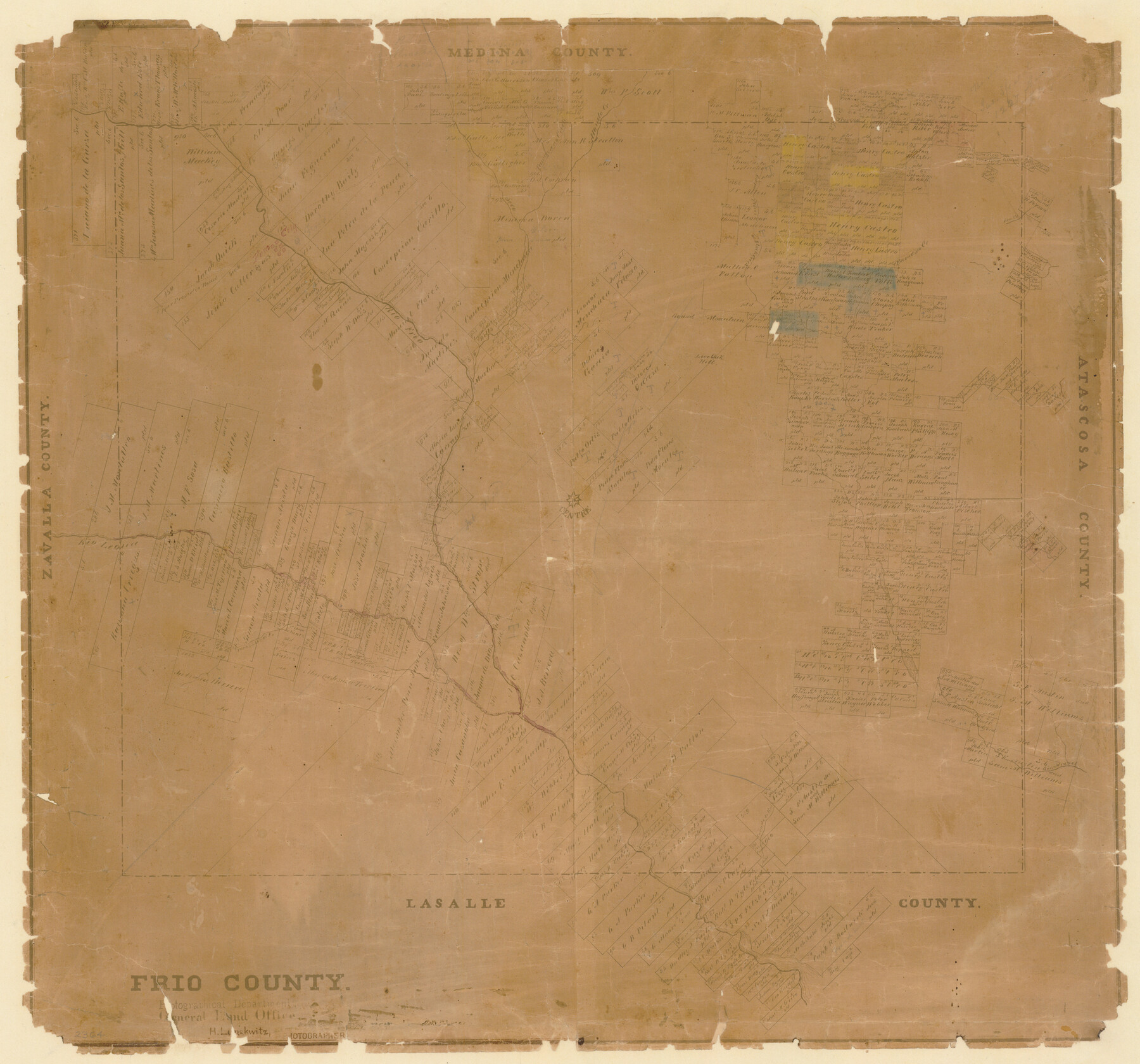
Frio County, Texas
-
Map/Doc
729
-
Collection
Maddox Collection
-
Object Dates
1870 (Creation Date)
-
People and Organizations
General Land Office (Publisher)
General Land Office Photographical Department (Printer)
-
Counties
Frio
-
Subjects
County
-
Height x Width
20.9 x 21.3 inches
53.1 x 54.1 cm
-
Medium
photograph
-
Comments
Conservation funded in 2012 by Friends of the Texas General Land Office.
-
Features
Frio City
Canada de Ruiz [Creek]
San Manuel [Creek]
Todos Santos Creek
Rio Leona
Round Mountain
Elm Creek
Escondido Creek
Rio Frio
Hondo Creek
Upper Presidio Road
Secco Creek
Black Creek
Gasper Flores Creek
Gasper Flores or Black Creek
Naran Creek
Bear Creek
Tawacano Creek
Part of: Maddox Collection
Dickens County, Texas

Print $20.00
- Digital $50.00
Dickens County, Texas
1891
Size 24.5 x 20.4 inches
Map/Doc 707
[Joaquin Galan Grant, Webb County]
![583, [Joaquin Galan Grant, Webb County], Maddox Collection](https://historictexasmaps.com/wmedia_w700/maps/583-1.tif.jpg)
Print $20.00
- Digital $50.00
[Joaquin Galan Grant, Webb County]
1882
Size 12.4 x 11.7 inches
Map/Doc 583
Deaf Smith County, Texas

Print $20.00
- Digital $50.00
Deaf Smith County, Texas
1880
Size 22.9 x 25.6 inches
Map/Doc 678
Rough sketch showing survey made for L.T. Eck Block 14 and part of Block 13, Fairview Park, South Austin, Texas

Print $2.00
- Digital $50.00
Rough sketch showing survey made for L.T. Eck Block 14 and part of Block 13, Fairview Park, South Austin, Texas
1914
Size 9.0 x 14.4 inches
Map/Doc 467
[Sketch of surveys in Knox County]
![555, [Sketch of surveys in Knox County], Maddox Collection](https://historictexasmaps.com/wmedia_w700/maps/555.tif.jpg)
Print $20.00
- Digital $50.00
[Sketch of surveys in Knox County]
Size 27.1 x 31.1 inches
Map/Doc 555
Map of the O-X Ranch in Cottle County, Texas
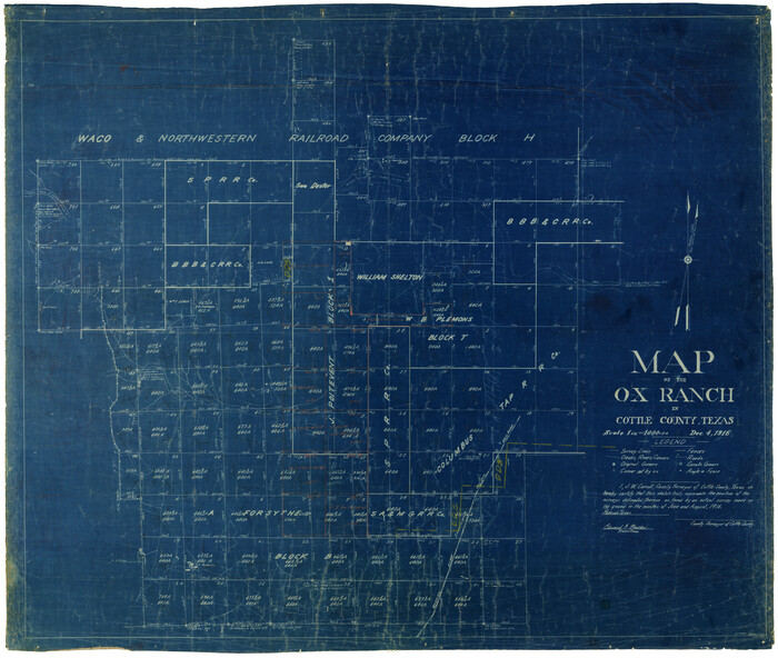
Print $20.00
- Digital $50.00
Map of the O-X Ranch in Cottle County, Texas
1916
Size 30.4 x 35.0 inches
Map/Doc 4438
Map of Bexar County, Texas

Print $20.00
- Digital $50.00
Map of Bexar County, Texas
1879
Size 25.1 x 29.7 inches
Map/Doc 530
Map of Brazos County, Texas

Print $20.00
- Digital $50.00
Map of Brazos County, Texas
1879
Size 21.6 x 15.3 inches
Map/Doc 597
[Marion County, Texas]
![75777, [Marion County, Texas], Maddox Collection](https://historictexasmaps.com/wmedia_w700/maps/75777.tif.jpg)
Print $20.00
- Digital $50.00
[Marion County, Texas]
1901
Size 26.5 x 24.1 inches
Map/Doc 75777
Red River County, Texas

Print $20.00
- Digital $50.00
Red River County, Texas
1870
Size 23.2 x 18.7 inches
Map/Doc 748
[Sketch of Blocks in Swisher, Deaf Smith, Randall and Castro Counties, Texas]
![75559, [Sketch of Blocks in Swisher, Deaf Smith, Randall and Castro Counties, Texas], Maddox Collection](https://historictexasmaps.com/wmedia_w700/maps/75559.tif.jpg)
Print $20.00
- Digital $50.00
[Sketch of Blocks in Swisher, Deaf Smith, Randall and Castro Counties, Texas]
1882
Size 22.0 x 22.8 inches
Map/Doc 75559
Resurvey of H.L. Upshur's April 23, 1853 meanders of the Colorado River from the NE corner of Isaac Decker league to the Congress Avenue Bridge

Print $20.00
- Digital $50.00
Resurvey of H.L. Upshur's April 23, 1853 meanders of the Colorado River from the NE corner of Isaac Decker league to the Congress Avenue Bridge
1915
Size 24.1 x 15.8 inches
Map/Doc 75774
You may also like
Sketch Showing Property Lines of Harlem State Farm

Print $20.00
- Digital $50.00
Sketch Showing Property Lines of Harlem State Farm
Size 16.0 x 30.2 inches
Map/Doc 62982
United States - Gulf Coast - Galveston to Rio Grande

Print $20.00
- Digital $50.00
United States - Gulf Coast - Galveston to Rio Grande
1919
Size 27.1 x 18.3 inches
Map/Doc 72745
Map of the State of Texas

Print $40.00
- Digital $50.00
Map of the State of Texas
1879
Size 102.3 x 106.1 inches
Map/Doc 16974
Current Miscellaneous File 80

Print $8.00
- Digital $50.00
Current Miscellaneous File 80
Size 13.7 x 8.7 inches
Map/Doc 74213
[Map of Denton County]
![4529, [Map of Denton County], General Map Collection](https://historictexasmaps.com/wmedia_w700/maps/4529-1.tif.jpg)
Print $20.00
- Digital $50.00
[Map of Denton County]
1853
Size 24.5 x 29.1 inches
Map/Doc 4529
Tom Green County Rolled Sketch 12

Print $40.00
- Digital $50.00
Tom Green County Rolled Sketch 12
1951
Size 51.0 x 42.5 inches
Map/Doc 10000
Cottle County

Print $20.00
- Digital $50.00
Cottle County
1908
Size 45.0 x 41.0 inches
Map/Doc 66789
Gulf Oil Corp. Fishgide - Matagorda

Gulf Oil Corp. Fishgide - Matagorda
1960
Size 12.4 x 22.4 inches
Map/Doc 75976
Palo Pinto County Sketch File 3

Print $20.00
- Digital $50.00
Palo Pinto County Sketch File 3
1850
Size 24.6 x 19.3 inches
Map/Doc 12132
Lee County Working Sketch 19

Print $20.00
- Digital $50.00
Lee County Working Sketch 19
1991
Size 33.1 x 20.1 inches
Map/Doc 70398
[Portion of Harris County]
![78481, [Portion of Harris County], General Map Collection](https://historictexasmaps.com/wmedia_w700/maps/78481.tif.jpg)
Print $2.00
- Digital $50.00
[Portion of Harris County]
Size 7.9 x 5.1 inches
Map/Doc 78481
University of Texas System University Lands

Print $20.00
- Digital $50.00
University of Texas System University Lands
Size 17.8 x 23.4 inches
Map/Doc 93245