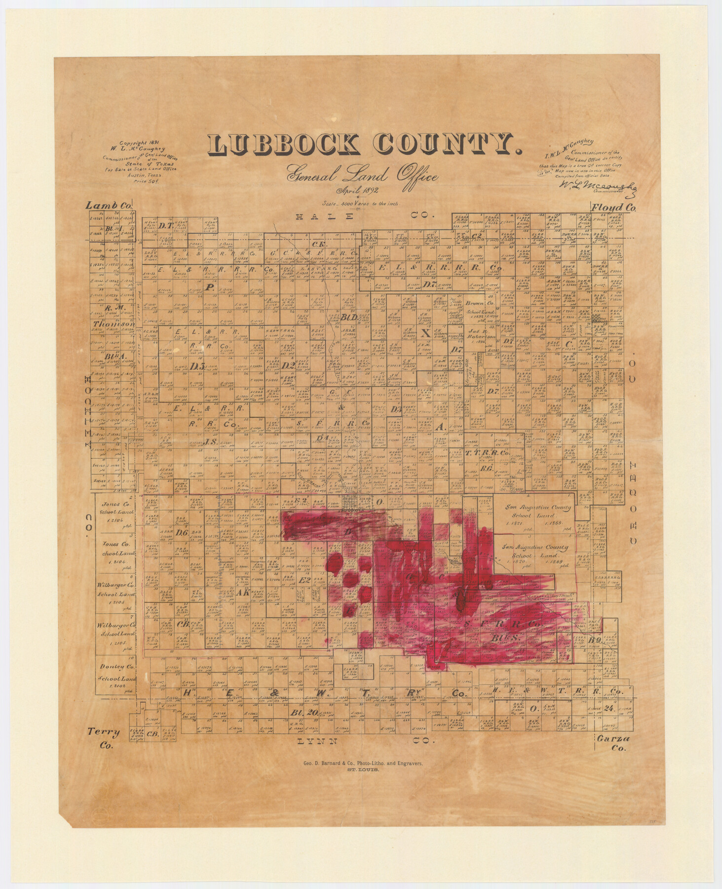
Lubbock County, Texas
-
Map/Doc
565
-
Collection
Maddox Collection
-
Object Dates
1892 (Creation Date)
1891 (Copyright Date)
-
People and Organizations
General Land Office (Publisher)
Geo. D. Barnard and Company, Photo Litho. (Printer)
W.L. McGaughey (GLO Commissioner)
-
Counties
Lubbock
-
Subjects
County
-
Height x Width
27.8 x 22.6 inches
70.6 x 57.4 cm
-
Medium
paper, etching/engraving/lithograph
-
Scale
1:4000
-
Comments
Conservation funded in 2009.
-
Features
Escacado
North Fork of Double Mountain Fork of Brazos River
Casa Marea [sic] or Yellow House Creek
Casa Marea Creek
Yellow House Creek
Lubbock
Brazos River
Part of: Maddox Collection
Part of Tom Green County, Texas (No. 1)

Print $20.00
- Digital $50.00
Part of Tom Green County, Texas (No. 1)
1870
Size 22.8 x 17.7 inches
Map/Doc 759
Throckmorton County, Texas

Print $20.00
- Digital $50.00
Throckmorton County, Texas
1880
Size 28.8 x 22.5 inches
Map/Doc 627
Map of Concho County, Texas

Print $20.00
- Digital $50.00
Map of Concho County, Texas
1879
Size 28.8 x 23.9 inches
Map/Doc 703
[Pitchfork Ranch]
![4480, [Pitchfork Ranch], Maddox Collection](https://historictexasmaps.com/wmedia_w700/maps/4480.tif.jpg)
Print $20.00
- Digital $50.00
[Pitchfork Ranch]
1915
Size 20.8 x 17.2 inches
Map/Doc 4480
King County Survey made by A.C. Tackitt and W.D. Twichell

Print $20.00
- Digital $50.00
King County Survey made by A.C. Tackitt and W.D. Twichell
1916
Size 27.5 x 25.1 inches
Map/Doc 5069
Austin County, Texas

Print $20.00
- Digital $50.00
Austin County, Texas
1879
Size 23.5 x 28.8 inches
Map/Doc 689
Revised Sectional Map No. 3 showing land surveys in counties of Loving, Reeves and Culberson and portions of Winkler, Ward, Pecos and Jeff Davis, Texas

Print $20.00
- Digital $50.00
Revised Sectional Map No. 3 showing land surveys in counties of Loving, Reeves and Culberson and portions of Winkler, Ward, Pecos and Jeff Davis, Texas
Size 19.0 x 24.7 inches
Map/Doc 4478
Haskell County

Print $20.00
- Digital $50.00
Haskell County
1888
Size 41.4 x 33.9 inches
Map/Doc 399
Map of Chambers County, Texas

Print $20.00
- Digital $50.00
Map of Chambers County, Texas
1879
Size 26.3 x 30.7 inches
Map/Doc 695
Sketch showing the Chas. M. Roberts 53 1/2 acres about 16 miles N of Houston, east of I.&G.N. R.R.

Print $2.00
- Digital $50.00
Sketch showing the Chas. M. Roberts 53 1/2 acres about 16 miles N of Houston, east of I.&G.N. R.R.
Size 8.0 x 5.9 inches
Map/Doc 374
Part of original sketch of Block "H" W. & N. W. Ry. Co. Cottle County

Print $20.00
- Digital $50.00
Part of original sketch of Block "H" W. & N. W. Ry. Co. Cottle County
Size 14.3 x 15.6 inches
Map/Doc 613
San Augustine County, Texas

Print $20.00
- Digital $50.00
San Augustine County, Texas
1879
Size 22.7 x 17.5 inches
Map/Doc 752
You may also like
South Part Pecos County

Print $20.00
- Digital $50.00
South Part Pecos County
1976
Size 36.8 x 44.2 inches
Map/Doc 73262
Sterling County Rolled Sketch 9

Print $20.00
- Digital $50.00
Sterling County Rolled Sketch 9
1929
Size 29.3 x 24.3 inches
Map/Doc 7845
Guadalupe County Sketch File 24

Print $4.00
- Digital $50.00
Guadalupe County Sketch File 24
1838
Size 12.9 x 8.4 inches
Map/Doc 24715
A Map of Sterling County

Print $20.00
- Digital $50.00
A Map of Sterling County
1919
Size 33.3 x 21.6 inches
Map/Doc 4054
Dallas County Sketch File 6

Print $20.00
- Digital $50.00
Dallas County Sketch File 6
1850
Size 19.9 x 25.1 inches
Map/Doc 11283
Jefferson County Rolled Sketch 8

Print $54.00
- Digital $50.00
Jefferson County Rolled Sketch 8
1928
Size 36.0 x 46.6 inches
Map/Doc 9273
Nueces County Sketch File 18

Print $4.00
- Digital $50.00
Nueces County Sketch File 18
1874
Size 10.2 x 7.2 inches
Map/Doc 32549
Map of the O-X Ranch in Cottle County, Texas

Print $20.00
- Digital $50.00
Map of the O-X Ranch in Cottle County, Texas
1916
Size 30.4 x 35.7 inches
Map/Doc 4439
Hamilton County Working Sketch 9

Print $20.00
- Digital $50.00
Hamilton County Working Sketch 9
1946
Size 31.3 x 24.0 inches
Map/Doc 63347
Lynn County Sketch File 19

Print $36.00
- Digital $50.00
Lynn County Sketch File 19
Size 11.2 x 8.7 inches
Map/Doc 30519
Calhoun County Rolled Sketch 36

Print $40.00
- Digital $50.00
Calhoun County Rolled Sketch 36
2003
Size 33.3 x 49.0 inches
Map/Doc 78655
Red River County Working Sketch 56

Print $20.00
- Digital $50.00
Red River County Working Sketch 56
1971
Size 30.1 x 35.2 inches
Map/Doc 72039