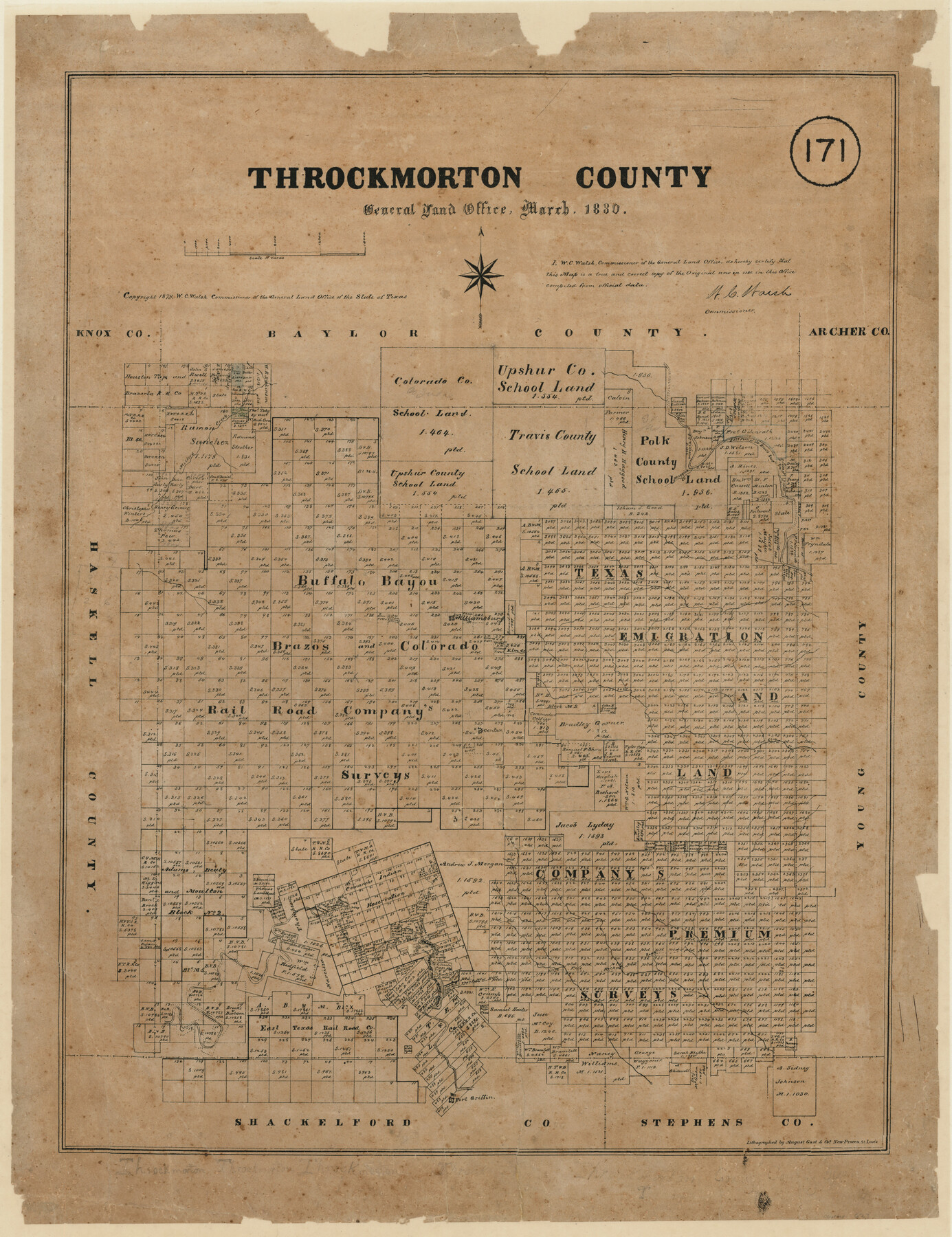
Throckmorton County, Texas
-
Map/Doc
627
-
Collection
Maddox Collection
-
Object Dates
3/1880 (Creation Date)
1879 (Copyright Date)
-
People and Organizations
General Land Office (Publisher)
W.C. Walsh (GLO Commissioner)
August Gast & Co. (Lithographer)
-
Counties
Throckmorton
-
Subjects
County
-
Height x Width
28.8 x 22.5 inches
73.2 x 57.2 cm
-
Medium
paper, etching/engraving/lithograph
-
Scale
1" = 4000 varas
-
Comments
Conservation funded in 2011 by Friends of the Texas General Land Office.
-
Features
Salt Fork of the Brazos River
Muggins Creek
Millers Creek
Williamsburg
Elm Creek
Hog Creek
Old Camp Cooper
Pond Creek
Bobtay's [?] Creek
Phantom Hill and Fort Belknap Road
Phantom Hill Road
Fort Belknap Road
Fort Griffin
Clear Fork of the Brazos River
Part of: Maddox Collection
Map of survey made for Ingham S. Roberts on Application No. 147, SF-9177 containing 413.78 acres, 4 mi SE of Houston, Harris Co. Texas

Print $20.00
- Digital $50.00
Map of survey made for Ingham S. Roberts on Application No. 147, SF-9177 containing 413.78 acres, 4 mi SE of Houston, Harris Co. Texas
1910
Size 37.3 x 31.0 inches
Map/Doc 373
Map of surveys 191 & 192 T. C. R.R. Co. in Travis County, Texas

Print $20.00
- Digital $50.00
Map of surveys 191 & 192 T. C. R.R. Co. in Travis County, Texas
1915
Size 20.7 x 12.9 inches
Map/Doc 75555
Childress County, Texas

Print $20.00
- Digital $50.00
Childress County, Texas
1890
Size 19.9 x 16.9 inches
Map/Doc 673
Map of Anderson County, Texas

Print $20.00
- Digital $50.00
Map of Anderson County, Texas
1879
Size 18.5 x 21.7 inches
Map/Doc 377
Mitchell County, Texas

Print $20.00
- Digital $50.00
Mitchell County, Texas
1870
Size 22.7 x 18.0 inches
Map/Doc 741
[Surveying Sketch of Mrs. S. C. Alexander, Vicente Salines, J. P. Blessington, et al in Sutton County, Texas]
![75765, [Surveying Sketch of Mrs. S. C. Alexander, Vicente Salines, J. P. Blessington, et al in Sutton County, Texas], Maddox Collection](https://historictexasmaps.com/wmedia_w700/maps/75765.tif.jpg)
Print $20.00
- Digital $50.00
[Surveying Sketch of Mrs. S. C. Alexander, Vicente Salines, J. P. Blessington, et al in Sutton County, Texas]
Size 19.3 x 21.0 inches
Map/Doc 75765
Montgomery County, Texas

Print $20.00
- Digital $50.00
Montgomery County, Texas
1880
Size 24.6 x 27.6 inches
Map/Doc 582
Map of Surveys 6, 7, & 8, Block 1, D.B. Gardner 7 1/2, Block L, D.B. Gardner 7, Block T, J.P. Goen

Print $20.00
- Digital $50.00
Map of Surveys 6, 7, & 8, Block 1, D.B. Gardner 7 1/2, Block L, D.B. Gardner 7, Block T, J.P. Goen
1917
Size 11.0 x 22.6 inches
Map/Doc 10762
Sketch of Garza Co.

Print $3.00
- Digital $50.00
Sketch of Garza Co.
1884
Size 12.3 x 10.2 inches
Map/Doc 468
Map of Runnels County, Texas

Print $20.00
- Digital $50.00
Map of Runnels County, Texas
1879
Size 28.8 x 22.0 inches
Map/Doc 5035
Topography and water depth as shown by the U.S. Coast Survey of 1888

Print $20.00
- Digital $50.00
Topography and water depth as shown by the U.S. Coast Survey of 1888
1890
Size 17.0 x 18.8 inches
Map/Doc 390
Shelby County, Texas

Print $20.00
- Digital $50.00
Shelby County, Texas
1880
Size 22.8 x 28.5 inches
Map/Doc 617
You may also like
Leon County Rolled Sketch 15

Print $20.00
- Digital $50.00
Leon County Rolled Sketch 15
1979
Size 23.5 x 18.9 inches
Map/Doc 6601
University of Texas System University Lands

Print $20.00
- Digital $50.00
University of Texas System University Lands
1937
Size 23.3 x 17.6 inches
Map/Doc 93237
Flight Mission No. CRC-6R, Frame 38, Chambers County

Print $20.00
- Digital $50.00
Flight Mission No. CRC-6R, Frame 38, Chambers County
1956
Size 18.7 x 22.4 inches
Map/Doc 84971
Nueces County NRC Article 33.136 Sketch 3

Print $68.00
- Digital $50.00
Nueces County NRC Article 33.136 Sketch 3
2002
Size 24.7 x 36.5 inches
Map/Doc 87922
Flight Mission No. DQO-8K, Frame 54, Galveston County

Print $20.00
- Digital $50.00
Flight Mission No. DQO-8K, Frame 54, Galveston County
1952
Size 18.5 x 22.2 inches
Map/Doc 85161
Coleman County

Print $40.00
- Digital $50.00
Coleman County
1945
Size 54.7 x 37.1 inches
Map/Doc 73109
[Blocks M18, M23, I, Z, and Block 47, Sections 16-28]
![91244, [Blocks M18, M23, I, Z, and Block 47, Sections 16-28], Twichell Survey Records](https://historictexasmaps.com/wmedia_w700/maps/91244-1.tif.jpg)
Print $20.00
- Digital $50.00
[Blocks M18, M23, I, Z, and Block 47, Sections 16-28]
Size 19.5 x 23.6 inches
Map/Doc 91244
Pecos County Sketch File 27B

Print $20.00
- Digital $50.00
Pecos County Sketch File 27B
1908
Size 25.7 x 20.8 inches
Map/Doc 12167
Ennis, Ellis County, Texas

Print $20.00
- Digital $50.00
Ennis, Ellis County, Texas
1934
Size 34.6 x 22.9 inches
Map/Doc 4826
San Patricio County Rolled Sketch 31

Print $20.00
- Digital $50.00
San Patricio County Rolled Sketch 31
1941
Size 43.1 x 42.6 inches
Map/Doc 9898
Jefferson County Working Sketch 35

Print $20.00
- Digital $50.00
Jefferson County Working Sketch 35
1982
Size 39.1 x 32.6 inches
Map/Doc 66579
Map of Texas and the countries adjacent compiled in the Bureau of the Corps of Topographical Engineers from the best authorities for the State Department

Print $20.00
- Digital $50.00
Map of Texas and the countries adjacent compiled in the Bureau of the Corps of Topographical Engineers from the best authorities for the State Department
1844
Size 25.9 x 18.2 inches
Map/Doc 72714