Reagan County Sketch File 15
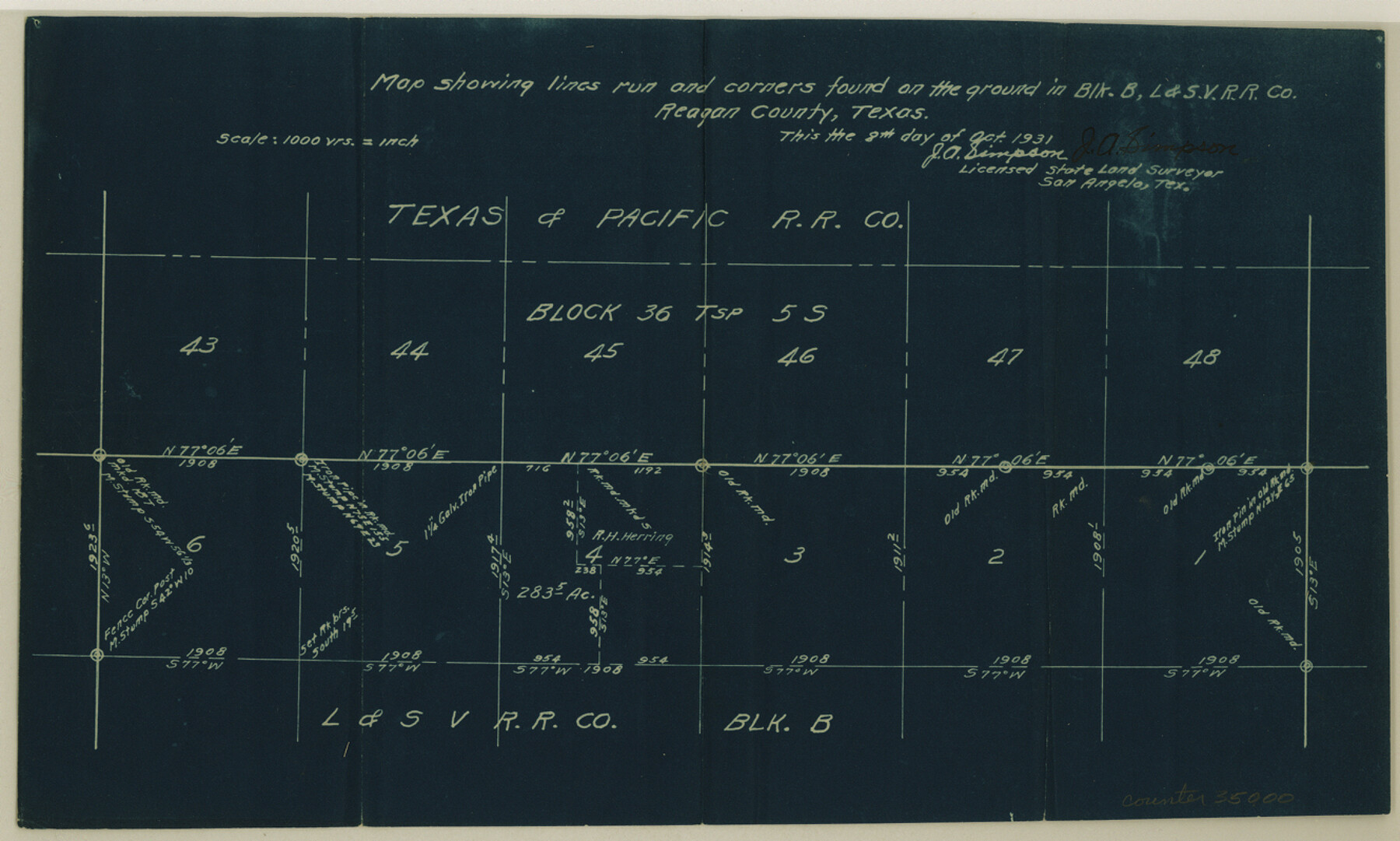
Map showing lines run and corners found on the ground in Block B, L. & S. V. RR. Co.
-
Map/Doc
35000
-
Collection
General Map Collection
-
Object Dates
1931/10/8 (Creation Date)
1931/10/28 (File Date)
-
People and Organizations
J.A. Simpson (Surveyor/Engineer)
-
Counties
Reagan
-
Subjects
Surveying Sketch File
-
Height x Width
8.0 x 13.3 inches
20.3 x 33.8 cm
-
Medium
blueprint/diazo
-
Scale
1" = 1000 varas
Part of: General Map Collection
Leon County Sketch File 2

Print $4.00
- Digital $50.00
Leon County Sketch File 2
1852
Size 8.1 x 5.1 inches
Map/Doc 29711
San Jacinto County Working Sketch 27

Print $20.00
- Digital $50.00
San Jacinto County Working Sketch 27
1944
Size 30.5 x 23.3 inches
Map/Doc 63740
Overlay For BRE-1P, Frame 153 of Refugio Scrip 1930, Nueces County

Print $20.00
- Digital $50.00
Overlay For BRE-1P, Frame 153 of Refugio Scrip 1930, Nueces County
1956
Size 18.8 x 22.6 inches
Map/Doc 86713
Clay County Working Sketch 1

Print $20.00
- Digital $50.00
Clay County Working Sketch 1
Size 30.7 x 29.3 inches
Map/Doc 68024
Real County Rolled Sketch 18

Print $20.00
- Digital $50.00
Real County Rolled Sketch 18
Size 22.2 x 28.2 inches
Map/Doc 7461
[Sketch for Mineral Application 16777]
![65655, [Sketch for Mineral Application 16777], General Map Collection](https://historictexasmaps.com/wmedia_w700/maps/65655-1.tif.jpg)
Print $40.00
- Digital $50.00
[Sketch for Mineral Application 16777]
Size 19.8 x 80.3 inches
Map/Doc 65655
Jim Hogg County Working Sketch 2

Print $20.00
- Digital $50.00
Jim Hogg County Working Sketch 2
1933
Size 41.2 x 29.3 inches
Map/Doc 66588
Hudspeth County Rolled Sketch 75

Print $40.00
- Digital $50.00
Hudspeth County Rolled Sketch 75
1992
Size 35.6 x 48.9 inches
Map/Doc 9238
Sterling County Rolled Sketch 24

Print $20.00
- Digital $50.00
Sterling County Rolled Sketch 24
Size 25.8 x 19.6 inches
Map/Doc 7850
Current Miscellaneous File 20

Print $22.00
- Digital $50.00
Current Miscellaneous File 20
1952
Size 10.7 x 8.1 inches
Map/Doc 73855
Tarrant County Sketch File 4

Print $4.00
- Digital $50.00
Tarrant County Sketch File 4
1856
Size 11.8 x 8.9 inches
Map/Doc 37678
Houston County Sketch File 4

Print $24.00
- Digital $50.00
Houston County Sketch File 4
1859
Size 12.7 x 8.3 inches
Map/Doc 26751
You may also like
Brazos River, Brazos River Sheet 3

Print $20.00
- Digital $50.00
Brazos River, Brazos River Sheet 3
1926
Size 21.3 x 36.0 inches
Map/Doc 78266
Hutchinson County Rolled Sketch 44-13

Print $20.00
- Digital $50.00
Hutchinson County Rolled Sketch 44-13
2002
Size 24.0 x 36.0 inches
Map/Doc 77549
Brewster County Rolled Sketch 101

Print $40.00
- Digital $50.00
Brewster County Rolled Sketch 101
1927
Size 74.7 x 50.4 inches
Map/Doc 10649
Val Verde County Working Sketch 75

Print $40.00
- Digital $50.00
Val Verde County Working Sketch 75
1971
Size 31.4 x 49.2 inches
Map/Doc 72210
Panola County

Print $20.00
- Digital $50.00
Panola County
1947
Size 40.8 x 40.3 inches
Map/Doc 66969
State of Texas

Print $40.00
- Digital $50.00
State of Texas
1985
Size 50.0 x 53.6 inches
Map/Doc 2486
No. 2 Chart of Corpus Christi Pass, Texas

Print $20.00
- Digital $50.00
No. 2 Chart of Corpus Christi Pass, Texas
1878
Size 18.3 x 27.3 inches
Map/Doc 73014
Gaines County, Texas

Print $40.00
- Digital $50.00
Gaines County, Texas
Size 60.0 x 31.3 inches
Map/Doc 89684
Hardin County Rolled Sketch 21

Print $20.00
- Digital $50.00
Hardin County Rolled Sketch 21
1966
Size 18.8 x 22.7 inches
Map/Doc 6090
Gregg County Sketch File 10

Print $20.00
- Digital $50.00
Gregg County Sketch File 10
1932
Size 35.1 x 26.0 inches
Map/Doc 11588
Harrison County Rolled Sketch 13

Print $20.00
- Digital $50.00
Harrison County Rolled Sketch 13
1967
Size 32.5 x 28.3 inches
Map/Doc 6156
Bexar County Sketch File 31

Print $40.00
- Digital $50.00
Bexar County Sketch File 31
1867
Size 11.3 x 16.4 inches
Map/Doc 10920