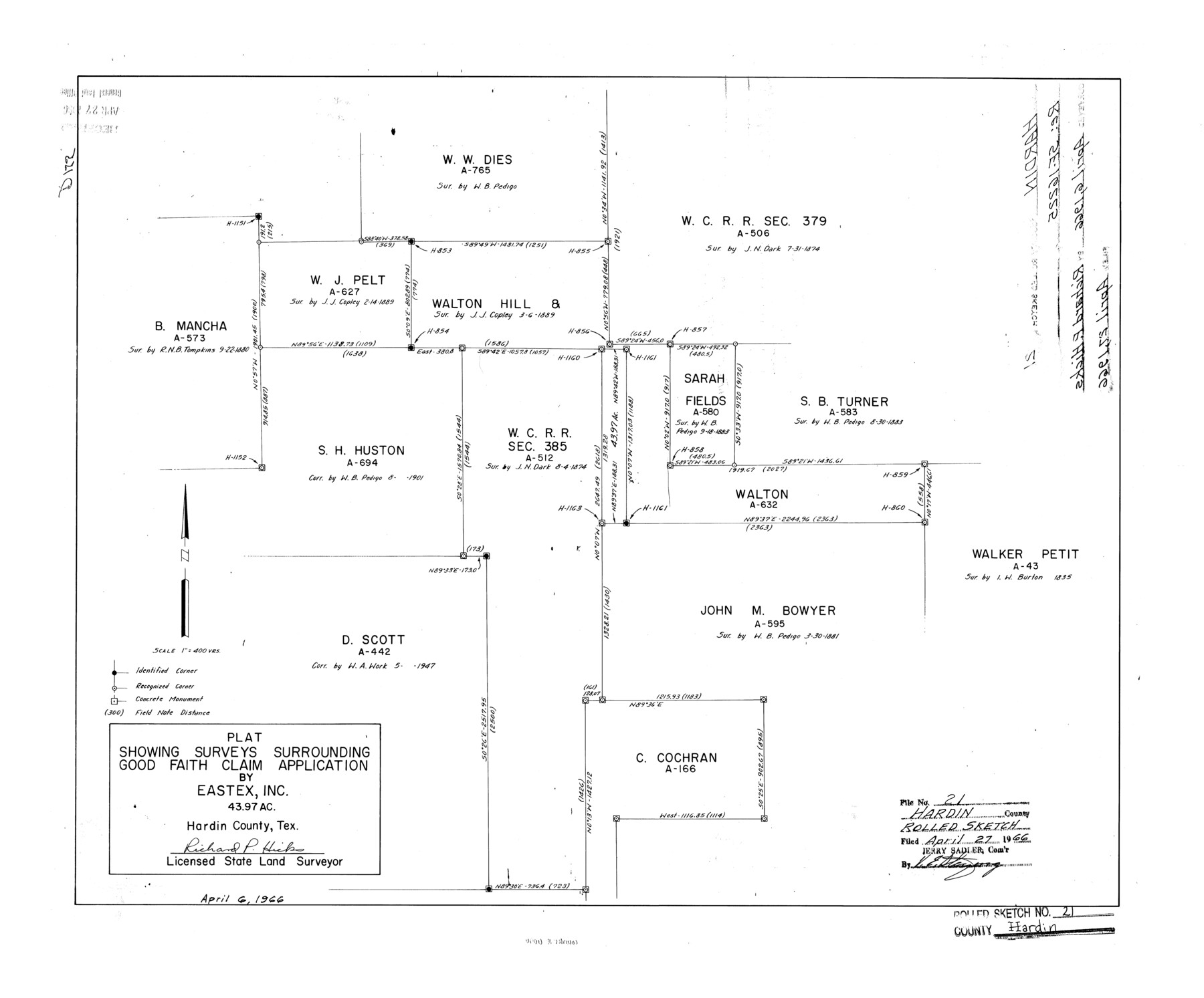
Hardin County Rolled Sketch 21
Plat showing surveys surrounding good faith claim application by Eastex, Inc., 43.97 ac.
-
Map/Doc
6090
-
Collection
General Map Collection
-
Object Dates
1966/4/6 (Creation Date)
1966/4/27 (File Date)
-
People and Organizations
Richard P. Hicks (Surveyor/Engineer)
-
Counties
Hardin
-
Subjects
Surveying Rolled Sketch
-
Height x Width
18.8 x 22.7 inches
47.8 x 57.7 cm
-
Scale
1" = 400 varas
Part of: General Map Collection
Llano County Working Sketch 1

Print $20.00
- Digital $50.00
Llano County Working Sketch 1
1938
Size 19.5 x 19.2 inches
Map/Doc 70619
Potter County Rolled Sketch 11

Print $20.00
- Digital $50.00
Potter County Rolled Sketch 11
1986
Size 21.6 x 27.4 inches
Map/Doc 7324
Edwards County Sketch File 14

Print $24.00
- Digital $50.00
Edwards County Sketch File 14
1891
Size 12.9 x 8.7 inches
Map/Doc 21703
Liberty County Sketch File 16

Print $4.00
- Digital $50.00
Liberty County Sketch File 16
1859
Size 11.4 x 6.7 inches
Map/Doc 29917
Atascosa County Working Sketch 12

Print $20.00
- Digital $50.00
Atascosa County Working Sketch 12
1926
Size 23.0 x 29.2 inches
Map/Doc 67208
Galveston County Sketch File 5

Print $4.00
- Digital $50.00
Galveston County Sketch File 5
1848
Size 8.6 x 9.0 inches
Map/Doc 23358
Flight Mission No. DQO-1K, Frame 115, Galveston County

Print $20.00
- Digital $50.00
Flight Mission No. DQO-1K, Frame 115, Galveston County
1952
Size 18.9 x 22.5 inches
Map/Doc 84993
Atascosa County Rolled Sketch 8

Print $20.00
- Digital $50.00
Atascosa County Rolled Sketch 8
1942
Size 34.8 x 41.9 inches
Map/Doc 8427

Flight Mission No. CGI-4N, Frame 162, Cameron County

Print $20.00
- Digital $50.00
Flight Mission No. CGI-4N, Frame 162, Cameron County
1955
Size 18.7 x 22.5 inches
Map/Doc 84670
Trinity River, Oliver Crossing Sheet/Chambers Creek

Print $6.00
- Digital $50.00
Trinity River, Oliver Crossing Sheet/Chambers Creek
1931
Size 30.1 x 28.2 inches
Map/Doc 65231
Montgomery County Sketch File 18

Print $20.00
- Digital $50.00
Montgomery County Sketch File 18
1899
Size 22.1 x 19.6 inches
Map/Doc 42122
You may also like
Flight Mission No. BRA-8M, Frame 27, Jefferson County

Print $20.00
- Digital $50.00
Flight Mission No. BRA-8M, Frame 27, Jefferson County
1953
Size 18.6 x 22.3 inches
Map/Doc 85582
Montgomery County Working Sketch 12

Print $20.00
- Digital $50.00
Montgomery County Working Sketch 12
1933
Size 32.5 x 31.9 inches
Map/Doc 71119
Bee County Sketch File 11

Print $40.00
- Digital $50.00
Bee County Sketch File 11
Size 20.8 x 25.0 inches
Map/Doc 10915
Colorado River, Grape Creek Sheet/Proposed Dam Site

Print $4.00
- Digital $50.00
Colorado River, Grape Creek Sheet/Proposed Dam Site
1937
Size 20.1 x 23.8 inches
Map/Doc 65304
Carte Générale du Royaume de la Nouvelle Espagne depuis le Parallele de 16° jusqu'au Parallele de 38° (Latitude Nord) dressée sur des Observations Astronomiques et sur l'ensemble des Matériaux qui existoient à Mexico, au commencement de l'année 1804

Print $20.00
- Digital $50.00
Carte Générale du Royaume de la Nouvelle Espagne depuis le Parallele de 16° jusqu'au Parallele de 38° (Latitude Nord) dressée sur des Observations Astronomiques et sur l'ensemble des Matériaux qui existoient à Mexico, au commencement de l'année 1804
1809
Size 21.6 x 32.5 inches
Map/Doc 93782
Flight Mission No. CRK-5P, Frame 153, Refugio County

Print $20.00
- Digital $50.00
Flight Mission No. CRK-5P, Frame 153, Refugio County
1956
Size 18.4 x 22.3 inches
Map/Doc 86934
Kimble County Rolled Sketch 28

Print $20.00
- Digital $50.00
Kimble County Rolled Sketch 28
1964
Size 19.7 x 20.6 inches
Map/Doc 6518
Map of Blue Creek Ranch in Moore County, Texas

Print $20.00
- Digital $50.00
Map of Blue Creek Ranch in Moore County, Texas
Size 15.1 x 13.8 inches
Map/Doc 91420
Township No. 6 South Range No. 8 West of the Indian Meridian

Print $20.00
- Digital $50.00
Township No. 6 South Range No. 8 West of the Indian Meridian
1874
Size 19.2 x 24.4 inches
Map/Doc 75155
Map of the State of Coahuila and Texas

Print $20.00
- Digital $50.00
Map of the State of Coahuila and Texas
1834
Size 13.2 x 14.7 inches
Map/Doc 93848
Brewster County Rolled Sketch 114

Print $20.00
- Digital $50.00
Brewster County Rolled Sketch 114
1964
Size 11.5 x 17.5 inches
Map/Doc 5287
[Sections 55-58, Blk. GG and surrounding surveys]
![90319, [Sections 55-58, Blk. GG and surrounding surveys], Twichell Survey Records](https://historictexasmaps.com/wmedia_w700/maps/90319-1.tif.jpg)
Print $20.00
- Digital $50.00
[Sections 55-58, Blk. GG and surrounding surveys]
Size 41.1 x 29.7 inches
Map/Doc 90319