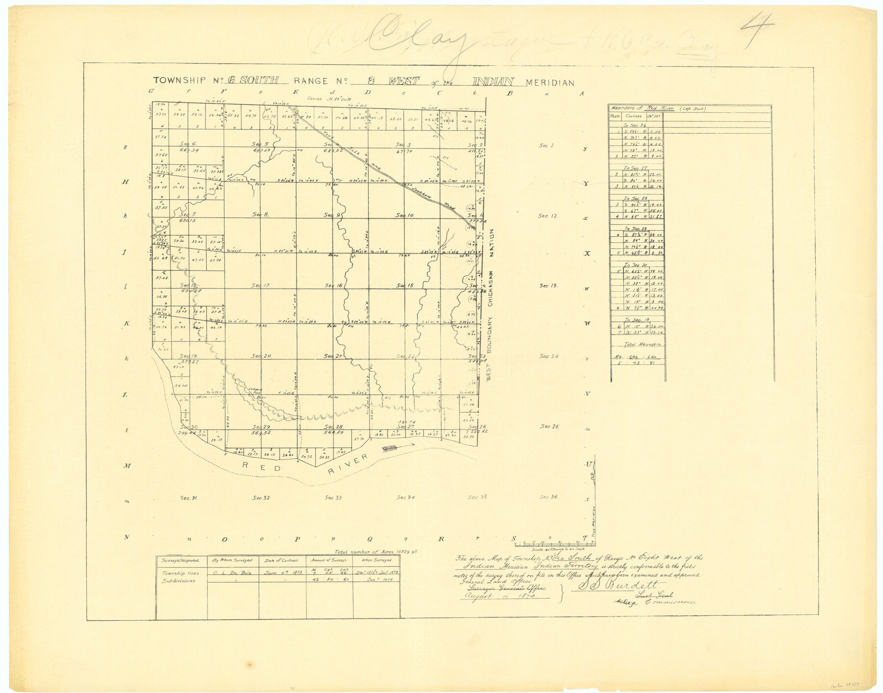
Township No. 6 South Range No. 8 West of the Indian Meridian
-
Map/Doc
75155
-
Collection
General Map Collection
-
Object Dates
1874 (Creation Date)
-
Subjects
Texas Boundaries
-
Height x Width
19.2 x 24.4 inches
48.8 x 62.0 cm
Part of: General Map Collection
United States - Gulf Coast Texas - Northern part of Laguna Madre

Print $20.00
- Digital $50.00
United States - Gulf Coast Texas - Northern part of Laguna Madre
1923
Size 26.7 x 18.3 inches
Map/Doc 72932
Fisher County Sketch File 24

Print $37.00
- Digital $50.00
Fisher County Sketch File 24
1875
Size 14.3 x 8.9 inches
Map/Doc 22666
Cass County Working Sketch 32

Print $20.00
- Digital $50.00
Cass County Working Sketch 32
1982
Size 24.0 x 22.6 inches
Map/Doc 67935
Flight Mission No. BRA-3M, Frame 195, Jefferson County

Print $20.00
- Digital $50.00
Flight Mission No. BRA-3M, Frame 195, Jefferson County
1953
Size 18.6 x 22.3 inches
Map/Doc 85410
Rains County Boundary File 1

Print $6.00
- Digital $50.00
Rains County Boundary File 1
Size 11.3 x 8.8 inches
Map/Doc 58090
Donley County

Print $20.00
- Digital $50.00
Donley County
1944
Size 46.8 x 40.6 inches
Map/Doc 95484
Sutton County Sketch File 36a

Print $61.00
- Digital $50.00
Sutton County Sketch File 36a
Size 9.0 x 9.0 inches
Map/Doc 37472
Bosque County Sketch File 25

Print $4.00
- Digital $50.00
Bosque County Sketch File 25
Size 12.7 x 8.1 inches
Map/Doc 14809
Lipscomb County Rolled Sketch 2

Print $20.00
- Digital $50.00
Lipscomb County Rolled Sketch 2
1886
Size 24.1 x 30.2 inches
Map/Doc 6628
Glasscock County Working Sketch 11

Print $40.00
- Digital $50.00
Glasscock County Working Sketch 11
1957
Size 87.4 x 36.2 inches
Map/Doc 63184
Martin County

Print $20.00
- Digital $50.00
Martin County
1933
Size 38.9 x 34.0 inches
Map/Doc 77366
Flight Mission No. BRA-16M, Frame 91, Jefferson County

Print $20.00
- Digital $50.00
Flight Mission No. BRA-16M, Frame 91, Jefferson County
1953
Size 18.7 x 22.5 inches
Map/Doc 85703
You may also like
Galveston County Working Sketch 13

Print $20.00
- Digital $50.00
Galveston County Working Sketch 13
1975
Size 23.1 x 16.7 inches
Map/Doc 69350
[I. & G. N. Sections 11, 12, and 13]
![91038, [I. & G. N. Sections 11, 12, and 13], Twichell Survey Records](https://historictexasmaps.com/wmedia_w700/maps/91038-1.tif.jpg)
Print $20.00
- Digital $50.00
[I. & G. N. Sections 11, 12, and 13]
Size 28.9 x 11.5 inches
Map/Doc 91038
Blanco County Working Sketch 1

Print $20.00
- Digital $50.00
Blanco County Working Sketch 1
Size 31.1 x 17.4 inches
Map/Doc 76449
General Highway Map, Yoakum County, Texas

Print $20.00
General Highway Map, Yoakum County, Texas
1961
Size 18.2 x 24.7 inches
Map/Doc 79719
PSL Field Notes for Block JKL in Hudspeth County

PSL Field Notes for Block JKL in Hudspeth County
Map/Doc 81658
Trinity River, Onion Creek Station Sheet/Chambers Creek

Print $6.00
- Digital $50.00
Trinity River, Onion Creek Station Sheet/Chambers Creek
1931
Size 35.1 x 32.4 inches
Map/Doc 65234
Duval County Rolled Sketch 34

Print $20.00
- Digital $50.00
Duval County Rolled Sketch 34
1951
Size 24.3 x 37.6 inches
Map/Doc 5749
Sketch of a part of Galveston Island

Print $3.00
- Digital $50.00
Sketch of a part of Galveston Island
Size 10.8 x 13.8 inches
Map/Doc 430
Harris County NRC Article 33.136 Sketch 7

Print $20.00
- Digital $50.00
Harris County NRC Article 33.136 Sketch 7
2004
Size 24.3 x 18.5 inches
Map/Doc 82991
Map of survey Nos. 2, 14, 12 & 20, A. & N. W. R.R. Co. and connections

Print $20.00
- Digital $50.00
Map of survey Nos. 2, 14, 12 & 20, A. & N. W. R.R. Co. and connections
1904
Size 16.9 x 32.7 inches
Map/Doc 75811
Lindner Subdivision out of the Baker Subdivision of the Cucharia Tract being Lots 11 and 14, San Salvador del Tule Grant Hidalgo Co. Texas and also showing the Ehlert-Krausse Sub. and the Townsite of Alsonia

Print $20.00
- Digital $50.00
Lindner Subdivision out of the Baker Subdivision of the Cucharia Tract being Lots 11 and 14, San Salvador del Tule Grant Hidalgo Co. Texas and also showing the Ehlert-Krausse Sub. and the Townsite of Alsonia
1927
Size 22.3 x 35.3 inches
Map/Doc 77093
[Worksheets related to the Wilson Strickland survey and vicinity]
![91383, [Worksheets related to the Wilson Strickland survey and vicinity], Twichell Survey Records](https://historictexasmaps.com/wmedia_w700/maps/91383-1.tif.jpg)
Print $20.00
- Digital $50.00
[Worksheets related to the Wilson Strickland survey and vicinity]
Size 36.0 x 15.7 inches
Map/Doc 91383