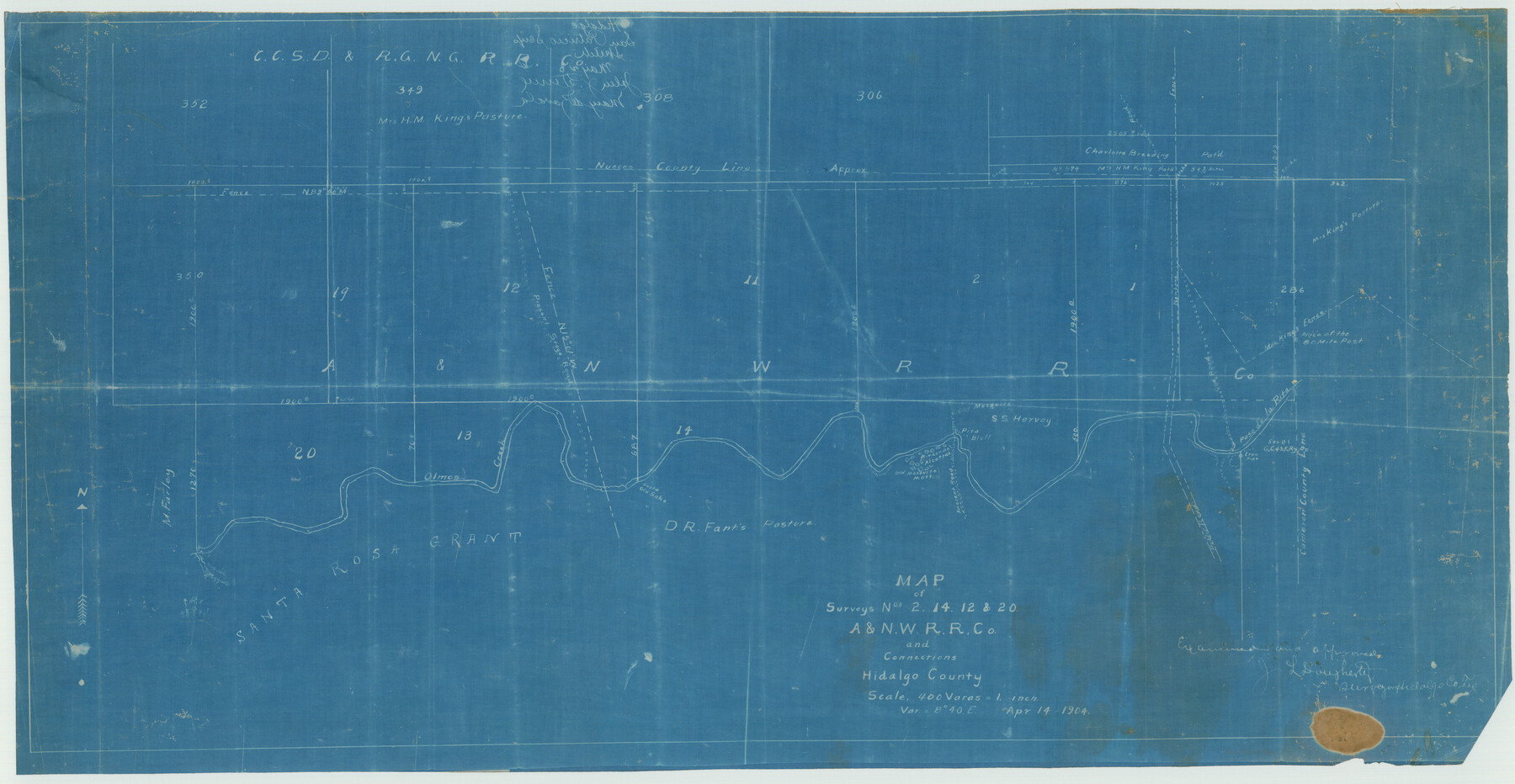
Map of survey Nos. 2, 14, 12 & 20, A. & N. W. R.R. Co. and connections
-
Map/Doc
75811
-
Collection
Maddox Collection
-
Object Dates
1904/4/14 (Creation Date)
-
Counties
Hidalgo Nueces Cameron Kleberg
-
Height x Width
16.9 x 32.7 inches
42.9 x 83.1 cm
-
Medium
blueprint/diazo
-
Scale
400 varas = 1 inch
-
Comments
Map refers to Hidalgo, Nueces, and Cameron Counties, but is in present day Kleberg County.
-
Features
[Los] Olmos Creek
Paso de la Pita
Ancient Road
Pita Bluff
Old Mesquite Mott
Rincon del Alcatraz
Present Stage Road
Public Road
Part of: Maddox Collection
Map of Bowie County, Texas

Print $20.00
- Digital $50.00
Map of Bowie County, Texas
1879
Size 21.2 x 24.4 inches
Map/Doc 607
Map of Menard County, Texas

Print $20.00
- Digital $50.00
Map of Menard County, Texas
1879
Size 18.5 x 24.8 inches
Map/Doc 580
Foard County, Texas

Print $20.00
- Digital $50.00
Foard County, Texas
1891
Size 19.5 x 20.7 inches
Map/Doc 727
[Longview and Sabine Valley Railway Company Blocks in Reagan & Upton Counties, Texas]
![75789, [Longview and Sabine Valley Railway Company Blocks in Reagan & Upton Counties, Texas], Maddox Collection](https://historictexasmaps.com/wmedia_w700/maps/75789.tif.jpg)
Print $20.00
- Digital $50.00
[Longview and Sabine Valley Railway Company Blocks in Reagan & Upton Counties, Texas]
Size 17.5 x 18.3 inches
Map/Doc 75789
Coryell County, Texas

Print $20.00
- Digital $50.00
Coryell County, Texas
1879
Size 23.5 x 29.1 inches
Map/Doc 704
Map of Bexar County, Texas

Print $20.00
- Digital $50.00
Map of Bexar County, Texas
1879
Size 25.1 x 29.7 inches
Map/Doc 530
Midland County, Texas

Print $20.00
- Digital $50.00
Midland County, Texas
1888
Size 22.4 x 17.5 inches
Map/Doc 653
Wichita County

Print $20.00
- Digital $50.00
Wichita County
1892
Size 20.2 x 24.3 inches
Map/Doc 75804
Saline Ranch in Mason, Kimble and Menard Counties

Print $20.00
- Digital $50.00
Saline Ranch in Mason, Kimble and Menard Counties
1916
Size 28.3 x 27.2 inches
Map/Doc 75806
Map of Townsite of Swearingen, Cottle County, Texas

Print $20.00
- Digital $50.00
Map of Townsite of Swearingen, Cottle County, Texas
1918
Size 28.8 x 17.4 inches
Map/Doc 4464
Map of Kinney County, Texas

Print $20.00
- Digital $50.00
Map of Kinney County, Texas
1879
Size 21.2 x 33.1 inches
Map/Doc 548
[Sketch of Surveys Near Port Aransas and Aransas Pass, Aransas County, Texas]
![676, [Sketch of Surveys Near Port Aransas and Aransas Pass, Aransas County, Texas], Maddox Collection](https://historictexasmaps.com/wmedia_w700/maps/676.tif.jpg)
Print $20.00
- Digital $50.00
[Sketch of Surveys Near Port Aransas and Aransas Pass, Aransas County, Texas]
Size 22.8 x 18.5 inches
Map/Doc 676
You may also like

Hamilton County Sketch File 14

Print $10.00
- Digital $50.00
Hamilton County Sketch File 14
Size 10.1 x 8.0 inches
Map/Doc 24937
Section 160, Block G, Gaines County, Texas

Print $20.00
- Digital $50.00
Section 160, Block G, Gaines County, Texas
1958
Size 17.1 x 19.3 inches
Map/Doc 92679
Flight Mission No. BRA-16M, Frame 141, Jefferson County

Print $20.00
- Digital $50.00
Flight Mission No. BRA-16M, Frame 141, Jefferson County
1953
Size 18.6 x 22.2 inches
Map/Doc 85747
Galveston County Rolled Sketch 27A

Print $20.00
- Digital $50.00
Galveston County Rolled Sketch 27A
1978
Size 32.2 x 35.5 inches
Map/Doc 5962
Atascosa County Boundary File 6

Print $34.00
- Digital $50.00
Atascosa County Boundary File 6
Size 9.1 x 23.0 inches
Map/Doc 50205
Right of Way and Track Map, International & Gt. Northern Ry. Operated by the International & Gt. Northern Ry. Co., Gulf Division

Print $40.00
- Digital $50.00
Right of Way and Track Map, International & Gt. Northern Ry. Operated by the International & Gt. Northern Ry. Co., Gulf Division
1917
Size 25.1 x 56.6 inches
Map/Doc 64252
Gray County Sketch File B3

Print $8.00
- Digital $50.00
Gray County Sketch File B3
1880
Size 13.0 x 8.5 inches
Map/Doc 24411
Kinney County Working Sketch 3

Print $20.00
- Digital $50.00
Kinney County Working Sketch 3
Size 20.3 x 17.6 inches
Map/Doc 70185
Menard County Sketch File 10

Print $20.00
- Digital $50.00
Menard County Sketch File 10
1885
Size 32.5 x 18.0 inches
Map/Doc 12074
Reeves County Rolled Sketch 2

Print $20.00
- Digital $50.00
Reeves County Rolled Sketch 2
1890
Size 34.0 x 39.5 inches
Map/Doc 9845
Flight Mission No. DQN-6K, Frame 69, Calhoun County

Print $20.00
- Digital $50.00
Flight Mission No. DQN-6K, Frame 69, Calhoun County
1953
Size 18.6 x 22.1 inches
Map/Doc 84441