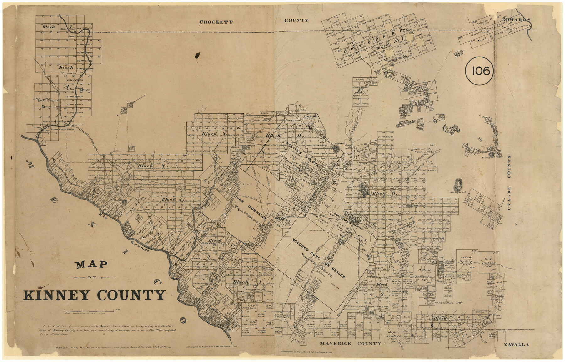
Map of Kinney County, Texas
-
Map/Doc
548
-
Collection
Maddox Collection
-
Object Dates
1879 (Creation Date)
-
People and Organizations
General Land Office (Publisher)
August Gast & Co. (Lithographer)
-
Counties
Kinney
-
Subjects
County
-
Height x Width
21.2 x 33.1 inches
53.9 x 84.1 cm
-
Medium
paper, etching/engraving/lithograph
-
Scale
1" = 4000 varas
-
Comments
Conservation funded in 2009.
-
Features
Pisaro Pinto Creek
Mud Creek
El Paso Road
Sycamore Creek
Las Manos Mountain
Olmos Mountain
Turkey Cr[eek] Mountain
W[est] P[rong] of Nueces [River]
Fort Clark
Bracckett [sic]
Sycamore Creek
Sacatose Creek
Rio Grande
Gladesburg
Las Moras Creek
Stage Stand [on El Paso Road]
Elm Creek
Lindsay Creek
Cow Creek
Salado Creek
Chaparosa Creek
Lower Pinto Creek
E[ast] P[rong] of San Pedro Arroyo
Onion Creek
Seneguas Creek
West [Pinto Creek]
Ellipsis Mountain
Griffin Creek
Lone Hill
W[est] F[ork] of Painted Cape Creek
Live Oak Creek
[Road] to Griffin Valley
Maverick Creek
Devil's River
[Road] to Fort Lancaster and Camp Hudson
Road to Fort Lancaster
Road to Camp Hudson
Sinegas Creek
Pinto Mountain
West Fork of Nueces River
Grass Valley Creek
[Road] to Nueces River and Fort McKavitt
Road to Nueces River
Road to Fort McKavitt
Bluff Creek
Little Pinto Mountain
East Pinto Creek
Big Perdido [Creek]
Little Perdido Creek
San Felipe
Conical Hill
Part of: Maddox Collection
Gillespie County, Texas

Print $20.00
- Digital $50.00
Gillespie County, Texas
1879
Size 21.2 x 26.9 inches
Map/Doc 547
[Plat Showing Colorado, Upshur & Travis County School Land and Surrounding Area in Baylor & Throckmorton Counties, Texas]
![75790, [Plat Showing Colorado, Upshur & Travis County School Land and Surrounding Area in Baylor & Throckmorton Counties, Texas], Maddox Collection](https://historictexasmaps.com/wmedia_w700/maps/75790.tif.jpg)
Print $20.00
- Digital $50.00
[Plat Showing Colorado, Upshur & Travis County School Land and Surrounding Area in Baylor & Throckmorton Counties, Texas]
1889
Size 15.8 x 20.5 inches
Map/Doc 75790
[Sketch Showing Loma Blanca and San Antonio de Encinal Leagues, Brooks County, Texas]
![4448, [Sketch Showing Loma Blanca and San Antonio de Encinal Leagues, Brooks County, Texas], Maddox Collection](https://historictexasmaps.com/wmedia_w700/maps/4448-1.tif.jpg)
Print $3.00
- Digital $50.00
[Sketch Showing Loma Blanca and San Antonio de Encinal Leagues, Brooks County, Texas]
1912
Size 15.1 x 11.4 inches
Map/Doc 4448
Austin, Texas Congress Ave. Drainage

Print $20.00
- Digital $50.00
Austin, Texas Congress Ave. Drainage
1903
Size 15.3 x 15.4 inches
Map/Doc 75798
Map of a resurvey of the land involved in the suit of Lillian-Vineyard vs. O.M. O'Connor et al (Lamar townlots excepted)

Print $20.00
- Digital $50.00
Map of a resurvey of the land involved in the suit of Lillian-Vineyard vs. O.M. O'Connor et al (Lamar townlots excepted)
1911
Size 18.8 x 17.9 inches
Map/Doc 481
King County Survey made by A.C. Tackitt and W.D. Twichell

Print $20.00
- Digital $50.00
King County Survey made by A.C. Tackitt and W.D. Twichell
1916
Size 27.5 x 25.1 inches
Map/Doc 5069
Plat Showing Position of Hancock Tract and the City of Austin

Print $20.00
- Digital $50.00
Plat Showing Position of Hancock Tract and the City of Austin
Size 22.4 x 17.5 inches
Map/Doc 599
Map of Denton County, Texas

Print $20.00
- Digital $50.00
Map of Denton County, Texas
Size 22.8 x 19.4 inches
Map/Doc 711
Sketch in Atascosa County

Print $3.00
- Digital $50.00
Sketch in Atascosa County
1890
Size 12.6 x 11.4 inches
Map/Doc 578
Map of the O-X Ranch in Cottle County, Texas
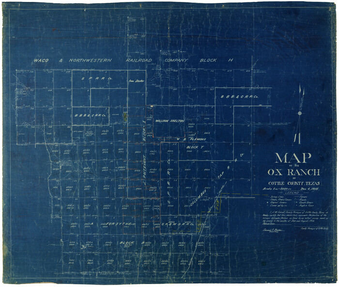
Print $20.00
- Digital $50.00
Map of the O-X Ranch in Cottle County, Texas
1916
Size 30.4 x 35.0 inches
Map/Doc 4438
[Surveying Sketch of Heirs of Wm Neil, J.J. Hall, Robert Sikes, et al in Hutchinson County, Texas]
![75778, [Surveying Sketch of Heirs of Wm Neil, J.J. Hall, Robert Sikes, et al in Hutchinson County, Texas], Maddox Collection](https://historictexasmaps.com/wmedia_w700/maps/75778-1.tif.jpg)
Print $20.00
- Digital $50.00
[Surveying Sketch of Heirs of Wm Neil, J.J. Hall, Robert Sikes, et al in Hutchinson County, Texas]
Size 15.6 x 20.5 inches
Map/Doc 75778
[Block A, Greer County, Texas]
![384, [Block A, Greer County, Texas], Maddox Collection](https://historictexasmaps.com/wmedia_w700/maps/384.tif.jpg)
Print $20.00
- Digital $50.00
[Block A, Greer County, Texas]
Size 16.9 x 15.8 inches
Map/Doc 384
You may also like

Map of the United States showing the Texas & Pacific Railway and its connections

Print $20.00
- Digital $50.00
Map of the United States showing the Texas & Pacific Railway and its connections
1875
Size 11.9 x 16.8 inches
Map/Doc 93960
Map of survey Nos. 2, 14, 12 & 20, A. & N. W. R.R. Co. and connections

Print $20.00
- Digital $50.00
Map of survey Nos. 2, 14, 12 & 20, A. & N. W. R.R. Co. and connections
1904
Size 16.9 x 32.7 inches
Map/Doc 75811
Haskell County Working Sketch 11

Print $20.00
- Digital $50.00
Haskell County Working Sketch 11
1976
Size 38.0 x 33.4 inches
Map/Doc 66069

[Blocks S2, K3, K, and S1]
![90415, [Blocks S2, K3, K, and S1], Twichell Survey Records](https://historictexasmaps.com/wmedia_w700/maps/90415-1.tif.jpg)
Print $20.00
- Digital $50.00
[Blocks S2, K3, K, and S1]
1906
Size 17.9 x 16.4 inches
Map/Doc 90415
Flight Mission No. BRA-8M, Frame 119, Jefferson County

Print $20.00
- Digital $50.00
Flight Mission No. BRA-8M, Frame 119, Jefferson County
1953
Size 18.4 x 22.2 inches
Map/Doc 85615
Sabine Pass and Lake

Print $20.00
- Digital $50.00
Sabine Pass and Lake
1973
Size 47.0 x 27.8 inches
Map/Doc 69826
Real County Working Sketch 79

Print $20.00
- Digital $50.00
Real County Working Sketch 79
1981
Size 19.8 x 22.2 inches
Map/Doc 71971
Presidio County Rolled Sketch 137

Print $20.00
- Digital $50.00
Presidio County Rolled Sketch 137
1999
Size 38.7 x 47.9 inches
Map/Doc 8352
Vicinity of San Luis Pass, Galveston Island, Texas

Print $40.00
- Digital $50.00
Vicinity of San Luis Pass, Galveston Island, Texas
1933
Size 37.1 x 57.8 inches
Map/Doc 69943
[Sketch for Mineral Application 24072, San Jacinto River]
![65600, [Sketch for Mineral Application 24072, San Jacinto River], General Map Collection](https://historictexasmaps.com/wmedia_w700/maps/65600.tif.jpg)
Print $20.00
- Digital $50.00
[Sketch for Mineral Application 24072, San Jacinto River]
1929
Size 25.0 x 18.4 inches
Map/Doc 65600