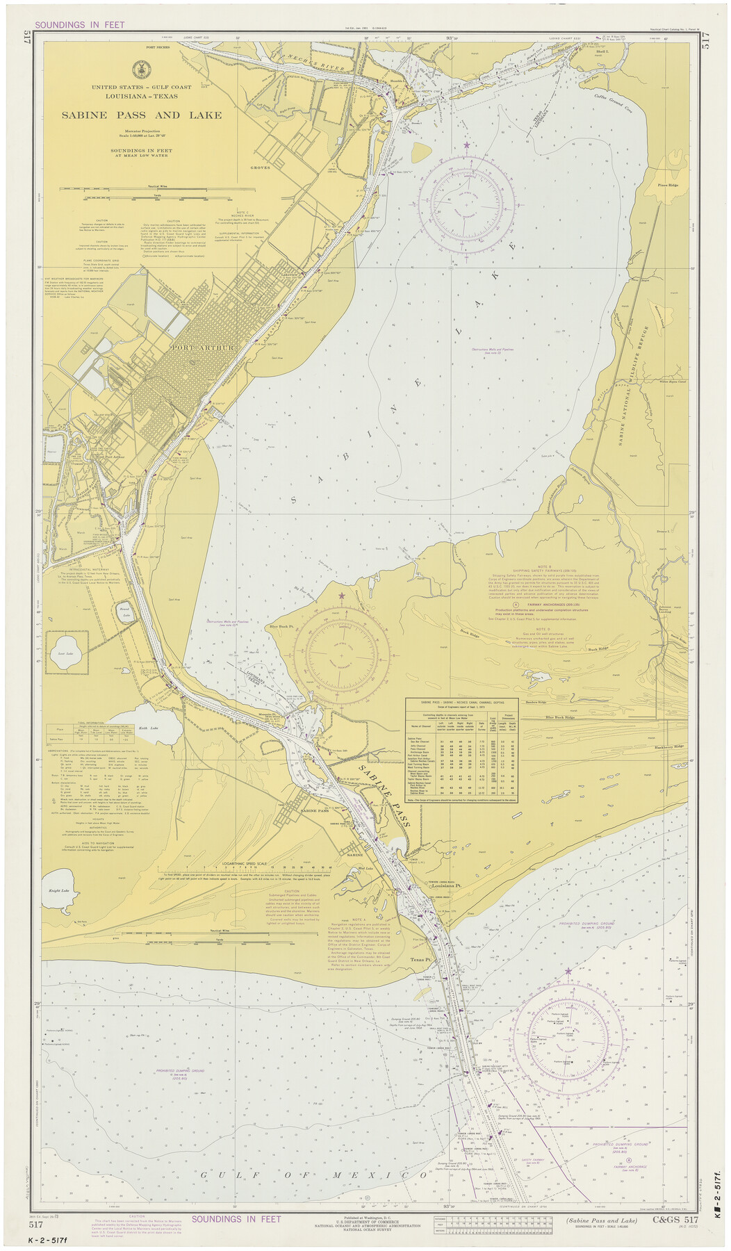
Sabine Pass and Lake
K-2-517a
-
Map/Doc
69826
-
Collection
General Map Collection
-
Object Dates
1973/9/29 (Creation Date)
-
Counties
Orange Jefferson
-
Subjects
Nautical Charts
-
Height x Width
47.0 x 27.8 inches
119.4 x 70.6 cm
Part of: General Map Collection
Zavala County Rolled Sketch 27

Print $20.00
- Digital $50.00
Zavala County Rolled Sketch 27
1955
Size 21.2 x 20.0 inches
Map/Doc 8329
Flight Mission No. BQR-20K, Frame 3, Brazoria County

Print $20.00
- Digital $50.00
Flight Mission No. BQR-20K, Frame 3, Brazoria County
1952
Size 18.6 x 22.2 inches
Map/Doc 84105
Nueces County NRC Article 33.136 Sketch 7

Print $82.00
- Digital $50.00
Nueces County NRC Article 33.136 Sketch 7
2004
Size 32.7 x 47.0 inches
Map/Doc 81932
Hall County Sketch File 33

Print $16.00
- Digital $50.00
Hall County Sketch File 33
1912
Size 11.4 x 8.7 inches
Map/Doc 24874
Montgomery County

Print $20.00
- Digital $50.00
Montgomery County
1871
Size 21.0 x 24.6 inches
Map/Doc 3891
Deaf Smith Co.

Print $40.00
- Digital $50.00
Deaf Smith Co.
1898
Size 37.2 x 48.8 inches
Map/Doc 4930
[Nueces Bay, Mustang Island and Padre Island]
![73465, [Nueces Bay, Mustang Island and Padre Island], General Map Collection](https://historictexasmaps.com/wmedia_w700/maps/73465.tif.jpg)
Print $4.00
- Digital $50.00
[Nueces Bay, Mustang Island and Padre Island]
Size 18.1 x 24.7 inches
Map/Doc 73465
Presidio County Sketch File 71

Print $10.00
- Digital $50.00
Presidio County Sketch File 71
1942
Size 11.3 x 8.8 inches
Map/Doc 34674
Upton County Working Sketch 24

Print $20.00
- Digital $50.00
Upton County Working Sketch 24
1953
Size 36.7 x 39.2 inches
Map/Doc 69520
Hutchinson County Rolled Sketch 37A

Print $40.00
- Digital $50.00
Hutchinson County Rolled Sketch 37A
1950
Size 24.6 x 50.5 inches
Map/Doc 10676
Flight Mission No. CRC-2R, Frame 4, Chambers County

Print $20.00
- Digital $50.00
Flight Mission No. CRC-2R, Frame 4, Chambers County
1956
Size 18.7 x 22.4 inches
Map/Doc 84723
Located Line of the Panhandle & Gulf Ry. through State Lands, Public School and University, in Reagan County, Texas, Right of Way 200 feet wide

Print $40.00
- Digital $50.00
Located Line of the Panhandle & Gulf Ry. through State Lands, Public School and University, in Reagan County, Texas, Right of Way 200 feet wide
1904
Size 13.4 x 90.8 inches
Map/Doc 64063
You may also like
Motley County Sketch File 6a (S)

Print $40.00
- Digital $50.00
Motley County Sketch File 6a (S)
1894
Size 14.3 x 14.4 inches
Map/Doc 32147
Map of Drum, Oyster & Bastrop Bays & vicinity in Brazoria County showing subdivision for mineral development

Print $20.00
- Digital $50.00
Map of Drum, Oyster & Bastrop Bays & vicinity in Brazoria County showing subdivision for mineral development
Size 36.8 x 47.3 inches
Map/Doc 65808
Aransas Pass to Baffin Bay

Print $20.00
- Digital $50.00
Aransas Pass to Baffin Bay
1946
Size 42.1 x 34.3 inches
Map/Doc 73412
Presidio County Sketch File 112

Print $166.00
- Digital $50.00
Presidio County Sketch File 112
1983
Size 12.1 x 31.2 inches
Map/Doc 11727
Fractional Township No. 7 South Range No. 20 East of the Indian Meridian, Indian Territory

Print $20.00
- Digital $50.00
Fractional Township No. 7 South Range No. 20 East of the Indian Meridian, Indian Territory
1897
Size 19.2 x 24.2 inches
Map/Doc 75236
Flight Mission No. DQO-3K, Frame 15, Galveston County

Print $20.00
- Digital $50.00
Flight Mission No. DQO-3K, Frame 15, Galveston County
1952
Size 18.7 x 22.4 inches
Map/Doc 85056
Map of Jefferson County

Print $20.00
- Digital $50.00
Map of Jefferson County
1840
Size 32.7 x 23.4 inches
Map/Doc 3725
Brazos River, Brazos River Sheet 8

Print $4.00
- Digital $50.00
Brazos River, Brazos River Sheet 8
1926
Size 22.6 x 29.2 inches
Map/Doc 65301
Jack County Sketch File 1

Print $4.00
- Digital $50.00
Jack County Sketch File 1
Size 8.4 x 6.4 inches
Map/Doc 27499
Coleman County Sketch File 29

Print $40.00
- Digital $50.00
Coleman County Sketch File 29
1873
Size 16.9 x 12.9 inches
Map/Doc 18718
Matagorda County NRC Article 33.136 Location Key Sheet

Print $20.00
- Digital $50.00
Matagorda County NRC Article 33.136 Location Key Sheet
1973
Size 27.0 x 23.0 inches
Map/Doc 88832
Trinity River, Levee Improvements, District Widths of Floodways

Print $20.00
- Digital $50.00
Trinity River, Levee Improvements, District Widths of Floodways
1920
Size 25.0 x 18.6 inches
Map/Doc 65252