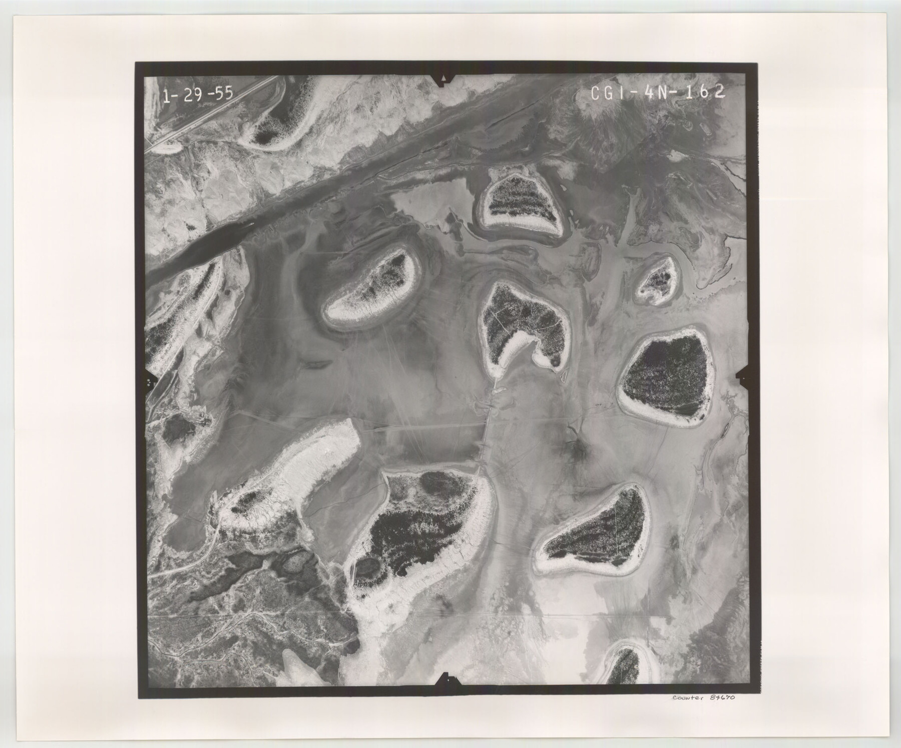
Flight Mission No. CGI-4N, Frame 162, Cameron County
CGI-4N-162
-
Map/Doc
84670
-
Collection
General Map Collection
-
Object Dates
1955/1/29 (Creation Date)
-
People and Organizations
U. S. Department of Agriculture (Publisher)
-
Counties
Cameron
-
Subjects
Aerial Photograph
-
Height x Width
18.7 x 22.5 inches
47.5 x 57.2 cm
-
Comments
Flown by Puckett Aerial Surveys, Inc. of Jackson, Mississippi.
Part of: General Map Collection
Gray County Rolled Sketch A

Print $20.00
- Digital $50.00
Gray County Rolled Sketch A
1888
Size 40.4 x 40.8 inches
Map/Doc 9008
Right of Way and Track Map International & Gt Northern Ry. operated by the International & Gt. Northern Ry. Co., San Antonio Division

Print $40.00
- Digital $50.00
Right of Way and Track Map International & Gt Northern Ry. operated by the International & Gt. Northern Ry. Co., San Antonio Division
1917
Size 25.9 x 57.5 inches
Map/Doc 64588
Comanche County Working Sketch 16

Print $20.00
- Digital $50.00
Comanche County Working Sketch 16
1969
Size 16.5 x 23.8 inches
Map/Doc 68150
Morris County Rolled Sketch 2A

Print $20.00
- Digital $50.00
Morris County Rolled Sketch 2A
Size 24.0 x 18.7 inches
Map/Doc 10287
Trinity County Sketch File 40

Print $20.00
- Digital $50.00
Trinity County Sketch File 40
1926
Size 16.5 x 21.8 inches
Map/Doc 12494
Flight Mission No. CUG-3P, Frame 83, Kleberg County

Print $20.00
- Digital $50.00
Flight Mission No. CUG-3P, Frame 83, Kleberg County
1956
Size 18.7 x 22.4 inches
Map/Doc 86258
Hydrographic Survey H-6396 of Outer Coast of Padre Island; Gulf of Mexico

Print $40.00
- Digital $50.00
Hydrographic Survey H-6396 of Outer Coast of Padre Island; Gulf of Mexico
1938
Size 54.4 x 33.5 inches
Map/Doc 2699
Stephens County Working Sketch 36

Print $20.00
- Digital $50.00
Stephens County Working Sketch 36
1980
Size 35.5 x 32.3 inches
Map/Doc 63979
Lamar County Working Sketch Graphic Index

Print $20.00
- Digital $50.00
Lamar County Working Sketch Graphic Index
1934
Size 47.9 x 37.5 inches
Map/Doc 76612
Freestone County Sketch File 15

Print $4.00
- Digital $50.00
Freestone County Sketch File 15
Size 6.3 x 8.2 inches
Map/Doc 23070
Freestone County

Print $40.00
- Digital $50.00
Freestone County
1988
Size 49.0 x 43.4 inches
Map/Doc 95502
Matagorda County

Print $20.00
- Digital $50.00
Matagorda County
1896
Size 32.7 x 30.5 inches
Map/Doc 5082
You may also like
[Sections 61-63, I. & G. N. Block 1 and sections 33 and 34, Block 194]
![91643, [Sections 61-63, I. & G. N. Block 1 and sections 33 and 34, Block 194], Twichell Survey Records](https://historictexasmaps.com/wmedia_w700/maps/91643-1.tif.jpg)
Print $20.00
- Digital $50.00
[Sections 61-63, I. & G. N. Block 1 and sections 33 and 34, Block 194]
Size 17.3 x 25.4 inches
Map/Doc 91643

Montgomery County Rolled Sketch 42

Print $20.00
- Digital $50.00
Montgomery County Rolled Sketch 42
1939
Size 14.1 x 20.1 inches
Map/Doc 6818
Pecos County Rolled Sketch 14

Print $40.00
- Digital $50.00
Pecos County Rolled Sketch 14
Size 39.5 x 82.3 inches
Map/Doc 75942
Val Verde County Sketch File Z3

Print $12.00
- Digital $50.00
Val Verde County Sketch File Z3
Size 8.8 x 7.8 inches
Map/Doc 39131
[Stone, Kyle and Kyle Block M6]
![90414, [Stone, Kyle and Kyle Block M6], Twichell Survey Records](https://historictexasmaps.com/wmedia_w700/maps/90414-1.tif.jpg)
Print $20.00
- Digital $50.00
[Stone, Kyle and Kyle Block M6]
1908
Size 18.6 x 25.5 inches
Map/Doc 90414
Flight Mission No. DCL-7C, Frame 67, Kenedy County

Print $20.00
- Digital $50.00
Flight Mission No. DCL-7C, Frame 67, Kenedy County
1943
Size 15.5 x 15.3 inches
Map/Doc 86053
Runnels County Sketch File 26

Print $20.00
Runnels County Sketch File 26
1949
Size 20.0 x 18.8 inches
Map/Doc 12260
Galveston County Working Sketch 12

Print $20.00
- Digital $50.00
Galveston County Working Sketch 12
1967
Size 14.8 x 22.4 inches
Map/Doc 69349
Nueces County Sketch File 49

Print $20.00
- Digital $50.00
Nueces County Sketch File 49
1956
Size 32.4 x 17.1 inches
Map/Doc 42193
Recharge zone of the Edwards Aquifer hydrologically associated with Barton Springs in the Austin Area, Texas

Print $20.00
- Digital $50.00
Recharge zone of the Edwards Aquifer hydrologically associated with Barton Springs in the Austin Area, Texas
1986
Size 41.5 x 29.3 inches
Map/Doc 60400
Sterling County Sketch File 26

Print $24.00
- Digital $50.00
Sterling County Sketch File 26
1989
Size 14.2 x 8.8 inches
Map/Doc 37194