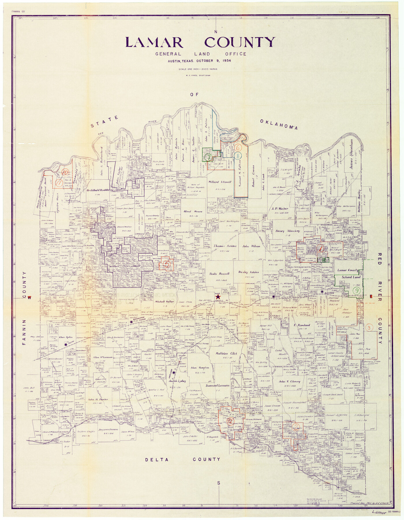
Lamar County Working Sketch Graphic Index
-
Map/Doc
76612
-
Collection
General Map Collection
-
Object Dates
10/9/1934 (Creation Date)
-
People and Organizations
W.S. Vines (Draftsman)
A. Clark (Tracer)
-
Counties
Lamar
-
Subjects
County Surveying Working Sketch
-
Height x Width
47.9 x 37.5 inches
121.7 x 95.3 cm
-
Scale
1" = 2000 varas
Part of: General Map Collection
Limestone County Working Sketch 8

Print $20.00
- Digital $50.00
Limestone County Working Sketch 8
1922
Size 30.6 x 18.4 inches
Map/Doc 70558
Rusk County Sketch File 32

Print $20.00
Rusk County Sketch File 32
1949
Size 33.5 x 28.4 inches
Map/Doc 10596
Flight Mission No. CGI-2N, Frame 155, Cameron County

Print $20.00
- Digital $50.00
Flight Mission No. CGI-2N, Frame 155, Cameron County
1954
Size 18.5 x 22.1 inches
Map/Doc 84537
Harris County Working Sketch 33

Print $20.00
- Digital $50.00
Harris County Working Sketch 33
1937
Size 21.4 x 20.6 inches
Map/Doc 65925
Hispaniae Novae Sivae Magnae Recens et Vera Descriptio 1579

Print $20.00
- Digital $50.00
Hispaniae Novae Sivae Magnae Recens et Vera Descriptio 1579
1581
Size 17.9 x 23.0 inches
Map/Doc 94036
Township No. 1 South Range No. 21 West of the Indian Meridian

Print $20.00
- Digital $50.00
Township No. 1 South Range No. 21 West of the Indian Meridian
1875
Size 19.2 x 24.5 inches
Map/Doc 75178
[Sketch for Mineral Application 26501 - Sabine River, T. A. Oldhausen]
![2840, [Sketch for Mineral Application 26501 - Sabine River, T. A. Oldhausen], General Map Collection](https://historictexasmaps.com/wmedia_w700/maps/2840.tif.jpg)
Print $20.00
- Digital $50.00
[Sketch for Mineral Application 26501 - Sabine River, T. A. Oldhausen]
1931
Size 24.3 x 35.5 inches
Map/Doc 2840
Crockett County Working Sketch 12

Print $20.00
- Digital $50.00
Crockett County Working Sketch 12
1915
Size 19.3 x 15.4 inches
Map/Doc 68345
Concho County Working Sketch 12

Print $20.00
- Digital $50.00
Concho County Working Sketch 12
1951
Size 23.0 x 27.2 inches
Map/Doc 68194
Padre Island National Seashore

Print $4.00
- Digital $50.00
Padre Island National Seashore
Size 16.2 x 22.1 inches
Map/Doc 60530
Austin County Working Sketch 3

Print $20.00
- Digital $50.00
Austin County Working Sketch 3
1950
Size 33.3 x 40.1 inches
Map/Doc 67244
Hays County Sketch File 2

Print $4.00
- Digital $50.00
Hays County Sketch File 2
1846
Size 6.3 x 8.1 inches
Map/Doc 26200
You may also like
Fisher County Working Sketch 9

Print $20.00
- Digital $50.00
Fisher County Working Sketch 9
1947
Size 18.1 x 17.9 inches
Map/Doc 69143
Flight Mission No. DQN-2K, Frame 90, Calhoun County

Print $20.00
- Digital $50.00
Flight Mission No. DQN-2K, Frame 90, Calhoun County
1953
Size 18.4 x 22.3 inches
Map/Doc 84280
Johnson's Military Map of the United States showing the Forts, Military Posts & all the Military Divisions with enlarged plans of southern harbors

Print $20.00
- Digital $50.00
Johnson's Military Map of the United States showing the Forts, Military Posts & all the Military Divisions with enlarged plans of southern harbors
1861
Map/Doc 93947
Dimmit County Rolled Sketch 15

Print $20.00
- Digital $50.00
Dimmit County Rolled Sketch 15
1925
Size 32.8 x 23.4 inches
Map/Doc 5723
Coleman County Rolled Sketch 2

Print $20.00
- Digital $50.00
Coleman County Rolled Sketch 2
Size 18.3 x 24.9 inches
Map/Doc 5528
Wichita County Boundary File 5

Print $20.00
- Digital $50.00
Wichita County Boundary File 5
Size 11.0 x 38.5 inches
Map/Doc 59915
K&E Both's Patent Section Liner and Scale Divider #1160

K&E Both's Patent Section Liner and Scale Divider #1160
Size 2.4 x 15.5 inches
Map/Doc 97304
Hoffman & Walker's Pictorial, Historical Map of Texas

Hoffman & Walker's Pictorial, Historical Map of Texas
1960
Size 44.0 x 45.5 inches
Map/Doc 2122
Map of Clay County

Print $20.00
- Digital $50.00
Map of Clay County
1874
Size 30.3 x 20.1 inches
Map/Doc 3403
Castro County Sketch File 1

Print $6.00
- Digital $50.00
Castro County Sketch File 1
1890
Size 8.8 x 7.8 inches
Map/Doc 17451
Nueces County NRC Article 33.136 Sketch 23

Print $42.00
Nueces County NRC Article 33.136 Sketch 23
2023
Map/Doc 97181
Fort Bend County Working Sketch 12

Print $40.00
- Digital $50.00
Fort Bend County Working Sketch 12
1940
Size 29.9 x 73.2 inches
Map/Doc 69219