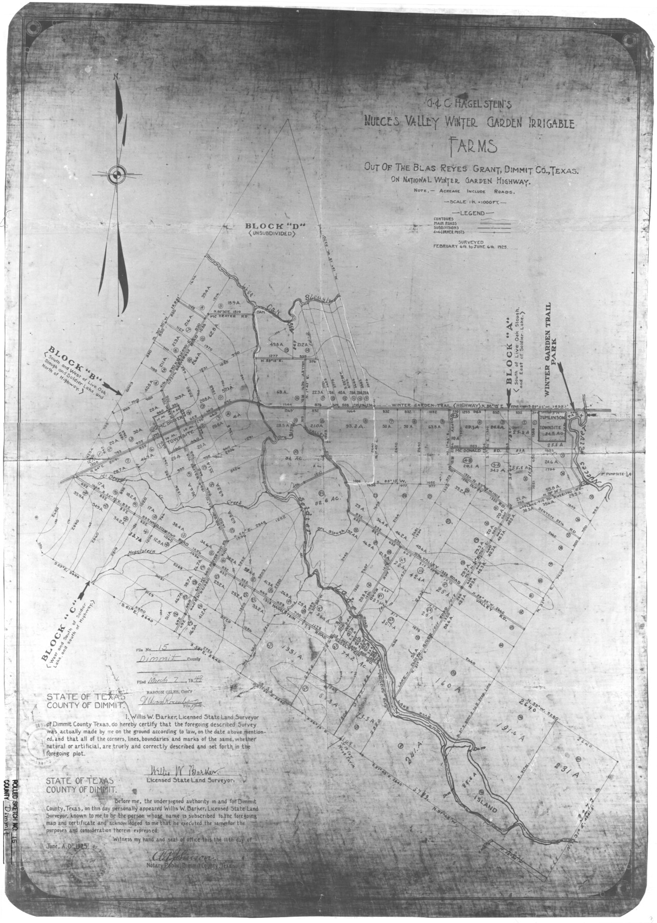
Dimmit County Rolled Sketch 15
G. & C. Hagelstein's Nueces Valley Winter Garden Irrigable Farms out of the Blas Reyes grant, Dimmit Co., Texas on National Winter Garden Highway
-
Map/Doc
5723
-
Collection
General Map Collection
-
Object Dates
1925/6/6 (Creation Date)
1949/3/7 (File Date)
-
People and Organizations
Willis W. Barker (Surveyor/Engineer)
-
Counties
Dimmit
-
Subjects
Surveying Rolled Sketch
-
Height x Width
32.8 x 23.4 inches
83.3 x 59.4 cm
-
Medium
photostat
-
Scale
1" = 1000 feet
Part of: General Map Collection
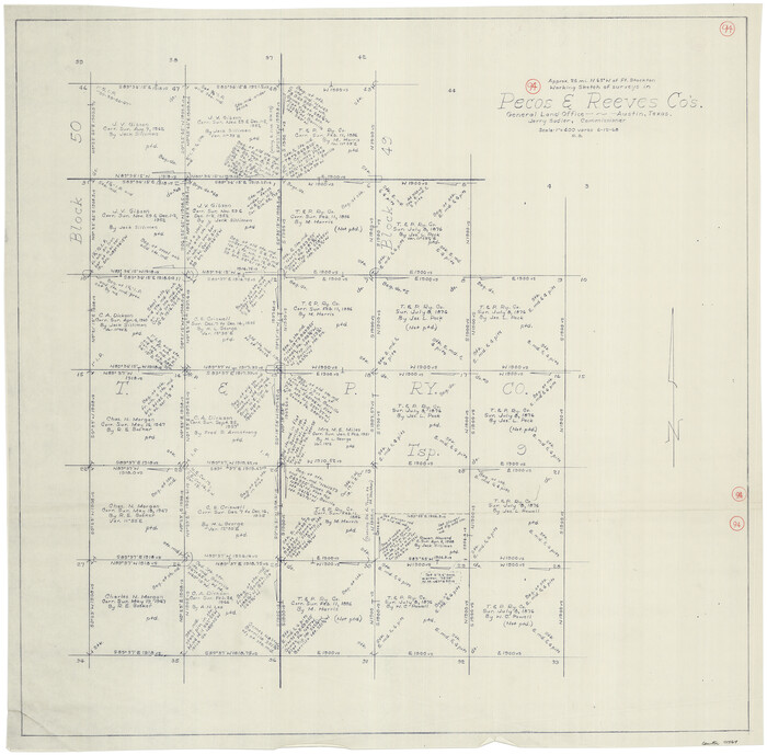
Pecos County Working Sketch 94
Print $20.00
- Digital $50.00
Pecos County Working Sketch 94
1968
Size 37.8 x 38.7 inches
Map/Doc 71567
Lynn County Rolled Sketch 13

Print $20.00
- Digital $50.00
Lynn County Rolled Sketch 13
Size 36.2 x 24.7 inches
Map/Doc 6649
Nueces County Rolled Sketch 61

Print $20.00
- Digital $50.00
Nueces County Rolled Sketch 61
1977
Size 32.2 x 39.3 inches
Map/Doc 6907
Matagorda County Rolled Sketch 25

Print $115.00
- Digital $50.00
Matagorda County Rolled Sketch 25
Size 9.7 x 15.0 inches
Map/Doc 46624
Val Verde County Sketch File XXX2

Print $20.00
- Digital $50.00
Val Verde County Sketch File XXX2
Size 18.6 x 17.9 inches
Map/Doc 12548
Van Zandt County Rolled Sketch 5

Print $20.00
- Digital $50.00
Van Zandt County Rolled Sketch 5
1946
Size 27.1 x 28.1 inches
Map/Doc 8146
Connected Map of Austin's Colony

Print $20.00
- Digital $50.00
Connected Map of Austin's Colony
1892
Size 47.5 x 43.0 inches
Map/Doc 76074
Harris County Working Sketch 101

Print $20.00
- Digital $50.00
Harris County Working Sketch 101
1980
Size 32.6 x 36.2 inches
Map/Doc 65993
Sutton County Sketch File 60

Print $20.00
- Digital $50.00
Sutton County Sketch File 60
Size 34.6 x 43.9 inches
Map/Doc 10378
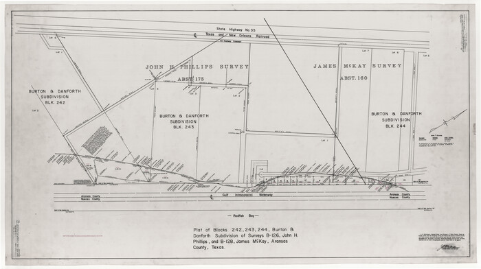
Aransas County Rolled Sketch 22
Print $40.00
- Digital $50.00
Aransas County Rolled Sketch 22
1980
Size 40.1 x 71.7 inches
Map/Doc 8416
Kleberg County Rolled Sketch 10-5

Print $20.00
- Digital $50.00
Kleberg County Rolled Sketch 10-5
1951
Size 37.6 x 35.6 inches
Map/Doc 9394
Medina County Rolled Sketch 9

Print $20.00
- Digital $50.00
Medina County Rolled Sketch 9
Size 18.8 x 31.0 inches
Map/Doc 6743
You may also like
Oldham County Sketch File 11

Print $26.00
- Digital $50.00
Oldham County Sketch File 11
Size 13.0 x 8.5 inches
Map/Doc 33247
America sive novvs orbis respectv evropaeorvm inferior globi terrestris pars 1596

Print $20.00
- Digital $50.00
America sive novvs orbis respectv evropaeorvm inferior globi terrestris pars 1596
1596
Size 14.7 x 18.1 inches
Map/Doc 93809
Map of Shackelford County

Print $20.00
- Digital $50.00
Map of Shackelford County
1878
Size 25.0 x 20.2 inches
Map/Doc 4025
Map of the Scripture Addition to the City of Denton

Print $20.00
- Digital $50.00
Map of the Scripture Addition to the City of Denton
Size 31.5 x 27.8 inches
Map/Doc 90589
East Part of Jeff Davis Co.

Print $20.00
- Digital $50.00
East Part of Jeff Davis Co.
1977
Size 40.6 x 30.9 inches
Map/Doc 77327
[Blocks M-23, M-17, M-18, H, G, and vicinity]
![91141, [Blocks M-23, M-17, M-18, H, G, and vicinity], Twichell Survey Records](https://historictexasmaps.com/wmedia_w700/maps/91141-1.tif.jpg)
Print $20.00
- Digital $50.00
[Blocks M-23, M-17, M-18, H, G, and vicinity]
1882
Size 12.9 x 12.4 inches
Map/Doc 91141
Brewster County Sketch File 20

Print $40.00
- Digital $50.00
Brewster County Sketch File 20
1946
Size 19.1 x 15.2 inches
Map/Doc 10979
Leon County Sketch File 37

Print $90.00
- Digital $50.00
Leon County Sketch File 37
1965
Size 11.2 x 8.8 inches
Map/Doc 29853
Travis County Working Sketch 26

Print $20.00
- Digital $50.00
Travis County Working Sketch 26
1951
Size 34.8 x 25.1 inches
Map/Doc 69410
Map of Rockport Texas, Aransas County

Print $20.00
- Digital $50.00
Map of Rockport Texas, Aransas County
1888
Size 29.0 x 20.5 inches
Map/Doc 380
Blanco County Boundary File 10

Print $26.00
- Digital $50.00
Blanco County Boundary File 10
Size 8.9 x 7.6 inches
Map/Doc 50576
Tarrant County Working Sketch 2

Print $20.00
- Digital $50.00
Tarrant County Working Sketch 2
1940
Size 21.3 x 19.5 inches
Map/Doc 62419