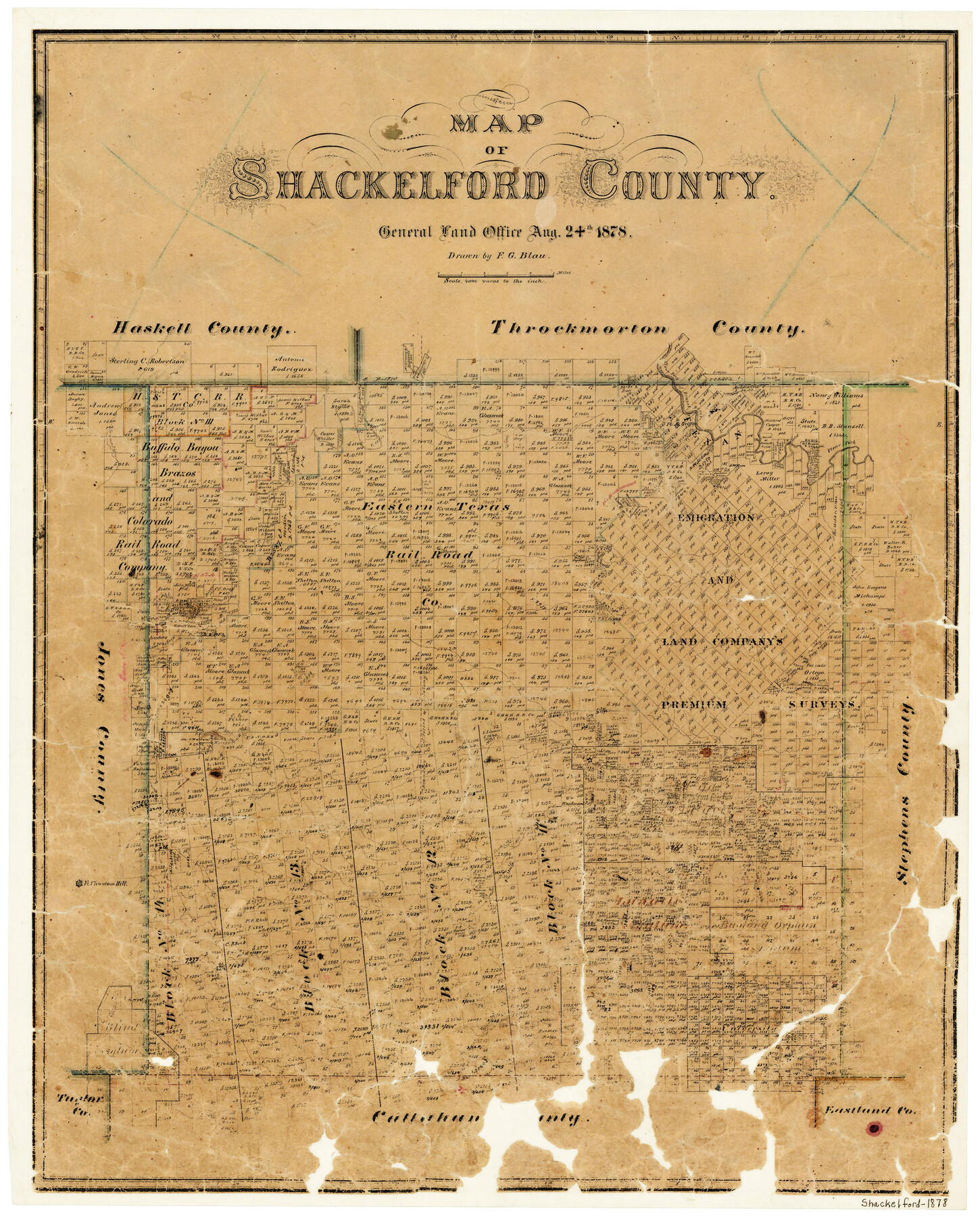
Map of Shackelford County
-
Map/Doc
4025
-
Collection
General Map Collection
-
Object Dates
8/24/1878 (Creation Date)
-
People and Organizations
Texas General Land Office (Publisher)
F.G. Blau (Draftsman)
-
Counties
Shackelford
-
Subjects
County
-
Height x Width
25.0 x 20.2 inches
63.5 x 51.3 cm
-
Features
Indian Creek
West Fork of Hubbard's Creek
Fort Griffin and Phantom Hill Road
Asylum Creek
Dead Man's Creek
West Fork of Howard's Creek
Albany
Williams Creek
West Caro Creek
Deep Creek
Clear Fork of Brazos River
South Fork of Mill Creek
Fort Phantom Hill
Phantom Hill Road
Fort Griffin Road
Mill Creek
Foyle's Creek
California Creek
Fort Griffin
Limpid Creek
Part of: General Map Collection
Presidio County Rolled Sketch 59

Print $20.00
- Digital $50.00
Presidio County Rolled Sketch 59
Size 27.6 x 18.2 inches
Map/Doc 7352
Edwards County Sketch File 29

Print $40.00
- Digital $50.00
Edwards County Sketch File 29
Size 19.4 x 15.9 inches
Map/Doc 11432
[Galveston, Harrisburg & San Antonio Railroad from Cuero to Stockdale]
![64200, [Galveston, Harrisburg & San Antonio Railroad from Cuero to Stockdale], General Map Collection](https://historictexasmaps.com/wmedia_w700/maps/64200.tif.jpg)
Print $20.00
- Digital $50.00
[Galveston, Harrisburg & San Antonio Railroad from Cuero to Stockdale]
1907
Size 14.0 x 34.1 inches
Map/Doc 64200
El Paso County Rolled Sketch 46A

Print $20.00
- Digital $50.00
El Paso County Rolled Sketch 46A
1937
Size 35.1 x 30.2 inches
Map/Doc 5833

Milam County Working Sketch 17

Print $40.00
- Digital $50.00
Milam County Working Sketch 17
1972
Size 54.7 x 32.2 inches
Map/Doc 89031
Henderson County Working Sketch 9

Print $20.00
- Digital $50.00
Henderson County Working Sketch 9
1921
Size 30.9 x 16.7 inches
Map/Doc 66142
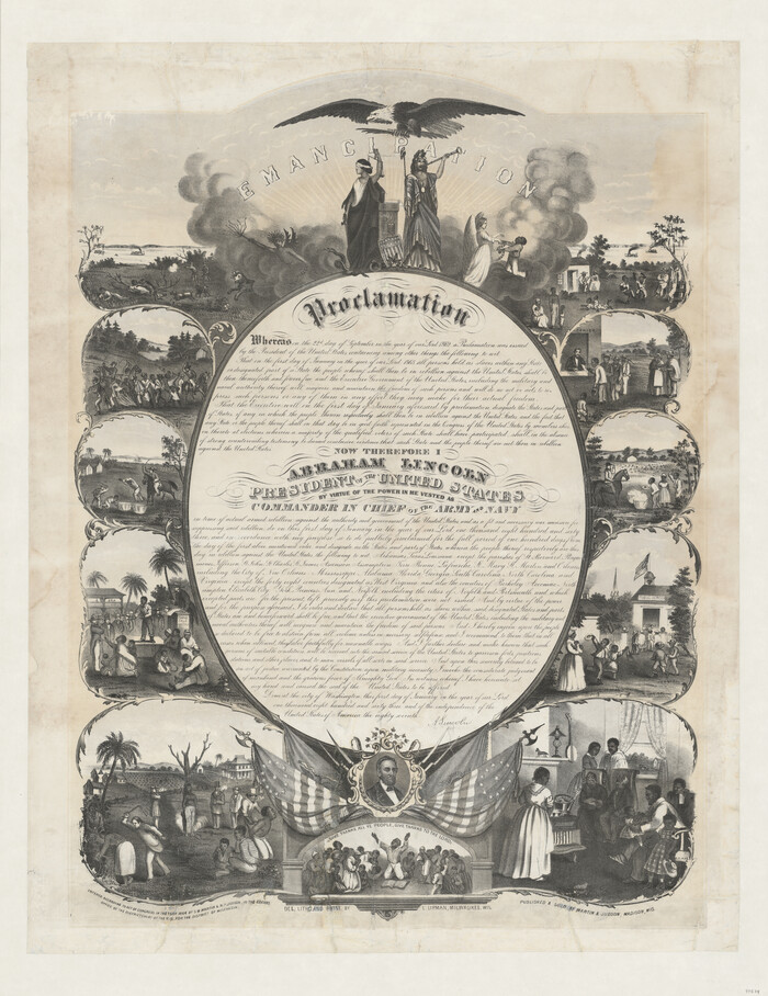
Emancipation Proclamation
Print $20.00
- Digital $50.00
Emancipation Proclamation
1864
Size 29.5 x 22.7 inches
Map/Doc 97534
[Fort Worth & Rio Grande Ry.] Map, Tracings of Located Line, Dublin to Comanche
![64353, [Fort Worth & Rio Grande Ry.] Map, Tracings of Located Line, Dublin to Comanche, General Map Collection](https://historictexasmaps.com/wmedia_w700/maps/64353.tif.jpg)
Print $20.00
- Digital $50.00
[Fort Worth & Rio Grande Ry.] Map, Tracings of Located Line, Dublin to Comanche
Size 15.3 x 41.6 inches
Map/Doc 64353
Colorado County Working Sketch 18

Print $20.00
- Digital $50.00
Colorado County Working Sketch 18
1957
Size 31.2 x 37.3 inches
Map/Doc 68118
Crockett County Working Sketch 16

Print $20.00
- Digital $50.00
Crockett County Working Sketch 16
1917
Size 24.0 x 29.0 inches
Map/Doc 68349
Aransas County NRC Article 33.136 Sketch 7

Print $46.00
- Digital $50.00
Aransas County NRC Article 33.136 Sketch 7
2000
Size 11.0 x 8.6 inches
Map/Doc 13563
You may also like
Nueces County Rolled Sketch 62

Print $20.00
- Digital $50.00
Nueces County Rolled Sketch 62
1977
Size 25.0 x 33.3 inches
Map/Doc 6908
Flight Mission No. DCL-6C, Frame 66, Kenedy County

Print $20.00
- Digital $50.00
Flight Mission No. DCL-6C, Frame 66, Kenedy County
1943
Size 18.7 x 22.4 inches
Map/Doc 85908
Map of Hardin County

Print $20.00
- Digital $50.00
Map of Hardin County
1902
Size 40.8 x 43.9 inches
Map/Doc 4971
Hill County Sketch File 3

Print $2.00
- Digital $50.00
Hill County Sketch File 3
Size 8.3 x 10.4 inches
Map/Doc 26463
Vehlein and Company Empresario Colony. December 21, 1826

Print $20.00
Vehlein and Company Empresario Colony. December 21, 1826
2020
Size 20.8 x 21.7 inches
Map/Doc 96007
Wheeler County Working Sketch Graphic Index

Print $20.00
- Digital $50.00
Wheeler County Working Sketch Graphic Index
1899
Size 41.4 x 36.8 inches
Map/Doc 76738
Gaines County Working Sketch 7

Print $20.00
- Digital $50.00
Gaines County Working Sketch 7
1940
Size 16.5 x 38.5 inches
Map/Doc 69307
Goliad County Sketch File 24

Print $16.00
- Digital $50.00
Goliad County Sketch File 24
1856
Size 12.9 x 8.2 inches
Map/Doc 24297
Jefferson County Working Sketch 43

Print $20.00
- Digital $50.00
Jefferson County Working Sketch 43
1960
Size 42.7 x 31.1 inches
Map/Doc 73591
Menard County Rolled Sketch 2A

Print $20.00
- Digital $50.00
Menard County Rolled Sketch 2A
1905
Size 23.3 x 18.5 inches
Map/Doc 6753
Glasscock County Working Sketch 8

Print $20.00
- Digital $50.00
Glasscock County Working Sketch 8
Size 42.7 x 10.3 inches
Map/Doc 62189
Wilson County Working Sketch 3

Print $20.00
- Digital $50.00
Wilson County Working Sketch 3
1952
Size 33.6 x 33.2 inches
Map/Doc 72583