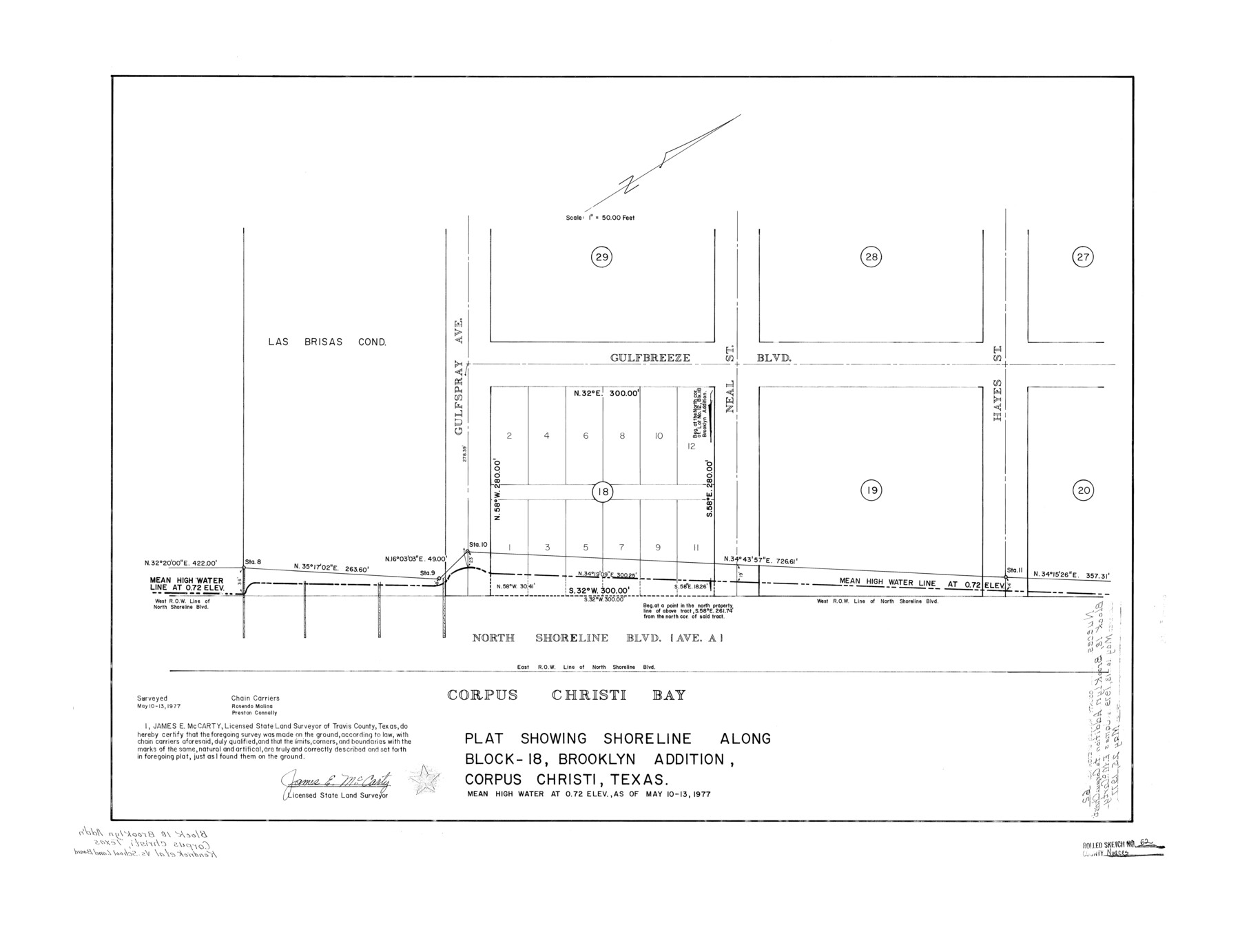
Nueces County Rolled Sketch 62
Plat showing shoreline along Block-18, Brooklyn Addition, Corpus Christi, Texas
-
Map/Doc
6908
-
Collection
General Map Collection
-
Object Dates
1977/5/13 (Creation Date)
1977/5/25 (File Date)
-
People and Organizations
James E. McCarty (Surveyor/Engineer)
Rosendo V. Molina (Chainman/Field Personnel)
Preston R. Connally (Chainman/Field Personnel)
-
Counties
Nueces
-
Subjects
Surveying Rolled Sketch
-
Height x Width
25.0 x 33.3 inches
63.5 x 84.6 cm
-
Medium
mylar, print
-
Scale
1" = 50 feet
Part of: General Map Collection

Jeff Davis County Sketch File 25

Print $32.00
- Digital $50.00
Jeff Davis County Sketch File 25
1886
Size 11.3 x 8.5 inches
Map/Doc 27992
Northern Part of Laguna Madre

Print $20.00
- Digital $50.00
Northern Part of Laguna Madre
1988
Size 45.1 x 36.4 inches
Map/Doc 73531
Freestone County Working Sketch 5

Print $40.00
- Digital $50.00
Freestone County Working Sketch 5
Size 37.8 x 67.4 inches
Map/Doc 69247
Culberson County Working Sketch 1

Print $20.00
- Digital $50.00
Culberson County Working Sketch 1
Size 21.6 x 42.7 inches
Map/Doc 68453
Webb County Working Sketch 65

Print $40.00
- Digital $50.00
Webb County Working Sketch 65
1964
Size 49.0 x 59.5 inches
Map/Doc 72431
Crosby County Rolled Sketch 2

Print $20.00
- Digital $50.00
Crosby County Rolled Sketch 2
1980
Size 24.7 x 18.7 inches
Map/Doc 5642
Zavala County Working Sketch 29

Print $20.00
- Digital $50.00
Zavala County Working Sketch 29
1994
Size 33.1 x 42.9 inches
Map/Doc 62104
Presidio County Rolled Sketch 83B

Print $20.00
- Digital $50.00
Presidio County Rolled Sketch 83B
Size 16.6 x 23.0 inches
Map/Doc 2061
Comal County Sketch File 20

Print $6.00
- Digital $50.00
Comal County Sketch File 20
1857
Size 12.4 x 8.1 inches
Map/Doc 19039
Culberson County Sketch File 23

Print $10.00
- Digital $50.00
Culberson County Sketch File 23
1938
Size 14.2 x 8.6 inches
Map/Doc 20238
Ector County Sketch File 13

Print $16.00
- Digital $50.00
Ector County Sketch File 13
1988
Size 11.5 x 9.0 inches
Map/Doc 21651
You may also like
Panola County Working Sketch 35

Print $40.00
- Digital $50.00
Panola County Working Sketch 35
1983
Map/Doc 71444
Smith County Working Sketch 13

Print $20.00
- Digital $50.00
Smith County Working Sketch 13
1962
Size 36.8 x 27.4 inches
Map/Doc 63898
Palo Pinto County

Print $20.00
- Digital $50.00
Palo Pinto County
1941
Size 44.9 x 35.9 inches
Map/Doc 77389
Galveston - The Playground of the Nation

Galveston - The Playground of the Nation
1913
Size 6.1 x 8.3 inches
Map/Doc 97060
Map of Travis Co.

Print $40.00
- Digital $50.00
Map of Travis Co.
1850
Size 37.2 x 50.8 inches
Map/Doc 78387

Midland County Rolled Sketch 2

Print $20.00
- Digital $50.00
Midland County Rolled Sketch 2
1949
Size 39.3 x 36.5 inches
Map/Doc 9513
Presidio County Rolled Sketch 131A

Print $3.00
- Digital $50.00
Presidio County Rolled Sketch 131A
Size 15.8 x 9.3 inches
Map/Doc 10708
Flight Mission No. BRA-7M, Frame 138, Jefferson County

Print $20.00
- Digital $50.00
Flight Mission No. BRA-7M, Frame 138, Jefferson County
1953
Size 18.6 x 22.4 inches
Map/Doc 85532
[Redfish Bay, Aransas Pass, and part of Mustang Island]
![83009, [Redfish Bay, Aransas Pass, and part of Mustang Island], General Map Collection](https://historictexasmaps.com/wmedia_w700/maps/83009.tif.jpg)
Print $40.00
- Digital $50.00
[Redfish Bay, Aransas Pass, and part of Mustang Island]
1930
Size 51.0 x 46.5 inches
Map/Doc 83009
Swisher County Sketch File 5

Print $8.00
- Digital $50.00
Swisher County Sketch File 5
1876
Size 14.3 x 8.8 inches
Map/Doc 37618
Flight Mission No. DAH-17M, Frame 18, Orange County

Print $20.00
- Digital $50.00
Flight Mission No. DAH-17M, Frame 18, Orange County
1953
Size 18.5 x 22.6 inches
Map/Doc 86881