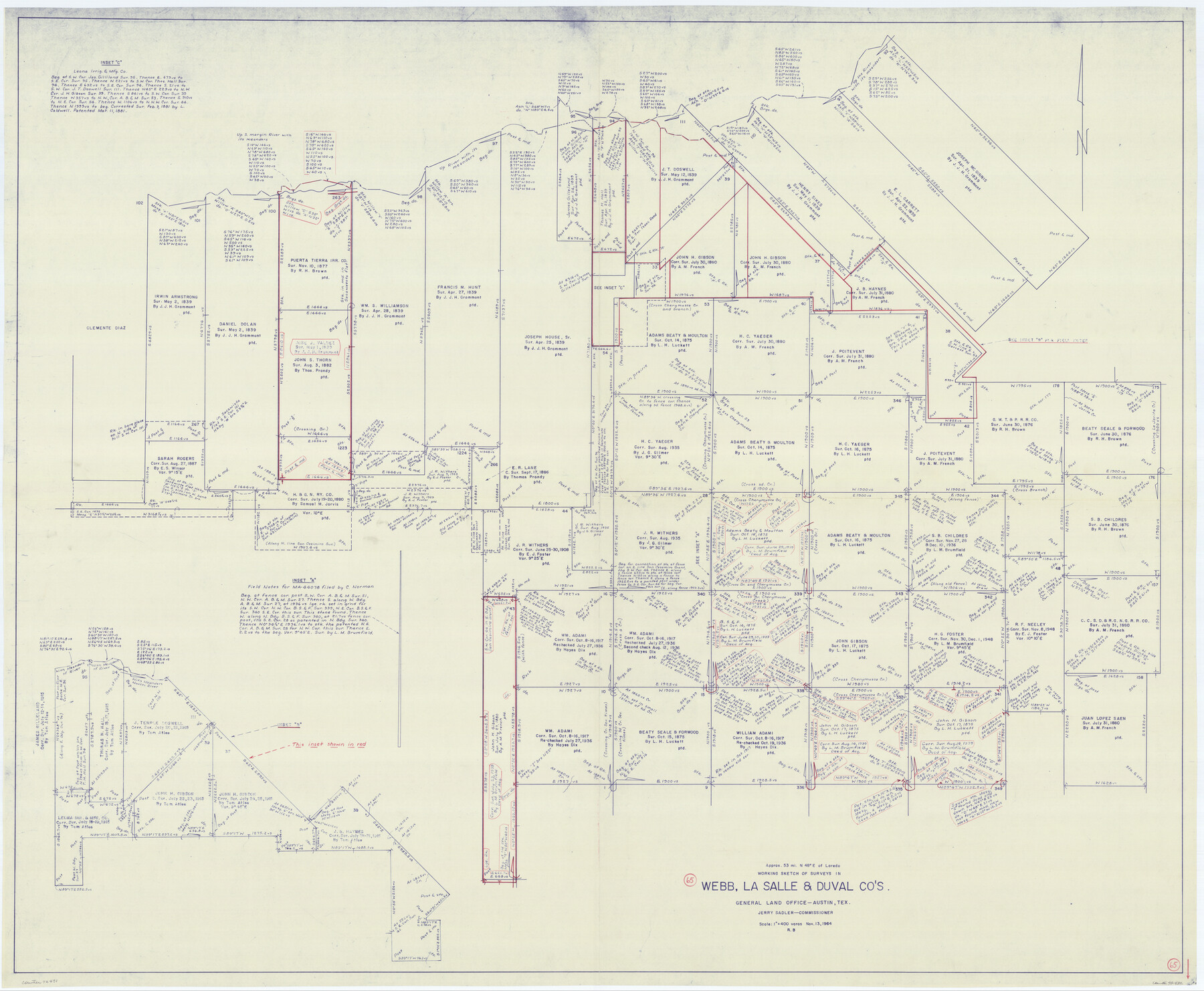
Webb County Working Sketch 65
-
Map/Doc
72431
-
Collection
General Map Collection
-
Object Dates
11/13/1964 (Creation Date)
-
People and Organizations
Roy Buckholts (Draftsman)
-
Counties
Webb La Salle Duval
-
Subjects
Surveying Working Sketch
-
Height x Width
49.0 x 59.5 inches
124.5 x 151.1 cm
-
Scale
1" = 400 varas
Part of: General Map Collection
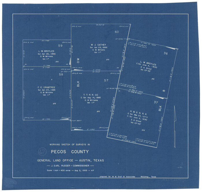
Pecos County Working Sketch 67
Print $20.00
- Digital $50.00
Pecos County Working Sketch 67
1955
Size 17.7 x 18.7 inches
Map/Doc 71539
Crockett County Rolled Sketch 75

Print $20.00
- Digital $50.00
Crockett County Rolled Sketch 75
1949
Size 17.6 x 21.1 inches
Map/Doc 5616
Comanche County Working Sketch 10

Print $20.00
- Digital $50.00
Comanche County Working Sketch 10
1954
Size 21.4 x 18.0 inches
Map/Doc 68144
Montgomery County Working Sketch 75

Print $40.00
- Digital $50.00
Montgomery County Working Sketch 75
1986
Size 30.9 x 82.8 inches
Map/Doc 71182
Map of Eastland County, the portion on the waters of Colorado River, Travis - the balance, Milam Land District

Print $20.00
- Digital $50.00
Map of Eastland County, the portion on the waters of Colorado River, Travis - the balance, Milam Land District
1860
Size 23.8 x 21.5 inches
Map/Doc 3501
[Map of Polk County]
![4613, [Map of Polk County], General Map Collection](https://historictexasmaps.com/wmedia_w700/maps/4613-1.tif.jpg)
Print $20.00
- Digital $50.00
[Map of Polk County]
1855
Size 21.2 x 31.0 inches
Map/Doc 4613
Fannin County Sketch File 13

Print $4.00
- Digital $50.00
Fannin County Sketch File 13
Size 8.1 x 7.9 inches
Map/Doc 22462
Colorado County Sketch File 18

Print $40.00
- Digital $50.00
Colorado County Sketch File 18
1897
Size 12.5 x 15.8 inches
Map/Doc 18950

Flight Mission No. CLL-1N, Frame 19, Willacy County

Print $20.00
- Digital $50.00
Flight Mission No. CLL-1N, Frame 19, Willacy County
1954
Size 18.3 x 22.1 inches
Map/Doc 87006
Tyler County Sketch File 17b

Print $4.00
- Digital $50.00
Tyler County Sketch File 17b
Size 12.0 x 8.0 inches
Map/Doc 38666
Somervell County Sketch File 1

Print $4.00
- Digital $50.00
Somervell County Sketch File 1
1859
Size 12.8 x 8.1 inches
Map/Doc 36795
You may also like

Events of the Texas Revolution

Events of the Texas Revolution
2023
Size 8.5 x 11.0 inches
Map/Doc 97188
McCulloch County Sketch File 3

Print $12.00
- Digital $50.00
McCulloch County Sketch File 3
1893
Size 11.1 x 8.5 inches
Map/Doc 31169
Moore County Working Sketch 6

Print $20.00
- Digital $50.00
Moore County Working Sketch 6
1921
Size 16.0 x 14.5 inches
Map/Doc 71188
General Highway Map, Angelina County, Texas

Print $20.00
General Highway Map, Angelina County, Texas
1940
Size 18.5 x 24.9 inches
Map/Doc 79003
[Tom Green County]
![16901, [Tom Green County], General Map Collection](https://historictexasmaps.com/wmedia_w700/maps/16901.tif.jpg)
Print $20.00
- Digital $50.00
[Tom Green County]
1888
Size 33.2 x 34.4 inches
Map/Doc 16901
Map of Hays County, Texas

Print $20.00
- Digital $50.00
Map of Hays County, Texas
1880
Size 24.3 x 21.4 inches
Map/Doc 5029
Brazos Santiago, Texas

Print $20.00
- Digital $50.00
Brazos Santiago, Texas
1882
Size 9.0 x 16.9 inches
Map/Doc 97186
[Atchison, Topeka & Santa Fe from Paisano to south of Plata]
![64709, [Atchison, Topeka & Santa Fe from Paisano to south of Plata], General Map Collection](https://historictexasmaps.com/wmedia_w700/maps/64709.tif.jpg)
Print $40.00
- Digital $50.00
[Atchison, Topeka & Santa Fe from Paisano to south of Plata]
Size 32.3 x 120.8 inches
Map/Doc 64709
Flight Mission No. DCL-6C, Frame 118, Kenedy County

Print $20.00
- Digital $50.00
Flight Mission No. DCL-6C, Frame 118, Kenedy County
1943
Size 18.6 x 22.4 inches
Map/Doc 85948
McCulloch County Sketch File 12

Print $6.00
- Digital $50.00
McCulloch County Sketch File 12
1989
Size 14.2 x 8.6 inches
Map/Doc 31198
Flight Mission No. CRC-4R, Frame 98, Chambers County

Print $20.00
- Digital $50.00
Flight Mission No. CRC-4R, Frame 98, Chambers County
1956
Size 18.6 x 22.3 inches
Map/Doc 84895