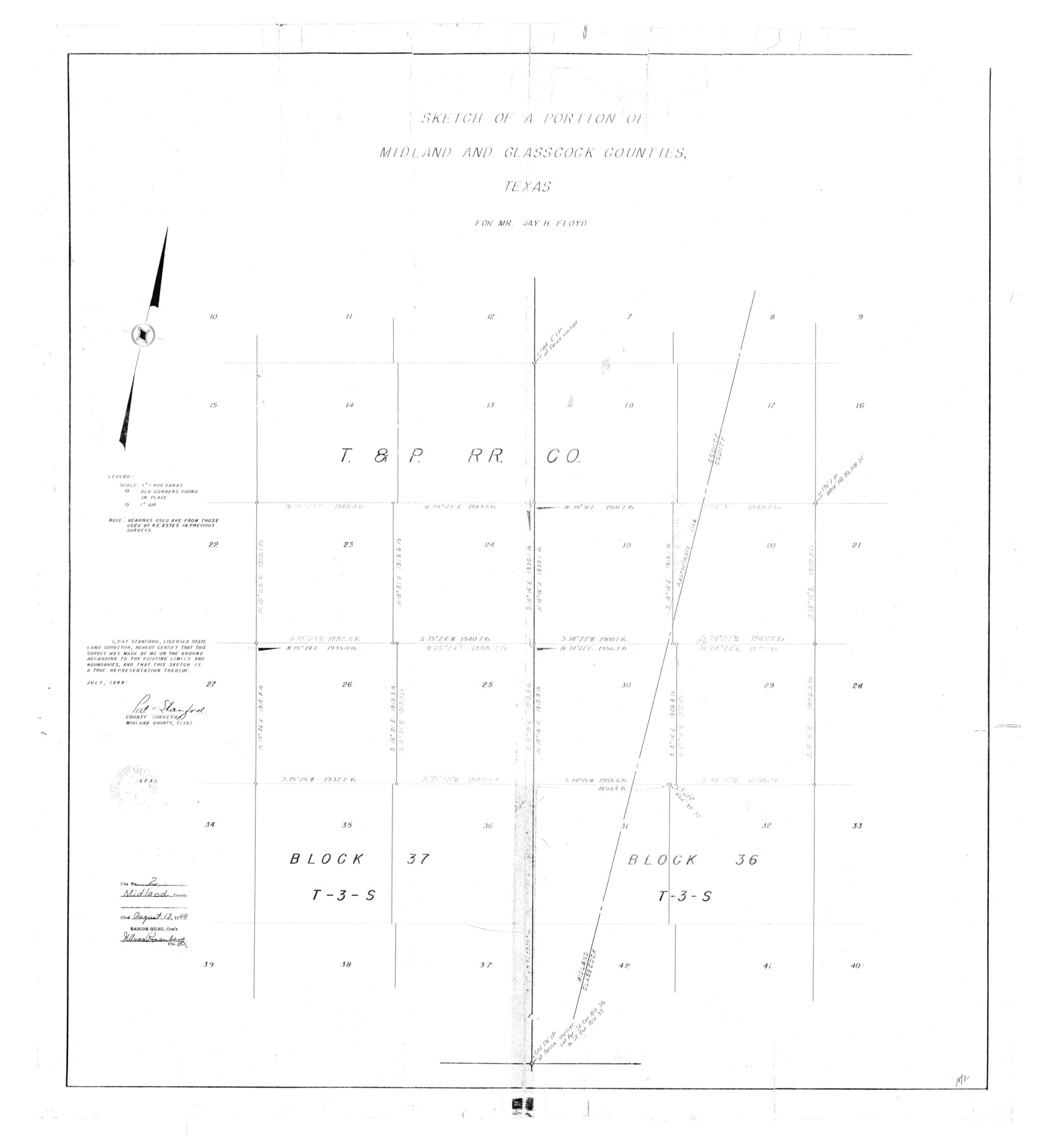
Midland County Rolled Sketch 2
Sketch of a portion of Midland and Glasscock Counties, Texas for Mr. Jay H. Ford
-
Map/Doc
9513
-
Collection
General Map Collection
-
Object Dates
1949 (Creation Date)
1949/8/13 (File Date)
-
People and Organizations
Pat Stanford (Surveyor/Engineer)
-
Counties
Midland Glasscock
-
Subjects
Surveying Rolled Sketch
-
Height x Width
39.3 x 36.5 inches
99.8 x 92.7 cm
-
Scale
1" = 400 varas
Part of: General Map Collection
Matagorda County Rolled Sketch 33

Print $40.00
- Digital $50.00
Matagorda County Rolled Sketch 33
1957
Size 43.5 x 63.0 inches
Map/Doc 9482
University Land in Hudspeth County showing Mineral Surveys in Blocks A, B, C, D, E, F, G, H, I, J, K, L, M, N

Print $40.00
- Digital $50.00
University Land in Hudspeth County showing Mineral Surveys in Blocks A, B, C, D, E, F, G, H, I, J, K, L, M, N
Size 39.7 x 48.4 inches
Map/Doc 2421
Map of the reconnaissance in Texas by Lieuts Blake & Meade of the Corps of Topl. Engs.

Print $20.00
- Digital $50.00
Map of the reconnaissance in Texas by Lieuts Blake & Meade of the Corps of Topl. Engs.
1846
Size 27.1 x 22.5 inches
Map/Doc 2003
Texas-Indian Territory Gainesville Quadrangle

Print $20.00
- Digital $50.00
Texas-Indian Territory Gainesville Quadrangle
1913
Size 20.4 x 16.9 inches
Map/Doc 75103
Crockett County Rolled Sketch 94

Print $40.00
- Digital $50.00
Crockett County Rolled Sketch 94
1979
Size 45.0 x 49.7 inches
Map/Doc 8738
[Surveys in Austin's Colony along Hickory Creek, Hog Creek, and the Yegua River]
![195, [Surveys in Austin's Colony along Hickory Creek, Hog Creek, and the Yegua River], General Map Collection](https://historictexasmaps.com/wmedia_w700/maps/195.tif.jpg)
Print $20.00
- Digital $50.00
[Surveys in Austin's Colony along Hickory Creek, Hog Creek, and the Yegua River]
1831
Size 19.4 x 23.9 inches
Map/Doc 195
Edwards County Working Sketch 39

Print $20.00
- Digital $50.00
Edwards County Working Sketch 39
1948
Size 28.7 x 32.3 inches
Map/Doc 68915
Midland County Boundary File 1

Print $40.00
- Digital $50.00
Midland County Boundary File 1
Size 7.0 x 6.6 inches
Map/Doc 57140
Railroad Track Map, H&TCRRCo., Falls County, Texas

Print $4.00
- Digital $50.00
Railroad Track Map, H&TCRRCo., Falls County, Texas
1918
Size 11.7 x 18.7 inches
Map/Doc 62845
Armstrong County Sketch File A-7

Print $40.00
- Digital $50.00
Armstrong County Sketch File A-7
Size 15.0 x 20.4 inches
Map/Doc 10848
Martin County Boundary File 2a

Print $6.00
- Digital $50.00
Martin County Boundary File 2a
Size 14.1 x 8.8 inches
Map/Doc 56776
Falls County Sketch File 21a

Print $54.00
- Digital $50.00
Falls County Sketch File 21a
1869
Size 13.0 x 8.2 inches
Map/Doc 22396
You may also like
McMullen County Working Sketch 37

Print $20.00
- Digital $50.00
McMullen County Working Sketch 37
1969
Size 37.4 x 38.4 inches
Map/Doc 70738
A General Map of North America drawn from the best surveys

Print $20.00
- Digital $50.00
A General Map of North America drawn from the best surveys
1795
Map/Doc 93944
Blanco County Working Sketch 13

Print $20.00
- Digital $50.00
Blanco County Working Sketch 13
1948
Size 42.6 x 33.6 inches
Map/Doc 67373
Sutton County Rolled Sketch 68

Print $20.00
- Digital $50.00
Sutton County Rolled Sketch 68
Size 31.0 x 37.4 inches
Map/Doc 9980
Flight Mission No. DIX-3P, Frame 172, Aransas County

Print $20.00
- Digital $50.00
Flight Mission No. DIX-3P, Frame 172, Aransas County
1956
Size 17.7 x 18.3 inches
Map/Doc 83778
EL&RR S2, HE&WT K3, Pt.L&SV K, C4 & C3

Print $20.00
- Digital $50.00
EL&RR S2, HE&WT K3, Pt.L&SV K, C4 & C3
Size 23.3 x 17.5 inches
Map/Doc 90416
Rusk County Sketch File 35

Print $6.00
Rusk County Sketch File 35
1950
Size 11.3 x 8.8 inches
Map/Doc 35573
Young County Rolled Sketch 5

Print $20.00
- Digital $50.00
Young County Rolled Sketch 5
Size 20.2 x 26.1 inches
Map/Doc 8293
Mason County Sketch File 22

Print $8.00
- Digital $50.00
Mason County Sketch File 22
1932
Size 11.1 x 8.9 inches
Map/Doc 30719
Hutchinson County Rolled Sketch 40

Print $20.00
- Digital $50.00
Hutchinson County Rolled Sketch 40
1981
Size 26.8 x 37.4 inches
Map/Doc 6303
Angelina River, Mud Creek, Sheet 3

Print $4.00
- Digital $50.00
Angelina River, Mud Creek, Sheet 3
1937
Size 18.7 x 26.6 inches
Map/Doc 65077
Hudspeth County Working Sketch 10

Print $20.00
- Digital $50.00
Hudspeth County Working Sketch 10
1941
Size 16.0 x 17.1 inches
Map/Doc 66291