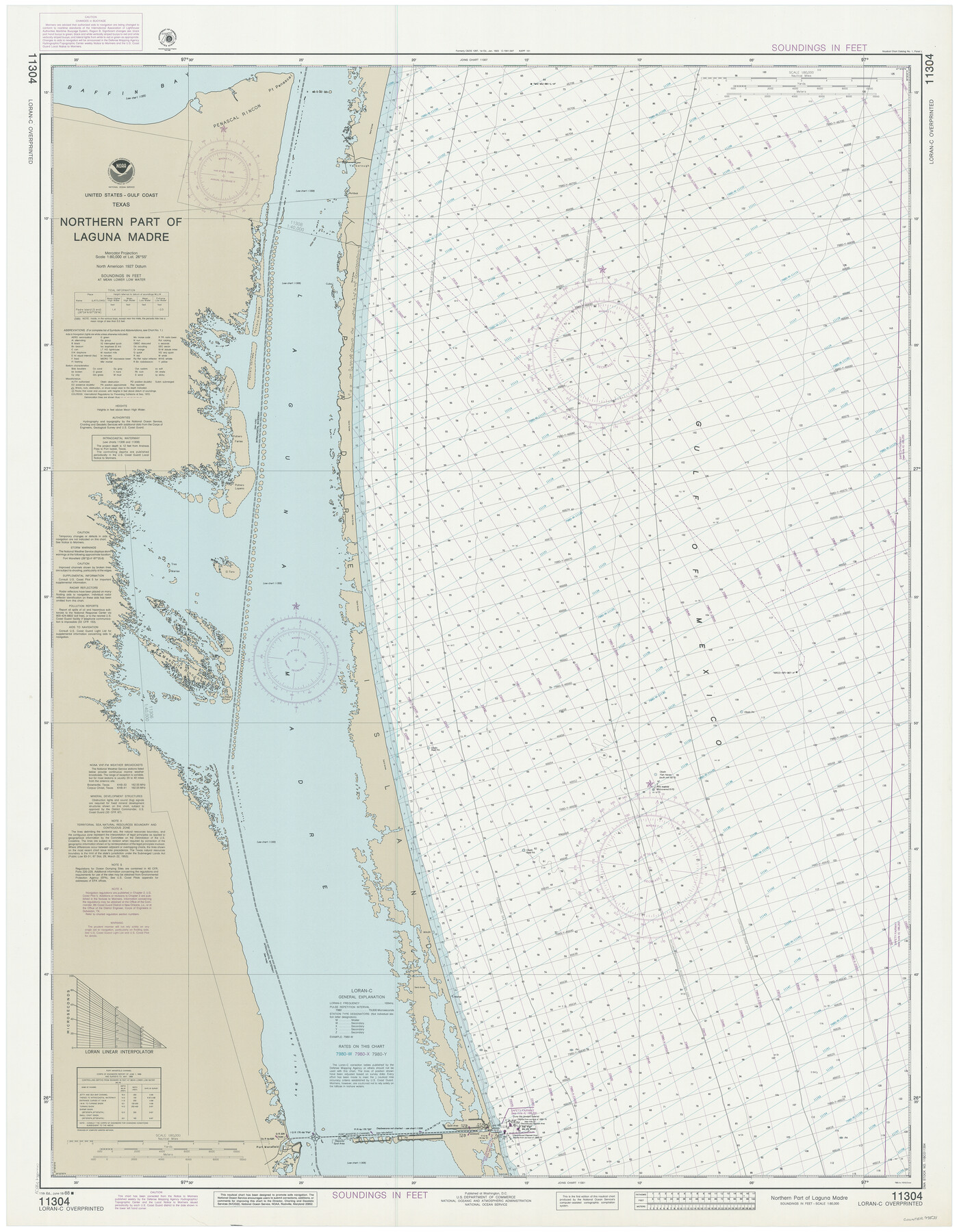
Northern Part of Laguna Madre
K-6-1287a
-
Map/Doc
73531
-
Collection
General Map Collection
-
Object Dates
6/18/1988 (Creation Date)
-
Counties
Kenedy Willacy
-
Subjects
Nautical Charts
-
Height x Width
45.1 x 36.4 inches
114.6 x 92.5 cm
Part of: General Map Collection
Reagan County Working Sketch 42

Print $20.00
- Digital $50.00
Reagan County Working Sketch 42
1973
Size 19.9 x 37.0 inches
Map/Doc 71884


Lynn County Working Sketch 4

Print $20.00
- Digital $50.00
Lynn County Working Sketch 4
1965
Size 33.5 x 33.8 inches
Map/Doc 70674
San Patricio County NRC Article 33.136 Sketch 1

Print $32.00
- Digital $50.00
San Patricio County NRC Article 33.136 Sketch 1
2001
Size 18.5 x 24.1 inches
Map/Doc 61623
Flight Mission No. BRE-1P, Frame 119, Nueces County

Print $20.00
- Digital $50.00
Flight Mission No. BRE-1P, Frame 119, Nueces County
1956
Size 18.7 x 22.7 inches
Map/Doc 86685
Refugio County Boundary File 3a

Print $28.00
- Digital $50.00
Refugio County Boundary File 3a
Size 14.1 x 8.8 inches
Map/Doc 58246
Flight Mission No. CRC-1R, Frame 156, Chambers County

Print $20.00
- Digital $50.00
Flight Mission No. CRC-1R, Frame 156, Chambers County
1956
Size 18.7 x 22.5 inches
Map/Doc 84718
Fractional Township No. 8 South Range No. 2 East of the Indian Meridian, Indian Territory

Print $20.00
- Digital $50.00
Fractional Township No. 8 South Range No. 2 East of the Indian Meridian, Indian Territory
1898
Size 19.3 x 24.3 inches
Map/Doc 75204
Sabine River, North Extension Merrill Lake Sheet

Print $20.00
- Digital $50.00
Sabine River, North Extension Merrill Lake Sheet
1933
Size 23.2 x 42.6 inches
Map/Doc 65140
Right of Way and Track Map, the Missouri, Kansas and Texas Ry. of Texas - Henrietta Division

Print $20.00
- Digital $50.00
Right of Way and Track Map, the Missouri, Kansas and Texas Ry. of Texas - Henrietta Division
1918
Size 11.8 x 26.8 inches
Map/Doc 64750
Wise County Sketch File 9

Print $5.00
- Digital $50.00
Wise County Sketch File 9
1854
Size 11.9 x 14.8 inches
Map/Doc 40539
You may also like
[Surveys in the vicinity of Coyote Lake, Bailey County]
![90196, [Surveys in the vicinity of Coyote Lake, Bailey County], Twichell Survey Records](https://historictexasmaps.com/wmedia_w700/maps/90196-1.tif.jpg)
Print $20.00
- Digital $50.00
[Surveys in the vicinity of Coyote Lake, Bailey County]
1913
Size 27.6 x 27.3 inches
Map/Doc 90196
Flight Mission No. DAG-21K, Frame 99, Matagorda County

Print $20.00
- Digital $50.00
Flight Mission No. DAG-21K, Frame 99, Matagorda County
1952
Size 17.5 x 16.3 inches
Map/Doc 86428
General Highway Map, Ellis County, Texas

Print $20.00
General Highway Map, Ellis County, Texas
1961
Size 18.2 x 24.6 inches
Map/Doc 79453
James Subdivision, NE/4 Section 1, Block E, G. C. & S. F. R.R. Co. Cert 3/360, Abstract 46

Print $20.00
- Digital $50.00
James Subdivision, NE/4 Section 1, Block E, G. C. & S. F. R.R. Co. Cert 3/360, Abstract 46
Size 17.8 x 19.4 inches
Map/Doc 92734
Map of Scurry County

Print $20.00
- Digital $50.00
Map of Scurry County
1899
Size 39.8 x 34.7 inches
Map/Doc 63029
Carta General de la República Mexicana formada por Antonio García y Cubas

Print $40.00
Carta General de la República Mexicana formada por Antonio García y Cubas
1863
Size 48.7 x 57.1 inches
Map/Doc 95307
Hardin County Sketch File 16

Print $8.00
- Digital $50.00
Hardin County Sketch File 16
Size 8.3 x 11.4 inches
Map/Doc 25125
Terrell County Rolled Sketch 36

Print $20.00
- Digital $50.00
Terrell County Rolled Sketch 36
1940
Size 17.4 x 33.8 inches
Map/Doc 9989
El Paso County Sketch File 35 (2)

Print $18.00
- Digital $50.00
El Paso County Sketch File 35 (2)
1886
Size 12.9 x 8.3 inches
Map/Doc 22170
Jefferson County Rolled Sketch 57

Print $20.00
- Digital $50.00
Jefferson County Rolled Sketch 57
1874
Size 25.9 x 18.6 inches
Map/Doc 6408
Map of Texas and part of New Mexico

Print $20.00
Map of Texas and part of New Mexico
1857
Size 17.4 x 23.1 inches
Map/Doc 95284
Hall County Sketch File 10

Print $20.00
- Digital $50.00
Hall County Sketch File 10
1884
Size 19.6 x 22.1 inches
Map/Doc 11605