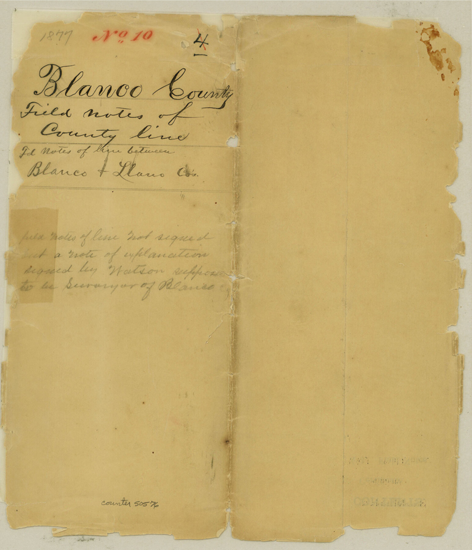
Blanco County Boundary File 10
Field notes & sketch of line between Blanco & Llano Counties
-
Map/Doc
50576
-
Collection
General Map Collection
-
Counties
Blanco
-
Subjects
County Boundaries
-
Height x Width
8.9 x 7.6 inches
22.6 x 19.3 cm
Part of: General Map Collection
Travis County Rolled Sketch 26

Print $20.00
- Digital $50.00
Travis County Rolled Sketch 26
1945
Size 24.6 x 25.2 inches
Map/Doc 8028
Travis County State Real Property Sketch 10

Print $20.00
- Digital $50.00
Travis County State Real Property Sketch 10
2002
Size 35.5 x 25.2 inches
Map/Doc 83550
Tarrant County Working Sketch 12

Print $20.00
- Digital $50.00
Tarrant County Working Sketch 12
1986
Size 30.8 x 23.4 inches
Map/Doc 62429
Goliad County Working Sketch 13

Print $20.00
- Digital $50.00
Goliad County Working Sketch 13
1943
Size 28.3 x 40.8 inches
Map/Doc 63203
Brewster County Working Sketch 15

Print $20.00
- Digital $50.00
Brewster County Working Sketch 15
1929
Size 30.4 x 40.9 inches
Map/Doc 67548
Bastrop County, From McDade to Austin, Texas, Houston & Texas Central Railroad

Print $20.00
- Digital $50.00
Bastrop County, From McDade to Austin, Texas, Houston & Texas Central Railroad
1939
Size 26.6 x 15.5 inches
Map/Doc 64364
Matagorda County Working Sketch 23

Print $20.00
- Digital $50.00
Matagorda County Working Sketch 23
1968
Size 27.4 x 35.8 inches
Map/Doc 70881
Young County Sketch File 8

Print $20.00
- Digital $50.00
Young County Sketch File 8
1856
Size 19.8 x 17.7 inches
Map/Doc 12710
Wise County Working Sketch 3

Print $20.00
- Digital $50.00
Wise County Working Sketch 3
1946
Size 28.4 x 36.9 inches
Map/Doc 72617
Atascosa County Working Sketch 9

Print $20.00
- Digital $50.00
Atascosa County Working Sketch 9
1914
Size 16.5 x 14.6 inches
Map/Doc 67205
Terrell County Working Sketch 58

Print $40.00
- Digital $50.00
Terrell County Working Sketch 58
1960
Size 36.3 x 48.9 inches
Map/Doc 69579
Morris County Rolled Sketch 2A

Print $20.00
- Digital $50.00
Morris County Rolled Sketch 2A
Size 24.0 x 18.7 inches
Map/Doc 10260
You may also like
Hood County Working Sketch 23

Print $20.00
- Digital $50.00
Hood County Working Sketch 23
1993
Size 23.6 x 32.9 inches
Map/Doc 66217
King County Sketch File 11

Print $40.00
- Digital $50.00
King County Sketch File 11
1902
Size 13.7 x 9.1 inches
Map/Doc 29085
Presidio County Sketch File 122

Print $22.00
- Digital $50.00
Presidio County Sketch File 122
2010
Size 11.0 x 8.5 inches
Map/Doc 89604
Hardin County Rolled Sketch 11

Print $20.00
- Digital $50.00
Hardin County Rolled Sketch 11
1948
Size 20.8 x 38.6 inches
Map/Doc 6083
Minutes of the Ayuntamiento of San Felipe de Austin Vol. 2

Minutes of the Ayuntamiento of San Felipe de Austin Vol. 2
Size 13.3 x 10.5 inches
Map/Doc 94261
Flight Mission No. CRC-3R, Frame 8, Chambers County

Print $20.00
- Digital $50.00
Flight Mission No. CRC-3R, Frame 8, Chambers County
1956
Size 18.6 x 22.2 inches
Map/Doc 84782
[Part of Block K4]
![90526, [Part of Block K4], Twichell Survey Records](https://historictexasmaps.com/wmedia_w700/maps/90526-1.tif.jpg)
Print $3.00
- Digital $50.00
[Part of Block K4]
Size 9.6 x 11.7 inches
Map/Doc 90526
Sherman County Rolled Sketch 9

Print $20.00
- Digital $50.00
Sherman County Rolled Sketch 9
1942
Size 33.5 x 26.7 inches
Map/Doc 7789
Brooks County Sketch File 3

Print $40.00
- Digital $50.00
Brooks County Sketch File 3
Size 21.5 x 19.0 inches
Map/Doc 11016
Bexar County Sketch File 58a

Print $4.00
- Digital $50.00
Bexar County Sketch File 58a
1847
Size 10.2 x 8.2 inches
Map/Doc 14574
[C.C.S.D. & R.G.N.G. RR. Co. Blk. G east thru T.&P. Blk 33]
![89775, [C.C.S.D. & R.G.N.G. RR. Co. Blk. G east thru T.&P. Blk 33], Twichell Survey Records](https://historictexasmaps.com/wmedia_w700/maps/89775-1.tif.jpg)
Print $40.00
- Digital $50.00
[C.C.S.D. & R.G.N.G. RR. Co. Blk. G east thru T.&P. Blk 33]
1901
Size 70.2 x 23.0 inches
Map/Doc 89775
Childress County Sketch File 4

Print $24.00
- Digital $50.00
Childress County Sketch File 4
1887
Size 8.1 x 12.0 inches
Map/Doc 18250