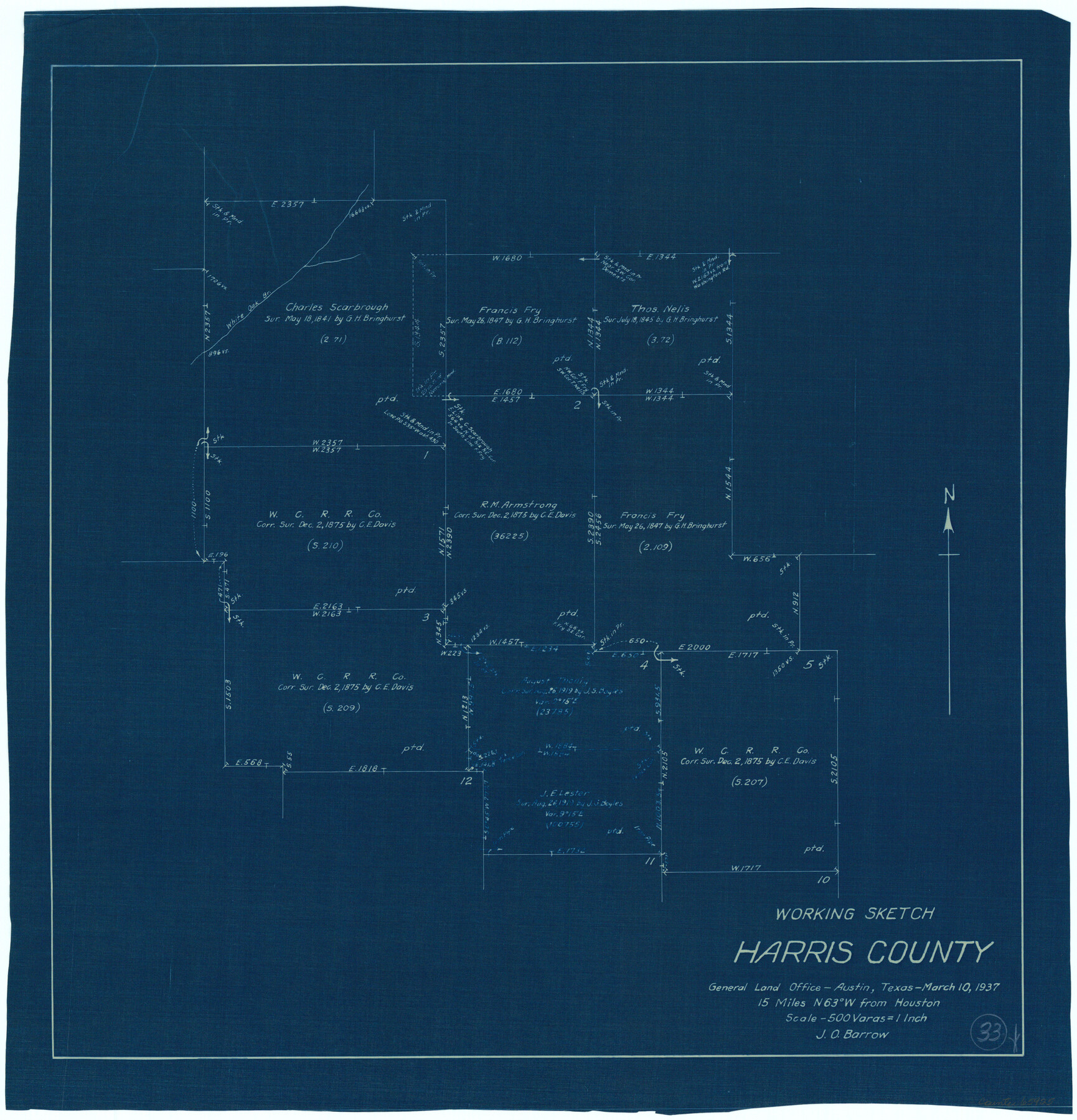
Harris County Working Sketch 33
-
Map/Doc
65925
-
Collection
General Map Collection
-
Object Dates
3/10/1937 (Creation Date)
-
People and Organizations
J.O. Barrow (Draftsman)
-
Counties
Harris
-
Subjects
Surveying Working Sketch
-
Height x Width
21.4 x 20.6 inches
54.4 x 52.3 cm
-
Scale
1" = 500 varas
Part of: General Map Collection
Armstrong County Working Sketch 3

Print $20.00
- Digital $50.00
Armstrong County Working Sketch 3
1904
Size 46.1 x 40.8 inches
Map/Doc 67234
Fayette County Boundary File 3

Print $29.00
- Digital $50.00
Fayette County Boundary File 3
Size 14.4 x 9.0 inches
Map/Doc 53348
Knox County Boundary File 3

Print $54.00
- Digital $50.00
Knox County Boundary File 3
Size 8.9 x 7.7 inches
Map/Doc 65019
Terrell County Working Sketch 63

Print $20.00
- Digital $50.00
Terrell County Working Sketch 63
1970
Size 37.8 x 35.9 inches
Map/Doc 69584
Victoria County Sketch File V1

Print $10.00
- Digital $50.00
Victoria County Sketch File V1
1896
Size 14.6 x 9.2 inches
Map/Doc 39525
Frank Lerch's Map of San Angelo and Additions

Print $20.00
- Digital $50.00
Frank Lerch's Map of San Angelo and Additions
1880
Size 36.6 x 26.3 inches
Map/Doc 2188
El Paso County Sketch File 13

Print $8.00
- Digital $50.00
El Paso County Sketch File 13
1905
Size 7.4 x 6.8 inches
Map/Doc 22005
Brooks County Boundary File 3

Print $20.00
- Digital $50.00
Brooks County Boundary File 3
Size 42.1 x 6.6 inches
Map/Doc 50843
San Patricio County Sketch File 10

Print $8.00
San Patricio County Sketch File 10
1847
Size 13.3 x 8.4 inches
Map/Doc 36040
Bosque County Working Sketch 32

Print $20.00
- Digital $50.00
Bosque County Working Sketch 32
2014
Size 24.3 x 24.7 inches
Map/Doc 93687
Wood County Working Sketch 20

Print $40.00
- Digital $50.00
Wood County Working Sketch 20
1985
Size 42.6 x 48.6 inches
Map/Doc 62020
University Land in Cooke County

Print $20.00
- Digital $50.00
University Land in Cooke County
1906
Size 23.6 x 30.0 inches
Map/Doc 2425
You may also like
Right of Way & Track Map San Antonio & Aransas Pass Railway Co.

Print $40.00
- Digital $50.00
Right of Way & Track Map San Antonio & Aransas Pass Railway Co.
1919
Size 25.7 x 56.7 inches
Map/Doc 64039
The Chief Justice County of Mina. April 24, 1837

Print $20.00
The Chief Justice County of Mina. April 24, 1837
2020
Size 15.8 x 21.7 inches
Map/Doc 96061
Montague County Sketch File 10

Print $4.00
- Digital $50.00
Montague County Sketch File 10
1873
Size 7.9 x 11.8 inches
Map/Doc 31732
Flight Mission No. DAH-17M, Frame 31, Orange County

Print $20.00
- Digital $50.00
Flight Mission No. DAH-17M, Frame 31, Orange County
1953
Size 18.7 x 22.5 inches
Map/Doc 86894
Brewster County Rolled Sketch 114

Print $20.00
- Digital $50.00
Brewster County Rolled Sketch 114
1964
Size 11.4 x 18.4 inches
Map/Doc 5277
Travis County State Real Property Sketch 4

Print $20.00
- Digital $50.00
Travis County State Real Property Sketch 4
1987
Size 25.7 x 30.7 inches
Map/Doc 61695
Frio County Rolled Sketch 10

Print $20.00
- Digital $50.00
Frio County Rolled Sketch 10
1945
Size 34.0 x 35.7 inches
Map/Doc 8902
Winkler County Sketch File 3

Print $20.00
- Digital $50.00
Winkler County Sketch File 3
Size 38.6 x 33.8 inches
Map/Doc 10436
Hudspeth County Working Sketch 4

Print $20.00
- Digital $50.00
Hudspeth County Working Sketch 4
1914
Size 16.9 x 20.5 inches
Map/Doc 66285
Duval County Rolled Sketch 40

Print $20.00
- Digital $50.00
Duval County Rolled Sketch 40
1958
Size 22.8 x 31.1 inches
Map/Doc 5757
Crockett County Working Sketch 93

Print $40.00
- Digital $50.00
Crockett County Working Sketch 93
1979
Size 43.5 x 65.4 inches
Map/Doc 68426
Clay County Sketch File 43

Print $40.00
- Digital $50.00
Clay County Sketch File 43
1891
Size 23.2 x 33.7 inches
Map/Doc 11094