Victoria County Sketch File V1
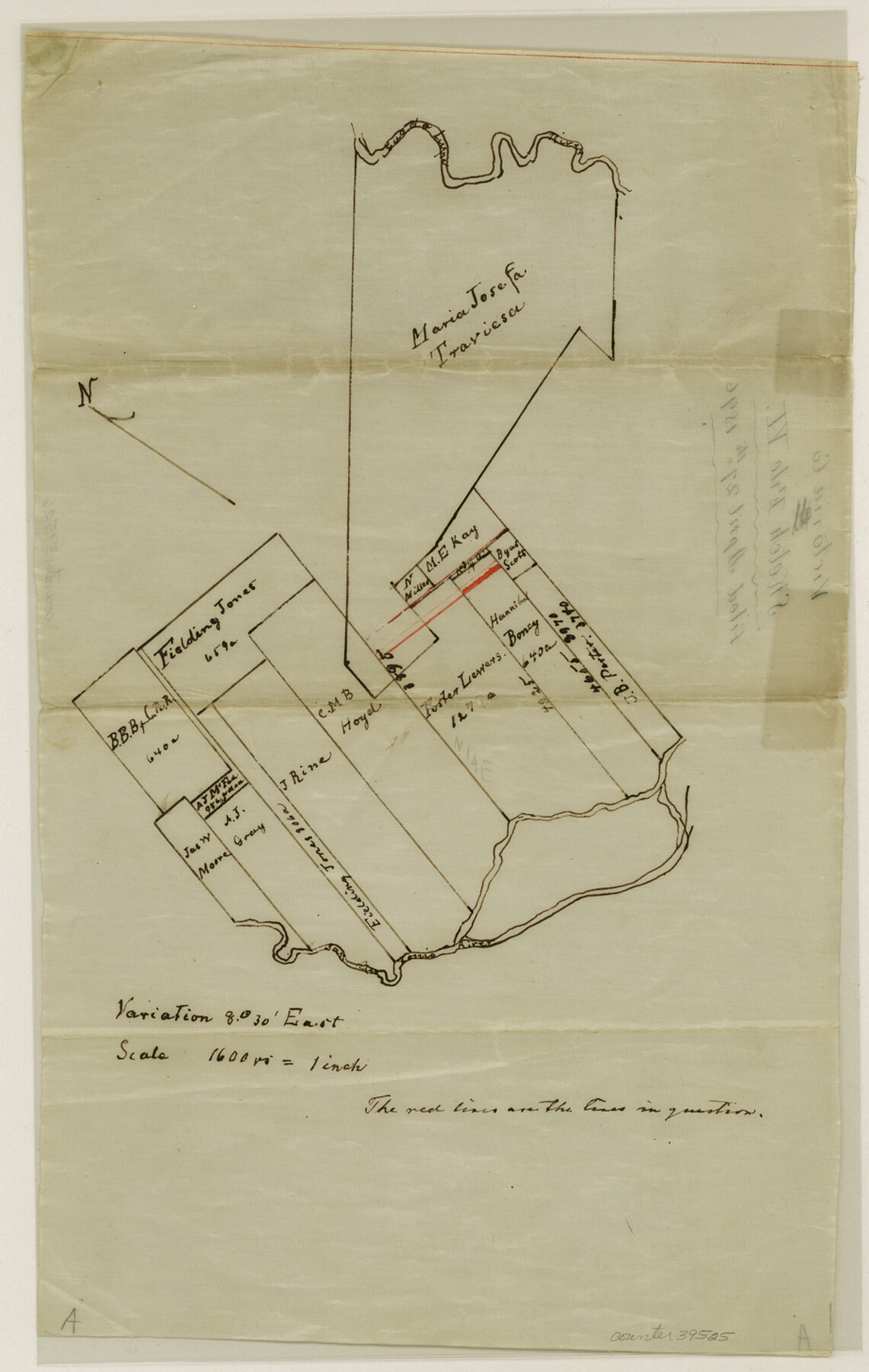
[Sketch and explanation of surveys on the north side of the San Antonio River in the south part of the county]
-
Map/Doc
39525
-
Collection
General Map Collection
-
Object Dates
4/10/1896 (Creation Date)
4/27/1896 (File Date)
-
People and Organizations
M. Stuart (Surveyor/Engineer)
-
Counties
Victoria
-
Subjects
Surveying Sketch File
-
Height x Width
14.6 x 9.2 inches
37.1 x 23.4 cm
-
Medium
paper, manuscript
-
Scale
1" = 1600 varas
-
Features
San Antonio River
Guadalupe River
Part of: General Map Collection
Parker County Working Sketch Graphic Index

Print $20.00
- Digital $50.00
Parker County Working Sketch Graphic Index
1942
Map/Doc 76661
Calhoun County NRC Article 33.136 Sketch 11

Digital $50.00
Calhoun County NRC Article 33.136 Sketch 11
2023
Map/Doc 97255
Galveston Island

Print $20.00
- Digital $50.00
Galveston Island
1837
Size 24.1 x 37.2 inches
Map/Doc 2009
Brazos County Sketch File 2

Print $4.00
- Digital $50.00
Brazos County Sketch File 2
1858
Size 7.9 x 9.4 inches
Map/Doc 15552
Voyages Autour du Monde, et vers les deux poles par terre et par mer - Tome Premier

Voyages Autour du Monde, et vers les deux poles par terre et par mer - Tome Premier
1782
Map/Doc 97085
Angelina County Working Sketch 51

Print $20.00
- Digital $50.00
Angelina County Working Sketch 51
1988
Size 44.0 x 23.0 inches
Map/Doc 67135
Bosque County Sketch File 2

Print $4.00
- Digital $50.00
Bosque County Sketch File 2
1847
Size 7.8 x 12.4 inches
Map/Doc 14740
Brazoria County Working Sketch 50b

Print $20.00
- Digital $50.00
Brazoria County Working Sketch 50b
2003
Size 34.8 x 34.6 inches
Map/Doc 78345
Val Verde County Rolled Sketch 10

Print $20.00
- Digital $50.00
Val Verde County Rolled Sketch 10
Size 22.9 x 27.8 inches
Map/Doc 8108
Map of Texas with Parts of the Adjoining States

Print $20.00
- Digital $50.00
Map of Texas with Parts of the Adjoining States
1837
Size 31.5 x 24.9 inches
Map/Doc 2114
Galveston County Rolled Sketch 22

Print $20.00
- Digital $50.00
Galveston County Rolled Sketch 22
1953
Size 28.8 x 39.5 inches
Map/Doc 9663
Lampasas County Boundary File 16

Print $14.00
- Digital $50.00
Lampasas County Boundary File 16
Size 8.9 x 8.2 inches
Map/Doc 56216
You may also like
Jasper County Working Sketch 29

Print $20.00
- Digital $50.00
Jasper County Working Sketch 29
1956
Size 20.6 x 31.4 inches
Map/Doc 66491
Castro County Sketch File 4a

Print $4.00
- Digital $50.00
Castro County Sketch File 4a
Size 6.2 x 8.5 inches
Map/Doc 17465
Polk County Sketch File 23

Print $20.00
- Digital $50.00
Polk County Sketch File 23
Size 18.0 x 18.6 inches
Map/Doc 12191
Yellow Fever Deaths in Texas and Louisiana

Yellow Fever Deaths in Texas and Louisiana
2022
Size 8.5 x 11.0 inches
Map/Doc 97094
General Highway Map, Williamson County, Texas

Print $20.00
General Highway Map, Williamson County, Texas
1961
Size 24.8 x 18.2 inches
Map/Doc 79713
Baylor County Rolled Sketch 8

Print $20.00
- Digital $50.00
Baylor County Rolled Sketch 8
1883
Size 12.9 x 18.4 inches
Map/Doc 5124
Flight Mission No. DQN-7K, Frame 36, Calhoun County

Print $20.00
- Digital $50.00
Flight Mission No. DQN-7K, Frame 36, Calhoun County
1953
Size 18.5 x 22.2 inches
Map/Doc 84474
Upton County Sketch File 12

Print $20.00
- Digital $50.00
Upton County Sketch File 12
1926
Size 20.6 x 34.8 inches
Map/Doc 12512

Atascosa County Working Sketch 15

Print $40.00
- Digital $50.00
Atascosa County Working Sketch 15
1935
Size 43.8 x 53.6 inches
Map/Doc 67211
General Highway Map, Jefferson County, Texas

Print $20.00
General Highway Map, Jefferson County, Texas
1961
Size 24.6 x 18.3 inches
Map/Doc 79537
Presidio County Working Sketch 89

Print $20.00
- Digital $50.00
Presidio County Working Sketch 89
1972
Size 28.8 x 37.5 inches
Map/Doc 71766