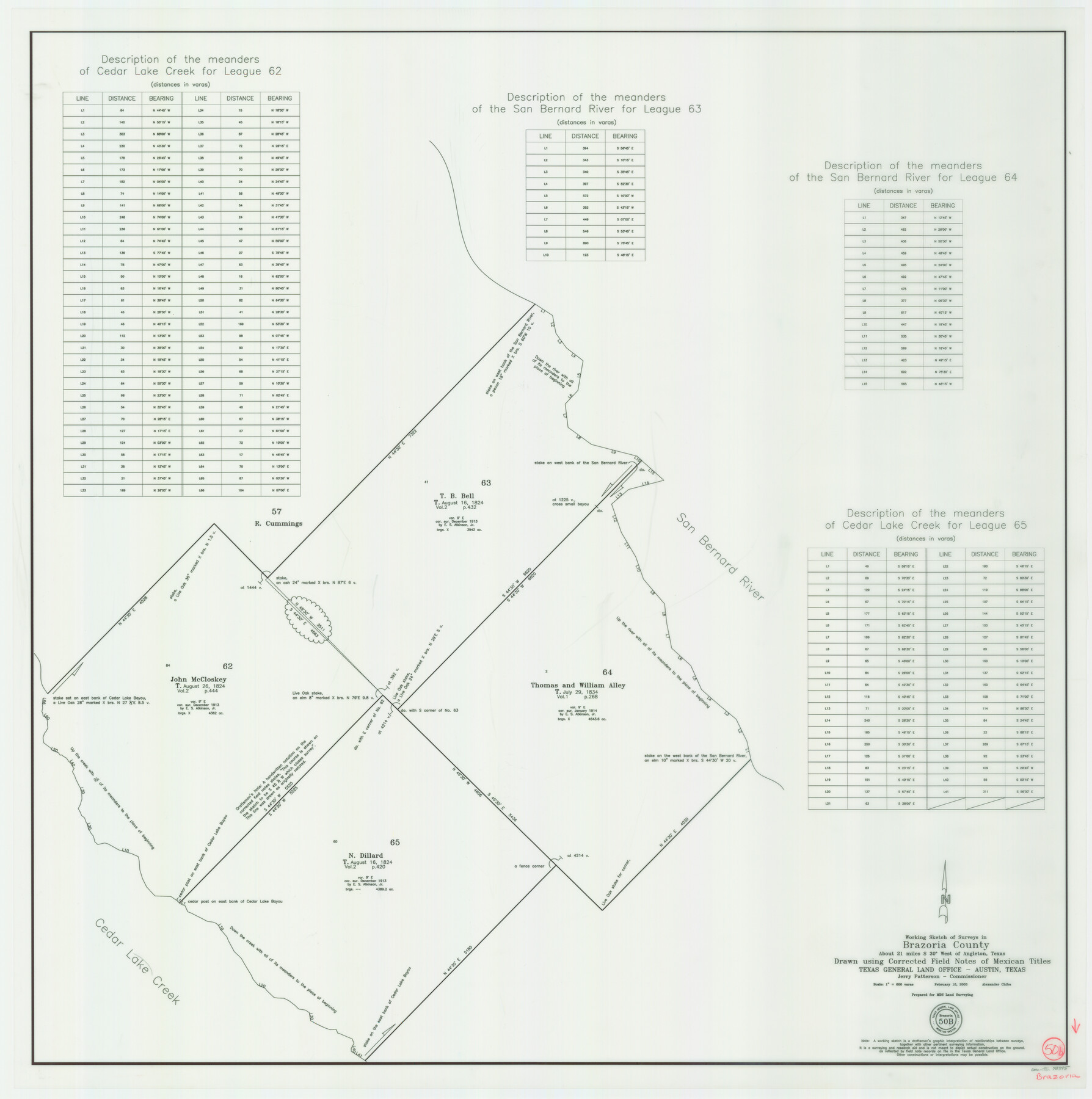
Brazoria County Working Sketch 50b
-
Map/Doc
78345
-
Collection
General Map Collection
-
Object Dates
2/18/2003 (Creation Date)
-
People and Organizations
Jerry E. Patterson (GLO Commissioner)
Alex Chiba (Draftsman)
-
Counties
Brazoria
-
Subjects
Surveying Working Sketch
-
Height x Width
34.8 x 34.6 inches
88.4 x 87.9 cm
-
Scale
1" = 600 varas
-
Comments
Surveys located about 21 miles South 30 degrees West of Angleton, Texas.
Part of: General Map Collection
Flight Mission No. DQN-7K, Frame 3, Calhoun County

Print $20.00
- Digital $50.00
Flight Mission No. DQN-7K, Frame 3, Calhoun County
1953
Size 18.5 x 22.2 inches
Map/Doc 84454
Reagan County

Print $40.00
- Digital $50.00
Reagan County
1915
Size 48.8 x 36.0 inches
Map/Doc 78429
Panola County Working Sketch Graphic Index

Print $20.00
- Digital $50.00
Panola County Working Sketch Graphic Index
1947
Map/Doc 76660
Edwards County Working Sketch 79

Print $40.00
- Digital $50.00
Edwards County Working Sketch 79
1962
Size 58.5 x 26.6 inches
Map/Doc 68955
Hays County Boundary File 1

Print $14.00
- Digital $50.00
Hays County Boundary File 1
Size 9.5 x 5.2 inches
Map/Doc 54586
Val Verde County Working Sketch 24

Print $20.00
- Digital $50.00
Val Verde County Working Sketch 24
1936
Size 21.5 x 21.6 inches
Map/Doc 72159
Kinney County Rolled Sketch 9

Print $20.00
- Digital $50.00
Kinney County Rolled Sketch 9
Size 39.4 x 27.5 inches
Map/Doc 6538
Coast Chart No. 212 - From Latitude 26° 33' to the Rio Grande Texas

Print $20.00
- Digital $50.00
Coast Chart No. 212 - From Latitude 26° 33' to the Rio Grande Texas
1886
Size 27.2 x 18.2 inches
Map/Doc 72830
[Surveys along the Sabine River made under G.W. Smyth, Commissioner]
![90, [Surveys along the Sabine River made under G.W. Smyth, Commissioner], General Map Collection](https://historictexasmaps.com/wmedia_w700/maps/90.tif.jpg)
Print $20.00
- Digital $50.00
[Surveys along the Sabine River made under G.W. Smyth, Commissioner]
1837
Size 13.9 x 17.0 inches
Map/Doc 90
Briscoe County Sketch File 14

Print $20.00
- Digital $50.00
Briscoe County Sketch File 14
1910
Size 14.2 x 8.5 inches
Map/Doc 16509

Navarro County Sketch File 10

Print $4.00
- Digital $50.00
Navarro County Sketch File 10
1860
Size 12.6 x 8.2 inches
Map/Doc 32318
You may also like
General Highway Map, Medina County, Texas

Print $20.00
General Highway Map, Medina County, Texas
1940
Size 18.3 x 24.6 inches
Map/Doc 79195
Mills County Boundary File 5b

Print $8.00
- Digital $50.00
Mills County Boundary File 5b
Size 14.2 x 8.7 inches
Map/Doc 57307
Polk County Rolled Sketch TMS

Print $40.00
- Digital $50.00
Polk County Rolled Sketch TMS
1937
Size 35.7 x 56.5 inches
Map/Doc 9756
Val Verde County Rolled Sketch 67

Print $20.00
- Digital $50.00
Val Verde County Rolled Sketch 67
1958
Size 24.5 x 31.6 inches
Map/Doc 8130
Buenaventura Reyes Grants

Print $20.00
- Digital $50.00
Buenaventura Reyes Grants
1896
Size 14.9 x 13.5 inches
Map/Doc 2057
Flight Mission No. BRE-1P, Frame 117, Nueces County

Print $20.00
- Digital $50.00
Flight Mission No. BRE-1P, Frame 117, Nueces County
1956
Size 18.4 x 22.3 inches
Map/Doc 86683
Flight Mission No. DCL-6C, Frame 16, Kenedy County

Print $20.00
- Digital $50.00
Flight Mission No. DCL-6C, Frame 16, Kenedy County
1943
Size 18.7 x 22.3 inches
Map/Doc 85873
Flight Mission No. BRA-8M, Frame 27, Jefferson County

Print $20.00
- Digital $50.00
Flight Mission No. BRA-8M, Frame 27, Jefferson County
1953
Size 18.6 x 22.3 inches
Map/Doc 85582
Flight Mission No. CRK-3P, Frame 126, Refugio County

Print $20.00
- Digital $50.00
Flight Mission No. CRK-3P, Frame 126, Refugio County
1956
Size 18.6 x 22.4 inches
Map/Doc 86914
Pecos County Sketch File 65

Print $6.00
- Digital $50.00
Pecos County Sketch File 65
1919
Size 16.7 x 11.9 inches
Map/Doc 33824
Liberty County Working Sketch 88

Print $20.00
- Digital $50.00
Liberty County Working Sketch 88
1991
Size 19.6 x 38.8 inches
Map/Doc 70548
[I. & G. N, Sections 8-13]
![91047, [I. & G. N, Sections 8-13], Twichell Survey Records](https://historictexasmaps.com/wmedia_w700/maps/91047-1.tif.jpg)
Print $20.00
- Digital $50.00
[I. & G. N, Sections 8-13]
Size 25.2 x 12.1 inches
Map/Doc 91047