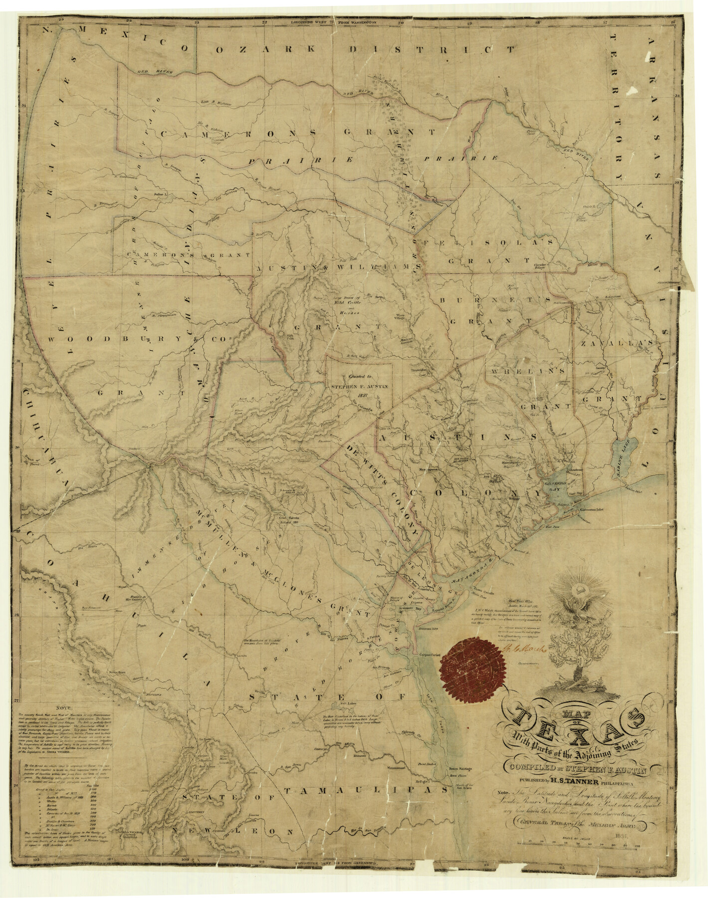
Map of Texas with Parts of the Adjoining States
K-4-5a
-
Map/Doc
2114
-
Collection
General Map Collection
-
Object Dates
1837 (Creation Date)
-
People and Organizations
H. S. Tanner (Publisher)
Stephen F. Austin (Compiler)
-
Subjects
Republic of Texas
-
Height x Width
31.5 x 24.9 inches
80.0 x 63.2 cm
-
Comments
Traced in 1882 by F. G. Blau.
Conservation funded in 2001 with donation from Gerald L. Atkinson. -
Features
ACRR
Part of: General Map Collection

Clay County Sketch File 35

Print $3.00
- Digital $50.00
Clay County Sketch File 35
Size 10.3 x 12.1 inches
Map/Doc 18463
Flight Mission No. DQO-12K, Frame 35, Galveston County

Print $20.00
- Digital $50.00
Flight Mission No. DQO-12K, Frame 35, Galveston County
1952
Size 18.7 x 22.4 inches
Map/Doc 85226
Stephens County Boundary File 1

Print $22.00
- Digital $50.00
Stephens County Boundary File 1
Size 14.1 x 8.9 inches
Map/Doc 58856
Hardin County Sketch File 17

Print $6.00
- Digital $50.00
Hardin County Sketch File 17
1854
Size 15.9 x 9.9 inches
Map/Doc 25130
Map of Hopkins Co.

Print $20.00
- Digital $50.00
Map of Hopkins Co.
1885
Size 34.0 x 33.9 inches
Map/Doc 16854
Donley County Working Sketch 5

Print $40.00
- Digital $50.00
Donley County Working Sketch 5
1957
Size 54.8 x 32.2 inches
Map/Doc 62185
Galveston County Sketch File 61a

Print $12.00
- Digital $50.00
Galveston County Sketch File 61a
1988
Size 11.2 x 8.8 inches
Map/Doc 23665
Grayson County Rolled Sketch 4

Print $20.00
- Digital $50.00
Grayson County Rolled Sketch 4
1953
Size 26.0 x 27.7 inches
Map/Doc 6031
Wise County Working Sketch 19

Print $20.00
- Digital $50.00
Wise County Working Sketch 19
1978
Size 28.6 x 32.5 inches
Map/Doc 72633
Map of Hill County

Print $20.00
- Digital $50.00
Map of Hill County
1857
Size 21.5 x 25.6 inches
Map/Doc 3672
Foard County Sketch File 19

Print $20.00
- Digital $50.00
Foard County Sketch File 19
1899
Size 17.7 x 16.5 inches
Map/Doc 11493
You may also like
Montgomery County Texas Historical Map

Montgomery County Texas Historical Map
Size 23.2 x 35.3 inches
Map/Doc 94404
Hardeman County Sketch File 17

Print $2.00
- Digital $50.00
Hardeman County Sketch File 17
Size 7.8 x 6.7 inches
Map/Doc 25025
Garza County Rolled Sketch J

Print $20.00
- Digital $50.00
Garza County Rolled Sketch J
1911
Size 27.2 x 23.4 inches
Map/Doc 6004
Harris County Working Sketch 29

Print $20.00
- Digital $50.00
Harris County Working Sketch 29
1934
Size 22.6 x 30.5 inches
Map/Doc 65921

Houston County Sketch File 1b

Print $4.00
- Digital $50.00
Houston County Sketch File 1b
1857
Size 8.5 x 7.9 inches
Map/Doc 26744
Right of Way and Track Map Houston & Texas Central R.R. operated by the T. and N. O. R.R. Co., Fort Worth Branch

Print $40.00
- Digital $50.00
Right of Way and Track Map Houston & Texas Central R.R. operated by the T. and N. O. R.R. Co., Fort Worth Branch
1918
Size 30.7 x 56.4 inches
Map/Doc 64542
Brazos River, Brazos River Sheet 5

Print $20.00
- Digital $50.00
Brazos River, Brazos River Sheet 5
1926
Size 27.4 x 21.7 inches
Map/Doc 69669
[Sketch for Mineral Application 26501 - Sabine River, T. A. Oldhausen]
![2840, [Sketch for Mineral Application 26501 - Sabine River, T. A. Oldhausen], General Map Collection](https://historictexasmaps.com/wmedia_w700/maps/2840.tif.jpg)
Print $20.00
- Digital $50.00
[Sketch for Mineral Application 26501 - Sabine River, T. A. Oldhausen]
1931
Size 24.3 x 35.5 inches
Map/Doc 2840
Kaufman County State Real Property Sketch 1

Print $92.00
- Digital $50.00
Kaufman County State Real Property Sketch 1
2006
Size 24.6 x 35.4 inches
Map/Doc 88624
J No. 5 - Reconnaissance of San Clemente Harbor, California / Reconnaissance of Prisoner's Harbor, California / Reconnaissance of Cuyler's Harbor, Island of San Miguel, California

Print $20.00
- Digital $50.00
J No. 5 - Reconnaissance of San Clemente Harbor, California / Reconnaissance of Prisoner's Harbor, California / Reconnaissance of Cuyler's Harbor, Island of San Miguel, California
1852
Size 19.2 x 16.5 inches
Map/Doc 97234
Starr County Sketch File 31B

Print $14.00
- Digital $50.00
Starr County Sketch File 31B
1936
Size 14.2 x 8.8 inches
Map/Doc 36960