Castro County Sketch File 4a
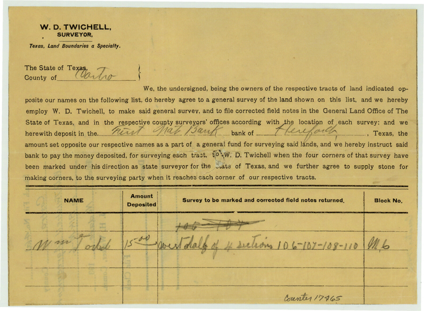
[Agreement for W.D. Twichell to survey the west half of four sections: 106, 107, 108, and 110 in Block M6]
-
Map/Doc
17465
-
Collection
General Map Collection
-
People and Organizations
W.D. Twichell (Surveyor/Engineer)
-
Counties
Castro
-
Subjects
Surveying Sketch File
-
Height x Width
6.2 x 8.5 inches
15.7 x 21.6 cm
-
Medium
paper, print with manuscript additions
Part of: General Map Collection
Brewster County Rolled Sketch 127

Print $20.00
- Digital $50.00
Brewster County Rolled Sketch 127
1969
Size 39.0 x 43.8 inches
Map/Doc 8521
Stonewall County Boundary File 4a

Print $18.00
- Digital $50.00
Stonewall County Boundary File 4a
Size 14.2 x 8.8 inches
Map/Doc 58984
Montgomery County Sketch File 2

Print $8.00
- Digital $50.00
Montgomery County Sketch File 2
1846
Size 12.7 x 8.0 inches
Map/Doc 31764
Ward County Sketch File 6

Print $20.00
- Digital $50.00
Ward County Sketch File 6
Size 21.6 x 45.5 inches
Map/Doc 10427
Henderson County Rolled Sketch 11

Print $20.00
- Digital $50.00
Henderson County Rolled Sketch 11
1915
Size 29.1 x 42.2 inches
Map/Doc 76150
[Sketch for Mineral Application 24072, San Jacinto River]
![65598, [Sketch for Mineral Application 24072, San Jacinto River], General Map Collection](https://historictexasmaps.com/wmedia_w700/maps/65598.tif.jpg)
Print $20.00
- Digital $50.00
[Sketch for Mineral Application 24072, San Jacinto River]
1929
Size 24.6 x 18.3 inches
Map/Doc 65598
Pecos County Sketch File 93

Print $46.00
- Digital $50.00
Pecos County Sketch File 93
1955
Size 9.6 x 8.3 inches
Map/Doc 33990
Dallas County Boundary File 7 and 7a and 7b

Print $26.00
- Digital $50.00
Dallas County Boundary File 7 and 7a and 7b
Size 11.2 x 8.6 inches
Map/Doc 52278
Hall County Sketch File 6

Print $20.00
- Digital $50.00
Hall County Sketch File 6
1885
Size 28.2 x 37.9 inches
Map/Doc 10473
Flight Mission No. DCL-6C, Frame 54, Kenedy County

Print $20.00
- Digital $50.00
Flight Mission No. DCL-6C, Frame 54, Kenedy County
1943
Size 18.6 x 22.4 inches
Map/Doc 85896
Maps of Gulf Intracoastal Waterway, Texas - Sabine River to the Rio Grande and connecting waterways including ship channels

Print $20.00
- Digital $50.00
Maps of Gulf Intracoastal Waterway, Texas - Sabine River to the Rio Grande and connecting waterways including ship channels
1966
Size 14.5 x 22.3 inches
Map/Doc 61944
Galveston County NRC Article 33.136 Sketch 69

Print $76.00
- Digital $50.00
Galveston County NRC Article 33.136 Sketch 69
2012
Size 24.0 x 36.0 inches
Map/Doc 94669
You may also like
Brewster County Working Sketch 48

Print $20.00
- Digital $50.00
Brewster County Working Sketch 48
1949
Size 28.9 x 23.7 inches
Map/Doc 67582
Carte Reduite du Globe Terrestre

Print $20.00
- Digital $50.00
Carte Reduite du Globe Terrestre
1782
Size 13.5 x 17.1 inches
Map/Doc 97117
Terrell County Working Sketch 31

Print $20.00
- Digital $50.00
Terrell County Working Sketch 31
1945
Size 26.8 x 27.8 inches
Map/Doc 62123
El Paso County Sketch File 37

Print $4.00
- Digital $50.00
El Paso County Sketch File 37
1987
Size 14.4 x 9.1 inches
Map/Doc 22221
Brazos Santiago, Texas

Print $20.00
- Digital $50.00
Brazos Santiago, Texas
1867
Size 27.1 x 18.3 inches
Map/Doc 73035
Pecos County Sketch File 20

Print $20.00
- Digital $50.00
Pecos County Sketch File 20
Size 25.9 x 12.0 inches
Map/Doc 12160
Texas Gulf Coast from the Sabine River to the Rio Grande Showing Location of Navigation Districts

Print $20.00
- Digital $50.00
Texas Gulf Coast from the Sabine River to the Rio Grande Showing Location of Navigation Districts
1954
Size 45.0 x 43.8 inches
Map/Doc 73596
Map of Lampasas County

Print $20.00
- Digital $50.00
Map of Lampasas County
1864
Size 20.5 x 24.8 inches
Map/Doc 3793
Hays County Working Sketch 17

Print $20.00
- Digital $50.00
Hays County Working Sketch 17
1971
Size 28.6 x 30.0 inches
Map/Doc 66091
Travis County Sketch File 3

Print $4.00
- Digital $50.00
Travis County Sketch File 3
Size 12.9 x 7.9 inches
Map/Doc 38273
Map of Montgomery County

Print $40.00
- Digital $50.00
Map of Montgomery County
1844
Size 56.6 x 41.3 inches
Map/Doc 78671
Sutton County Working Sketch 15

Print $40.00
- Digital $50.00
Sutton County Working Sketch 15
1972
Size 37.0 x 81.1 inches
Map/Doc 62358