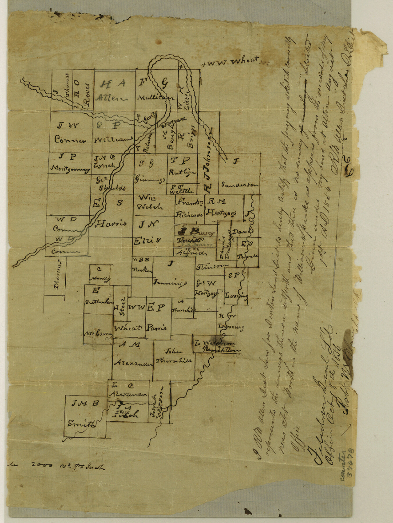
Tarrant County Sketch File 4
[Sketch of surveys near the center of the county]
-
Map/Doc
37678
-
Collection
General Map Collection
-
Object Dates
8/1/1856 (Creation Date)
10/24/1856 (File Date)
-
People and Organizations
R.W. Allen (Surveyor/Engineer)
-
Counties
Tarrant
-
Subjects
Surveying Sketch File
-
Height x Width
11.8 x 8.9 inches
30.0 x 22.6 cm
-
Medium
paper, manuscript
-
Scale
1" = 2000 varas
Part of: General Map Collection
Duval County Rolled Sketch 37

Print $20.00
- Digital $50.00
Duval County Rolled Sketch 37
Size 27.1 x 17.9 inches
Map/Doc 5752
Comal County Sketch File 6

Print $6.00
- Digital $50.00
Comal County Sketch File 6
Size 10.3 x 8.1 inches
Map/Doc 19008
Chambers County Working Sketch 3

Print $20.00
- Digital $50.00
Chambers County Working Sketch 3
1935
Size 35.9 x 38.8 inches
Map/Doc 67986
Motley County Sketch File 22 (N)

Print $34.00
- Digital $50.00
Motley County Sketch File 22 (N)
1887
Size 8.2 x 8.4 inches
Map/Doc 32069
Hemphill County Rolled Sketch 17

Print $20.00
- Digital $50.00
Hemphill County Rolled Sketch 17
1965
Size 23.5 x 39.9 inches
Map/Doc 6199
Mason County Sketch File 7

Print $4.00
- Digital $50.00
Mason County Sketch File 7
Size 7.9 x 8.8 inches
Map/Doc 30689
Liberty County Sketch File 21

Print $5.00
- Digital $50.00
Liberty County Sketch File 21
1858
Size 7.9 x 13.0 inches
Map/Doc 29928
Flight Mission No. DAG-17K, Frame 61, Matagorda County

Print $20.00
- Digital $50.00
Flight Mission No. DAG-17K, Frame 61, Matagorda County
1952
Size 16.4 x 16.4 inches
Map/Doc 86323
Denton County Sketch File 11

Print $4.00
- Digital $50.00
Denton County Sketch File 11
1856
Size 5.1 x 8.6 inches
Map/Doc 20709
Brazoria County

Print $40.00
- Digital $50.00
Brazoria County
1891
Size 47.1 x 54.2 inches
Map/Doc 4890
Kerr County Boundary File 4a

Print $16.00
- Digital $50.00
Kerr County Boundary File 4a
Size 6.1 x 8.2 inches
Map/Doc 64801
Cram's Superior Map of Illinois

Print $40.00
- Digital $50.00
Cram's Superior Map of Illinois
1903
Size 50.2 x 40.5 inches
Map/Doc 97110
You may also like
El Paso County Working Sketch 10

Print $20.00
- Digital $50.00
El Paso County Working Sketch 10
1955
Size 31.1 x 20.5 inches
Map/Doc 69032
Colorado River, El Campo Sheet

Print $6.00
- Digital $50.00
Colorado River, El Campo Sheet
1939
Size 27.4 x 35.2 inches
Map/Doc 65318
Wise County Working Sketch 10

Print $20.00
- Digital $50.00
Wise County Working Sketch 10
Size 17.4 x 18.4 inches
Map/Doc 72624
Cass County Working Sketch 9

Print $20.00
- Digital $50.00
Cass County Working Sketch 9
1937
Size 28.4 x 32.7 inches
Map/Doc 67912
Hale County Working Sketch Graphic Index

Print $20.00
- Digital $50.00
Hale County Working Sketch Graphic Index
1931
Size 46.4 x 36.9 inches
Map/Doc 76562
El Paso County Rolled Sketch 54

Print $20.00
- Digital $50.00
El Paso County Rolled Sketch 54
1980
Size 30.4 x 42.8 inches
Map/Doc 44539
[St. Louis & Southwestern]
![64278, [St. Louis & Southwestern], General Map Collection](https://historictexasmaps.com/wmedia_w700/maps/64278.tif.jpg)
Print $20.00
- Digital $50.00
[St. Louis & Southwestern]
Size 20.8 x 28.9 inches
Map/Doc 64278
Van Zandt County Sketch File 29c

Print $4.00
- Digital $50.00
Van Zandt County Sketch File 29c
1861
Size 8.2 x 8.3 inches
Map/Doc 39459
Refugio County Working Sketch 16

Print $20.00
- Digital $50.00
Refugio County Working Sketch 16
1965
Size 34.0 x 31.8 inches
Map/Doc 63525
Aransas Pass to Baffin Bay

Print $40.00
- Digital $50.00
Aransas Pass to Baffin Bay
1988
Size 48.7 x 36.0 inches
Map/Doc 73422
Fannin County Working Sketch 6

Print $20.00
- Digital $50.00
Fannin County Working Sketch 6
1939
Size 11.4 x 18.0 inches
Map/Doc 69160
Marion County Working Sketch 29

Print $20.00
- Digital $50.00
Marion County Working Sketch 29
1977
Size 20.4 x 16.1 inches
Map/Doc 70805