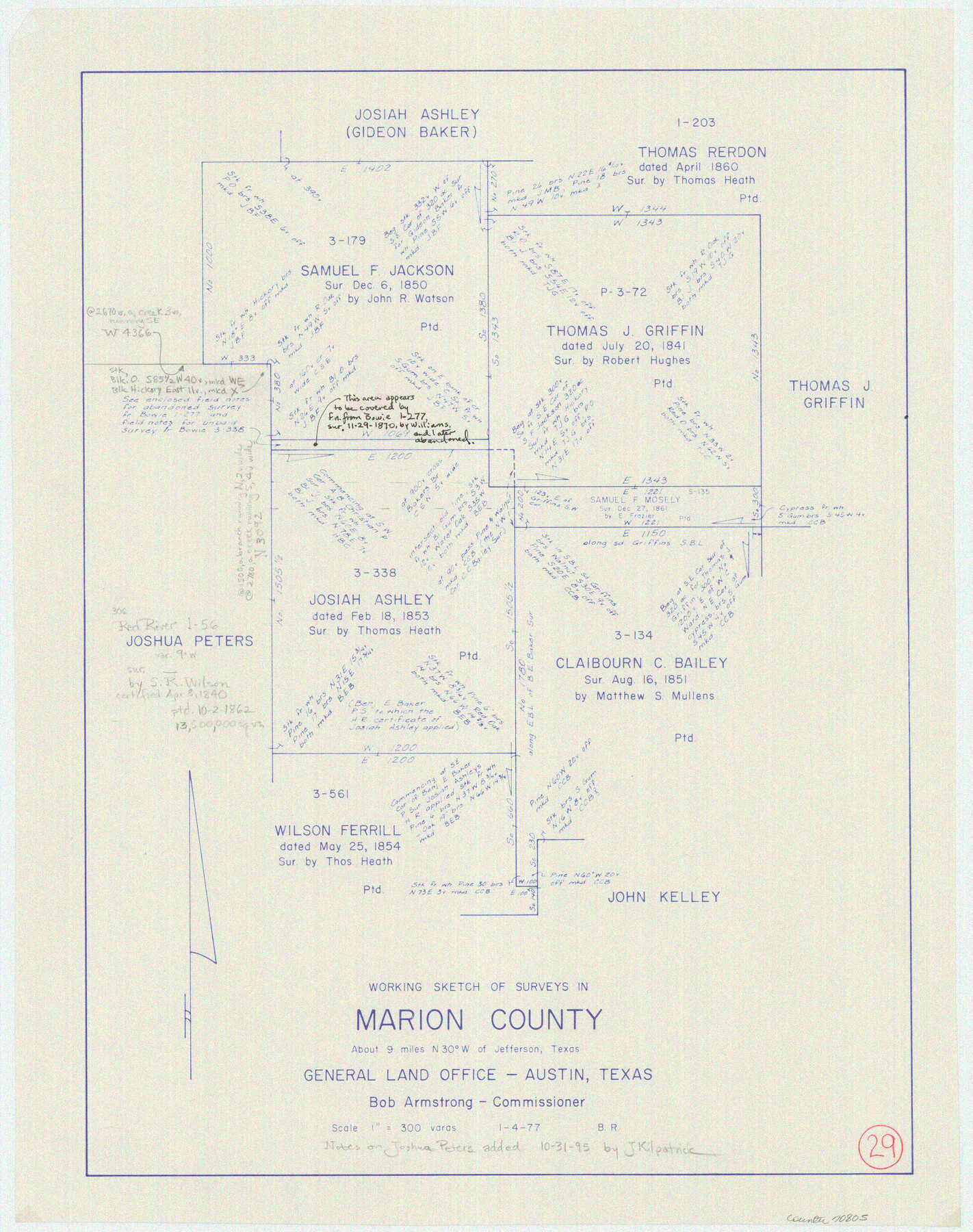
Marion County Working Sketch 29
-
Map/Doc
70805
-
Collection
General Map Collection
-
Object Dates
1/4/1977 (Creation Date)
10/31/1995 (Revision Date)
-
People and Organizations
Beverly Robison (Draftsman)
Joan Kilpatrick (Draftsman)
-
Counties
Marion
-
Subjects
Surveying Working Sketch
-
Height x Width
20.4 x 16.1 inches
51.8 x 40.9 cm
-
Scale
1" = 300 varas
Part of: General Map Collection
Hale County Rolled Sketch 10

Print $40.00
- Digital $50.00
Hale County Rolled Sketch 10
Size 52.4 x 28.3 inches
Map/Doc 76447
Kimble County Working Sketch 74

Print $20.00
- Digital $50.00
Kimble County Working Sketch 74
1966
Size 43.1 x 34.2 inches
Map/Doc 70142
[Sketch for Mineral Application 14125 - Neches River, R. B. Moore]
![65667, [Sketch for Mineral Application 14125 - Neches River, R. B. Moore], General Map Collection](https://historictexasmaps.com/wmedia_w700/maps/65667.tif.jpg)
Print $40.00
- Digital $50.00
[Sketch for Mineral Application 14125 - Neches River, R. B. Moore]
1928
Size 26.1 x 50.0 inches
Map/Doc 65667
Travis County Sketch File 43

Print $30.00
- Digital $50.00
Travis County Sketch File 43
1887
Size 8.8 x 9.3 inches
Map/Doc 38359
Flight Mission No. BRE-5P, Frame 192, Nueces County

Print $20.00
- Digital $50.00
Flight Mission No. BRE-5P, Frame 192, Nueces County
1956
Size 18.4 x 22.3 inches
Map/Doc 86838
Castro County Sketch File 4c

Print $4.00
- Digital $50.00
Castro County Sketch File 4c
Size 12.7 x 8.8 inches
Map/Doc 17469
[Sketch for Mineral Application 36425 - Jefferson County, Ley C. Moore]
![65616, [Sketch for Mineral Application 36425 - Jefferson County, Ley C. Moore], General Map Collection](https://historictexasmaps.com/wmedia_w700/maps/65616.tif.jpg)
Print $40.00
- Digital $50.00
[Sketch for Mineral Application 36425 - Jefferson County, Ley C. Moore]
1942
Size 49.2 x 35.0 inches
Map/Doc 65616
[Sketch for Mineral Application 26543 - Sabine River, D. H. Sanford]
![65677, [Sketch for Mineral Application 26543 - Sabine River, D. H. Sanford], General Map Collection](https://historictexasmaps.com/wmedia_w700/maps/65677.tif.jpg)
Print $40.00
- Digital $50.00
[Sketch for Mineral Application 26543 - Sabine River, D. H. Sanford]
1931
Size 30.8 x 71.9 inches
Map/Doc 65677
Kimble County Working Sketch 51

Print $20.00
- Digital $50.00
Kimble County Working Sketch 51
1953
Size 36.3 x 40.1 inches
Map/Doc 70119
Jasper County Sketch File 21

Print $4.00
- Digital $50.00
Jasper County Sketch File 21
Size 13.4 x 8.9 inches
Map/Doc 27820
Flight Mission No. DQN-5K, Frame 78, Calhoun County

Print $20.00
- Digital $50.00
Flight Mission No. DQN-5K, Frame 78, Calhoun County
1953
Size 18.6 x 22.3 inches
Map/Doc 84411
Flight Mission No. CRC-3R, Frame 97, Chambers County

Print $20.00
- Digital $50.00
Flight Mission No. CRC-3R, Frame 97, Chambers County
1956
Size 18.5 x 22.3 inches
Map/Doc 84835
You may also like
Terrell County Rolled Sketch 56

Print $20.00
- Digital $50.00
Terrell County Rolled Sketch 56
1986
Size 36.6 x 42.0 inches
Map/Doc 9992
[W. C. RR. Co. Blks. 1 & 2, I. & G. N. RR. Co. Blk. 1, in southeast part of County]
![90487, [W. C. RR. Co. Blks. 1 & 2, I. & G. N. RR. Co. Blk. 1, in southeast part of County], Twichell Survey Records](https://historictexasmaps.com/wmedia_w700/maps/90487-1.tif.jpg)
Print $2.00
- Digital $50.00
[W. C. RR. Co. Blks. 1 & 2, I. & G. N. RR. Co. Blk. 1, in southeast part of County]
1879
Size 6.5 x 5.8 inches
Map/Doc 90487
Randall County Boundary File 2

Print $14.00
- Digital $50.00
Randall County Boundary File 2
Size 8.9 x 7.9 inches
Map/Doc 58111
Wichita County Sketch File 28

Print $22.00
- Digital $50.00
Wichita County Sketch File 28
1929
Size 12.5 x 17.0 inches
Map/Doc 40130
Real County Rolled Sketch 18

Print $20.00
- Digital $50.00
Real County Rolled Sketch 18
Size 18.5 x 24.3 inches
Map/Doc 7462
Burnet County Sketch File 30

Print $4.00
- Digital $50.00
Burnet County Sketch File 30
Size 11.0 x 8.0 inches
Map/Doc 16746
Jeff Davis County Sketch File 44

Print $8.00
- Digital $50.00
Jeff Davis County Sketch File 44
1886
Size 8.5 x 8.0 inches
Map/Doc 28071
Angelina County Working Sketch 9

Print $20.00
- Digital $50.00
Angelina County Working Sketch 9
1924
Size 28.5 x 28.5 inches
Map/Doc 67090
[Sketch of part of Blks. 4, B5, 6, 2Z, M6, M8, and M13]
![89645, [Sketch of part of Blks. 4, B5, 6, 2Z, M6, M8, and M13], Twichell Survey Records](https://historictexasmaps.com/wmedia_w700/maps/89645-1.tif.jpg)
Print $40.00
- Digital $50.00
[Sketch of part of Blks. 4, B5, 6, 2Z, M6, M8, and M13]
Size 22.7 x 55.3 inches
Map/Doc 89645
Medina County Working Sketch 19

Print $20.00
- Digital $50.00
Medina County Working Sketch 19
1980
Size 19.4 x 29.1 inches
Map/Doc 70934

Shackelford County Working Sketch 11

Print $20.00
- Digital $50.00
Shackelford County Working Sketch 11
1993
Size 16.2 x 37.8 inches
Map/Doc 63851