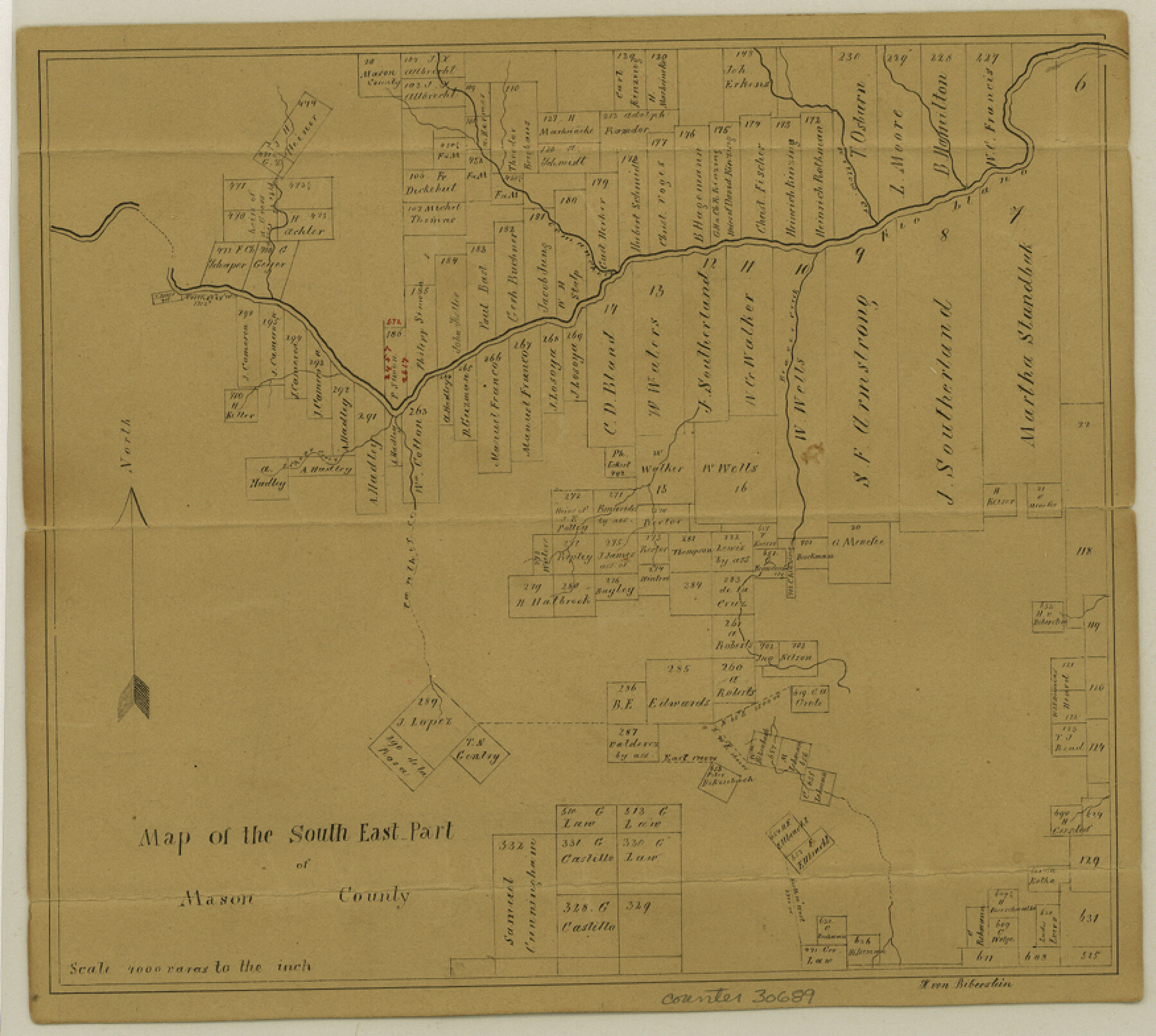
Mason County Sketch File 7
Map of the South East Part of Mason County
-
Map/Doc
30689
-
Collection
General Map Collection
-
People and Organizations
H.R. von Biberstein (Surveyor/Engineer)
-
Counties
Mason Gillespie
-
Subjects
Surveying Sketch File
-
Height x Width
7.9 x 8.8 inches
20.1 x 22.4 cm
-
Medium
paper, manuscript
-
Scale
1" = 4000 varas
-
Features
Rio Llano
Comanche Creek
Turner Creek
Panther Creek
Beaver Creek
Part of: General Map Collection
Wichita County Sketch File 3

Print $8.00
- Digital $50.00
Wichita County Sketch File 3
1856
Size 7.2 x 16.3 inches
Map/Doc 40033
[Texas & Pacific Railway, Longview to Dallas]
![64097, [Texas & Pacific Railway, Longview to Dallas], General Map Collection](https://historictexasmaps.com/wmedia_w700/maps/64097.tif.jpg)
Print $40.00
- Digital $50.00
[Texas & Pacific Railway, Longview to Dallas]
1873
Size 15.5 x 124.0 inches
Map/Doc 64097
Anderson County Rolled Sketch 12

Print $20.00
- Digital $50.00
Anderson County Rolled Sketch 12
1954
Size 24.6 x 21.3 inches
Map/Doc 77157
Flight Mission No. BRA-7M, Frame 35, Jefferson County

Print $20.00
- Digital $50.00
Flight Mission No. BRA-7M, Frame 35, Jefferson County
1953
Size 18.7 x 22.4 inches
Map/Doc 85486
Clay County Boundary File 9

Print $8.00
- Digital $50.00
Clay County Boundary File 9
Size 7.7 x 8.2 inches
Map/Doc 51393
Pecos County Working Sketch 126

Print $40.00
- Digital $50.00
Pecos County Working Sketch 126
1974
Size 83.6 x 38.2 inches
Map/Doc 71599

University Lands Blocks 29-33, Crockett County, Texas

Print $20.00
- Digital $50.00
University Lands Blocks 29-33, Crockett County, Texas
1936
Size 29.2 x 42.4 inches
Map/Doc 2407
Map of Asylum Lands

Print $20.00
- Digital $50.00
Map of Asylum Lands
1857
Size 28.4 x 18.5 inches
Map/Doc 2459
Reeves County Rolled Sketch 1

Print $40.00
- Digital $50.00
Reeves County Rolled Sketch 1
Size 52.9 x 38.5 inches
Map/Doc 9844
Prison Property, Walker Co.

Print $20.00
- Digital $50.00
Prison Property, Walker Co.
Size 19.3 x 20.2 inches
Map/Doc 94278
Matagorda County Working Sketch 21

Print $20.00
- Digital $50.00
Matagorda County Working Sketch 21
1966
Size 35.5 x 41.2 inches
Map/Doc 70879
You may also like
Reagan County Boundary File 2

Print $20.00
- Digital $50.00
Reagan County Boundary File 2
Size 17.5 x 32.4 inches
Map/Doc 58190
Flight Mission No. BRA-16M, Frame 57, Jefferson County

Print $20.00
- Digital $50.00
Flight Mission No. BRA-16M, Frame 57, Jefferson County
1953
Size 18.3 x 22.5 inches
Map/Doc 85674
Jefferson County Rolled Sketch 25

Print $20.00
- Digital $50.00
Jefferson County Rolled Sketch 25
1939
Size 43.4 x 36.0 inches
Map/Doc 9290
Gregg County Rolled Sketch FB

Print $84.00
- Digital $50.00
Gregg County Rolled Sketch FB
1932
Size 25.2 x 56.7 inches
Map/Doc 9326
Foard County Aerial Photograph Index Sheet 3

Print $20.00
- Digital $50.00
Foard County Aerial Photograph Index Sheet 3
1950
Size 20.3 x 18.9 inches
Map/Doc 83690
Hill County Sketch File 24

Print $40.00
- Digital $50.00
Hill County Sketch File 24
Size 15.6 x 13.8 inches
Map/Doc 26516
Starr County Sketch File 39

Print $20.00
- Digital $50.00
Starr County Sketch File 39
1940
Size 22.9 x 22.1 inches
Map/Doc 12339
Flight Mission No. CGI-4N, Frame 184, Cameron County

Print $20.00
- Digital $50.00
Flight Mission No. CGI-4N, Frame 184, Cameron County
1955
Size 18.7 x 22.3 inches
Map/Doc 84687
Cherokee County Sketch File 10

Print $4.00
- Digital $50.00
Cherokee County Sketch File 10
1847
Size 8.2 x 9.5 inches
Map/Doc 18136
Flight Mission No. BQY-15M, Frame 21, Harris County

Print $20.00
- Digital $50.00
Flight Mission No. BQY-15M, Frame 21, Harris County
1953
Size 18.7 x 22.3 inches
Map/Doc 85319

Shelby County Rolled Sketch 15

Print $40.00
- Digital $50.00
Shelby County Rolled Sketch 15
1948
Size 22.5 x 53.9 inches
Map/Doc 9924