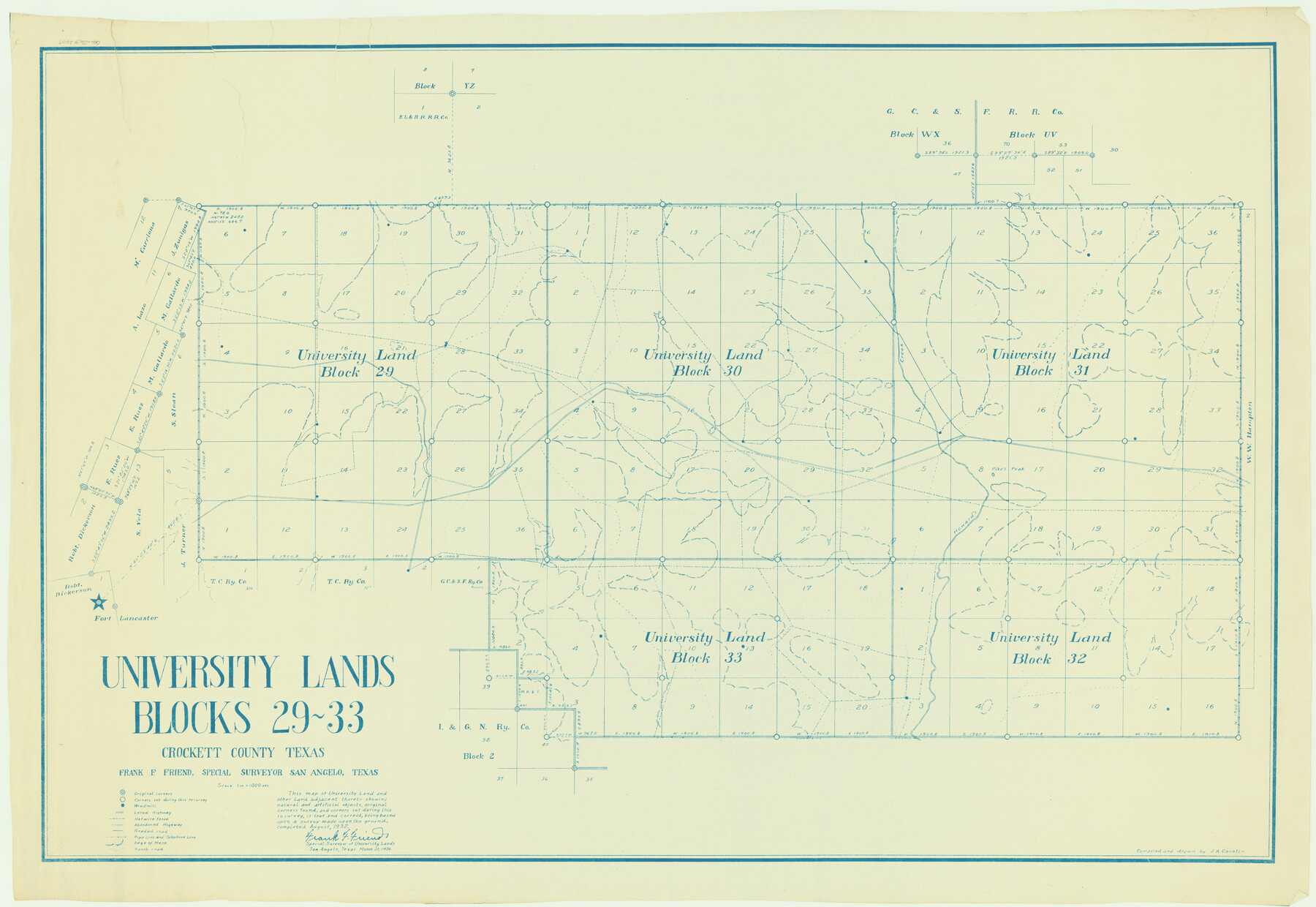
University Lands Blocks 29-33, Crockett County, Texas
Blocks 29 through 33 in Crockett County.
K-8-103; K-8-203b; K-8-203d
-
Map/Doc
2407
-
Collection
General Map Collection
-
Object Dates
1936 (Creation Date)
-
People and Organizations
Frank F. Friend (Surveyor/Engineer)
-
Counties
Crockett
-
Height x Width
29.2 x 42.4 inches
74.2 x 107.7 cm
Part of: General Map Collection
Amistad International Reservoir on Rio Grande 70a

Print $20.00
- Digital $50.00
Amistad International Reservoir on Rio Grande 70a
1949
Size 28.5 x 39.5 inches
Map/Doc 73357
Harris County Rolled Sketch 80

Print $20.00
- Digital $50.00
Harris County Rolled Sketch 80
1958
Size 31.1 x 31.0 inches
Map/Doc 6116
Hartley County Sketch File 15

Print $20.00
- Digital $50.00
Hartley County Sketch File 15
Size 31.2 x 16.6 inches
Map/Doc 11737
Leon County Working Sketch 9

Print $20.00
- Digital $50.00
Leon County Working Sketch 9
1949
Size 16.7 x 18.1 inches
Map/Doc 70408
Map of Coleman County

Print $20.00
- Digital $50.00
Map of Coleman County
1895
Size 26.1 x 18.9 inches
Map/Doc 3415
Map of Marion County

Print $20.00
- Digital $50.00
Map of Marion County
1920
Size 29.6 x 42.7 inches
Map/Doc 66917
Galveston County Rolled Sketch 28

Print $347.00
- Digital $50.00
Galveston County Rolled Sketch 28
Size 22.6 x 18.1 inches
Map/Doc 6068
Flight Mission No. DAG-24K, Frame 132, Matagorda County

Print $20.00
- Digital $50.00
Flight Mission No. DAG-24K, Frame 132, Matagorda County
1953
Size 15.8 x 15.8 inches
Map/Doc 86550
Wheeler County Working Sketch 9

Print $40.00
- Digital $50.00
Wheeler County Working Sketch 9
1973
Size 77.6 x 32.1 inches
Map/Doc 72498
Jefferson County Working Sketch 41

Print $20.00
- Digital $50.00
Jefferson County Working Sketch 41
1985
Size 26.4 x 20.8 inches
Map/Doc 66585
[Oceani occidentalis seu terrae novae tabula]
![95835, [Oceani occidentalis seu Terre Noue Tabula Christophorus Columbus], General Map Collection](https://historictexasmaps.com/wmedia_w700/maps/95835-1.tif.jpg)
Print $20.00
- Digital $50.00
[Oceani occidentalis seu terrae novae tabula]
1535
Size 16.0 x 21.6 inches
Map/Doc 95835
Lampasas County Boundary File 2

Print $4.00
- Digital $50.00
Lampasas County Boundary File 2
Size 13.8 x 8.8 inches
Map/Doc 56095
You may also like
[Reynolds Cattle Company Lands]
![90680, [Reynolds Cattle Company Lands], Twichell Survey Records](https://historictexasmaps.com/wmedia_w700/maps/90680-1.tif.jpg)
Print $20.00
- Digital $50.00
[Reynolds Cattle Company Lands]
1908
Size 12.6 x 30.7 inches
Map/Doc 90680
San Augustine County Sketch File 22

Print $4.00
San Augustine County Sketch File 22
Size 12.8 x 8.4 inches
Map/Doc 35687
Roberts County

Print $20.00
- Digital $50.00
Roberts County
1889
Size 20.8 x 19.8 inches
Map/Doc 3993
South Part Brewster Co.

Print $40.00
- Digital $50.00
South Part Brewster Co.
1915
Size 50.0 x 35.2 inches
Map/Doc 89723
General Highway Map, Kendall County, Texas

Print $20.00
General Highway Map, Kendall County, Texas
1961
Size 18.3 x 24.6 inches
Map/Doc 79549
Calhoun County Rolled Sketch 18

Print $20.00
- Digital $50.00
Calhoun County Rolled Sketch 18
1952
Size 12.2 x 11.9 inches
Map/Doc 5371
General Highway Map, Dallas County, Rockwall County, Texas

Print $20.00
General Highway Map, Dallas County, Rockwall County, Texas
1961
Size 18.4 x 24.5 inches
Map/Doc 79430
North Sulphur River, Sims Crossing Sheet

Print $20.00
- Digital $50.00
North Sulphur River, Sims Crossing Sheet
1924
Size 23.4 x 39.9 inches
Map/Doc 65167
Starr County Sketch File 36

Print $26.00
- Digital $50.00
Starr County Sketch File 36
1939
Size 14.3 x 8.7 inches
Map/Doc 36977
Culberson County Sketch File 37

Print $20.00
- Digital $50.00
Culberson County Sketch File 37
1961
Size 24.8 x 18.5 inches
Map/Doc 11273
Dallas County Boundary File 6c

Print $4.00
- Digital $50.00
Dallas County Boundary File 6c
Size 14.0 x 8.6 inches
Map/Doc 52227
Bowie County Sketch File A

Print $40.00
- Digital $50.00
Bowie County Sketch File A
1902
Size 15.6 x 27.3 inches
Map/Doc 10946