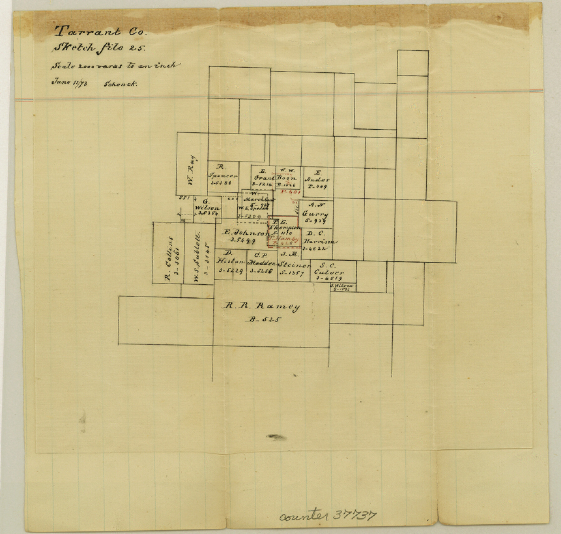
Tarrant County Sketch File 25
[Office sketch of surveys east of Fort Worth]
-
Map/Doc
37737
-
Collection
General Map Collection
-
Object Dates
6/11/1873 (Creation Date)
-
Counties
Tarrant
-
Subjects
Surveying Sketch File
-
Height x Width
8.2 x 8.6 inches
20.8 x 21.8 cm
-
Medium
paper, manuscript
-
Scale
1" = 2000 varas
Part of: General Map Collection
Orange County Working Sketch 2

Print $20.00
- Digital $50.00
Orange County Working Sketch 2
1917
Size 12.8 x 13.1 inches
Map/Doc 71334
Armstrong County Sketch File A-5

Print $40.00
- Digital $50.00
Armstrong County Sketch File A-5
1918
Size 18.0 x 28.2 inches
Map/Doc 10846
Chambers County Rolled Sketch 34

Print $40.00
- Digital $50.00
Chambers County Rolled Sketch 34
1956
Size 50.0 x 85.8 inches
Map/Doc 73571
[Map showing resurvey of Capitol Leagues in Hartley & Dallam Counties, Texas]
![1753, [Map showing resurvey of Capitol Leagues in Hartley & Dallam Counties, Texas], General Map Collection](https://historictexasmaps.com/wmedia_w700/maps/1753-1.tif.jpg)
Print $40.00
- Digital $50.00
[Map showing resurvey of Capitol Leagues in Hartley & Dallam Counties, Texas]
1918
Size 66.9 x 31.0 inches
Map/Doc 1753
Flight Mission No. BRA-3M, Frame 199, Jefferson County

Print $20.00
- Digital $50.00
Flight Mission No. BRA-3M, Frame 199, Jefferson County
1953
Size 18.6 x 22.3 inches
Map/Doc 85414
Jasper County Working Sketch 28

Print $20.00
- Digital $50.00
Jasper County Working Sketch 28
1955
Size 22.6 x 15.6 inches
Map/Doc 66490
Galveston County NRC Article 33.136 Sketch 63

Print $42.00
- Digital $50.00
Galveston County NRC Article 33.136 Sketch 63
2010
Size 36.0 x 24.0 inches
Map/Doc 95003
[F. W. & D. C. Ry. Co. Alignment and Right of Way Map, Clay County]
![64731, [F. W. & D. C. Ry. Co. Alignment and Right of Way Map, Clay County], General Map Collection](https://historictexasmaps.com/wmedia_w700/maps/64731-1.tif.jpg)
Print $20.00
- Digital $50.00
[F. W. & D. C. Ry. Co. Alignment and Right of Way Map, Clay County]
1927
Size 18.7 x 11.8 inches
Map/Doc 64731
Andrews County Working Sketch 4

Print $20.00
- Digital $50.00
Andrews County Working Sketch 4
1954
Size 42.8 x 19.2 inches
Map/Doc 67050
Erath County Sketch File 35

Print $8.00
- Digital $50.00
Erath County Sketch File 35
1992
Size 14.5 x 8.8 inches
Map/Doc 22326
Brazoria County Sketch File 31

Print $40.00
- Digital $50.00
Brazoria County Sketch File 31
1894
Size 17.4 x 14.4 inches
Map/Doc 15039
Flight Mission No. BRE-1P, Frame 140, Nueces County

Print $20.00
- Digital $50.00
Flight Mission No. BRE-1P, Frame 140, Nueces County
1956
Size 18.8 x 22.7 inches
Map/Doc 86700
You may also like
Mapa del Presidio de San Antonio de Bexar, i sus Misiones de la Provinsia de Texas

Print $20.00
Mapa del Presidio de San Antonio de Bexar, i sus Misiones de la Provinsia de Texas
1764
Size 14.5 x 18.4 inches
Map/Doc 94455
G.C. & S.F. Ry. Main Line, Texas, Right of Way Map, Keeler to Haslet

Print $40.00
- Digital $50.00
G.C. & S.F. Ry. Main Line, Texas, Right of Way Map, Keeler to Haslet
1916
Size 25.3 x 103.5 inches
Map/Doc 64546
Morris County Rolled Sketch 2A

Print $20.00
- Digital $50.00
Morris County Rolled Sketch 2A
Size 22.5 x 17.6 inches
Map/Doc 10230
Robertson County Rolled Sketch 1A

Print $20.00
- Digital $50.00
Robertson County Rolled Sketch 1A
1966
Size 45.3 x 28.1 inches
Map/Doc 9863
Louisiana and Texas Intracoastal Waterway

Print $20.00
- Digital $50.00
Louisiana and Texas Intracoastal Waterway
1929
Size 13.6 x 19.6 inches
Map/Doc 83342
Donley County Working Sketch 8

Print $20.00
- Digital $50.00
Donley County Working Sketch 8
1981
Size 36.9 x 46.8 inches
Map/Doc 68741
Calcasieu Pass to Sabine Pass

Print $20.00
- Digital $50.00
Calcasieu Pass to Sabine Pass
1925
Size 44.1 x 36.0 inches
Map/Doc 69804
Intracoastal Waterway in Texas - Corpus Christi to Point Isabel including Arroyo Colorado to Mo. Pac. R.R. Bridge Near Harlingen

Print $20.00
- Digital $50.00
Intracoastal Waterway in Texas - Corpus Christi to Point Isabel including Arroyo Colorado to Mo. Pac. R.R. Bridge Near Harlingen
1933
Size 28.2 x 41.0 inches
Map/Doc 61853
Midland County Sketch File 13

Print $4.00
- Digital $50.00
Midland County Sketch File 13
1940
Size 11.2 x 8.7 inches
Map/Doc 31576
[Sections 302-313 and sections south of Blocks D and AX]
![92017, [Sections 302-313 and sections south of Blocks D and AX], Twichell Survey Records](https://historictexasmaps.com/wmedia_w700/maps/92017-1.tif.jpg)
Print $20.00
- Digital $50.00
[Sections 302-313 and sections south of Blocks D and AX]
Size 17.5 x 35.6 inches
Map/Doc 92017
Potter County Sketch File 16

Print $38.00
- Digital $50.00
Potter County Sketch File 16
Size 13.0 x 13.9 inches
Map/Doc 34401
Flight Mission No. DIX-3P, Frame 134, Aransas County

Print $20.00
- Digital $50.00
Flight Mission No. DIX-3P, Frame 134, Aransas County
1956
Size 17.8 x 19.0 inches
Map/Doc 83764