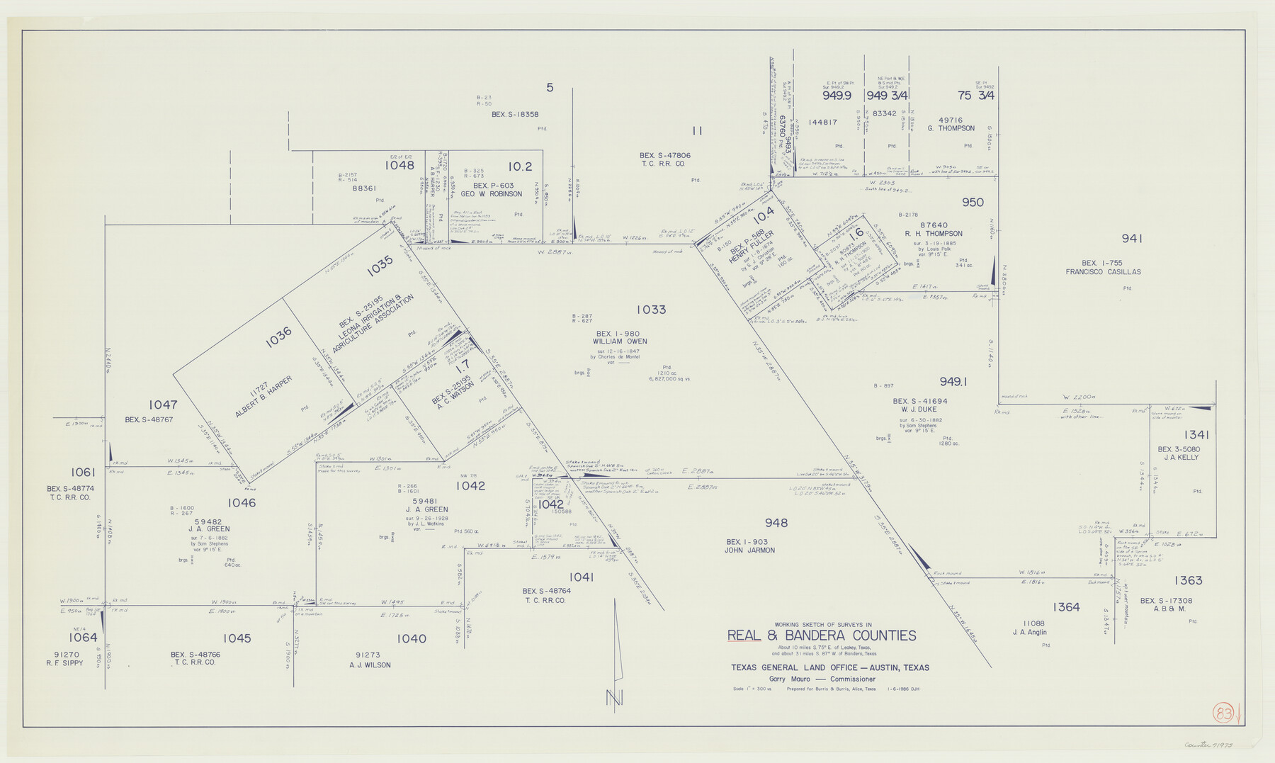
Real County Working Sketch 83
-
Map/Doc
71975
-
Collection
General Map Collection
-
Object Dates
1/6/1986 (Creation Date)
-
People and Organizations
Douglas Howard (Draftsman)
-
Counties
Real Bandera
-
Subjects
Surveying Working Sketch
-
Height x Width
25.7 x 43.0 inches
65.3 x 109.2 cm
-
Scale
1" = 300 varas
Part of: General Map Collection
Bee County Sketch File 6

Print $6.00
- Digital $50.00
Bee County Sketch File 6
1860
Size 12.3 x 7.7 inches
Map/Doc 14272
Tom Green County Rolled Sketch 5

Print $20.00
- Digital $50.00
Tom Green County Rolled Sketch 5
1947
Size 44.9 x 35.0 inches
Map/Doc 9997
Cooke County Working Sketch 16

Print $20.00
- Digital $50.00
Cooke County Working Sketch 16
1949
Size 29.8 x 28.9 inches
Map/Doc 68253
[San Antonio & Aransas Pass]
![64208, [San Antonio & Aransas Pass], General Map Collection](https://historictexasmaps.com/wmedia_w700/maps/64208.tif.jpg)
Print $40.00
- Digital $50.00
[San Antonio & Aransas Pass]
Size 17.0 x 50.7 inches
Map/Doc 64208
Flight Mission No. BRA-3M, Frame 191, Jefferson County

Print $20.00
- Digital $50.00
Flight Mission No. BRA-3M, Frame 191, Jefferson County
1953
Size 18.6 x 22.3 inches
Map/Doc 85406
Hardin County Sketch File 66

Print $20.00
- Digital $50.00
Hardin County Sketch File 66
1948
Size 19.5 x 35.8 inches
Map/Doc 11639
Greer County Sketch File 2

Print $20.00
- Digital $50.00
Greer County Sketch File 2
1883
Size 25.4 x 19.9 inches
Map/Doc 11582
Flight Mission No. BRE-2P, Frame 48, Nueces County

Print $20.00
- Digital $50.00
Flight Mission No. BRE-2P, Frame 48, Nueces County
1956
Size 18.5 x 22.3 inches
Map/Doc 86750
Val Verde County Rolled Sketch 69A

Print $40.00
- Digital $50.00
Val Verde County Rolled Sketch 69A
1942
Size 11.0 x 139.1 inches
Map/Doc 10086

Schleicher County Sketch File 27

Print $20.00
- Digital $50.00
Schleicher County Sketch File 27
Size 23.0 x 19.2 inches
Map/Doc 12305

You may also like
[Sketch for Mineral Application 16700 - Pecos River Bed]
![2808, [Sketch for Mineral Application 16700 - Pecos River Bed], General Map Collection](https://historictexasmaps.com/wmedia_w700/maps/2808.tif.jpg)
Print $20.00
- Digital $50.00
[Sketch for Mineral Application 16700 - Pecos River Bed]
1927
Size 19.9 x 30.9 inches
Map/Doc 2808
Concho County Working Sketch 24

Print $20.00
- Digital $50.00
Concho County Working Sketch 24
1981
Size 35.0 x 44.2 inches
Map/Doc 68206
San Saba County Boundary File 77

Print $32.00
- Digital $50.00
San Saba County Boundary File 77
Size 9.2 x 7.7 inches
Map/Doc 58577
Bexar County Sketch File 1a

Print $24.00
- Digital $50.00
Bexar County Sketch File 1a
1847
Size 12.7 x 8.2 inches
Map/Doc 14468
Refugio County Boundary File 1 (3)

Print $22.00
- Digital $50.00
Refugio County Boundary File 1 (3)
Size 10.4 x 27.5 inches
Map/Doc 58231
Schleicher County Working Sketch 25

Print $20.00
- Digital $50.00
Schleicher County Working Sketch 25
1958
Size 29.2 x 13.2 inches
Map/Doc 63827
Crockett County Sketch File 8 (1)

Print $6.00
- Digital $50.00
Crockett County Sketch File 8 (1)
1858
Size 9.8 x 4.6 inches
Map/Doc 19652
Crockett County Working Sketch 62

Print $40.00
- Digital $50.00
Crockett County Working Sketch 62
1956
Size 35.4 x 66.1 inches
Map/Doc 63760
Blanco County Working Sketch 32

Print $20.00
- Digital $50.00
Blanco County Working Sketch 32
1972
Size 31.8 x 32.2 inches
Map/Doc 67392
Wichita County Sketch File 16

Print $4.00
- Digital $50.00
Wichita County Sketch File 16
1890
Size 12.9 x 8.9 inches
Map/Doc 40095
Erath County Sketch File A2

Print $20.00
- Digital $50.00
Erath County Sketch File A2
Size 15.9 x 19.5 inches
Map/Doc 11464
Upshur County Sketch File 15

Print $20.00
- Digital $50.00
Upshur County Sketch File 15
1934
Size 20.7 x 31.2 inches
Map/Doc 12505