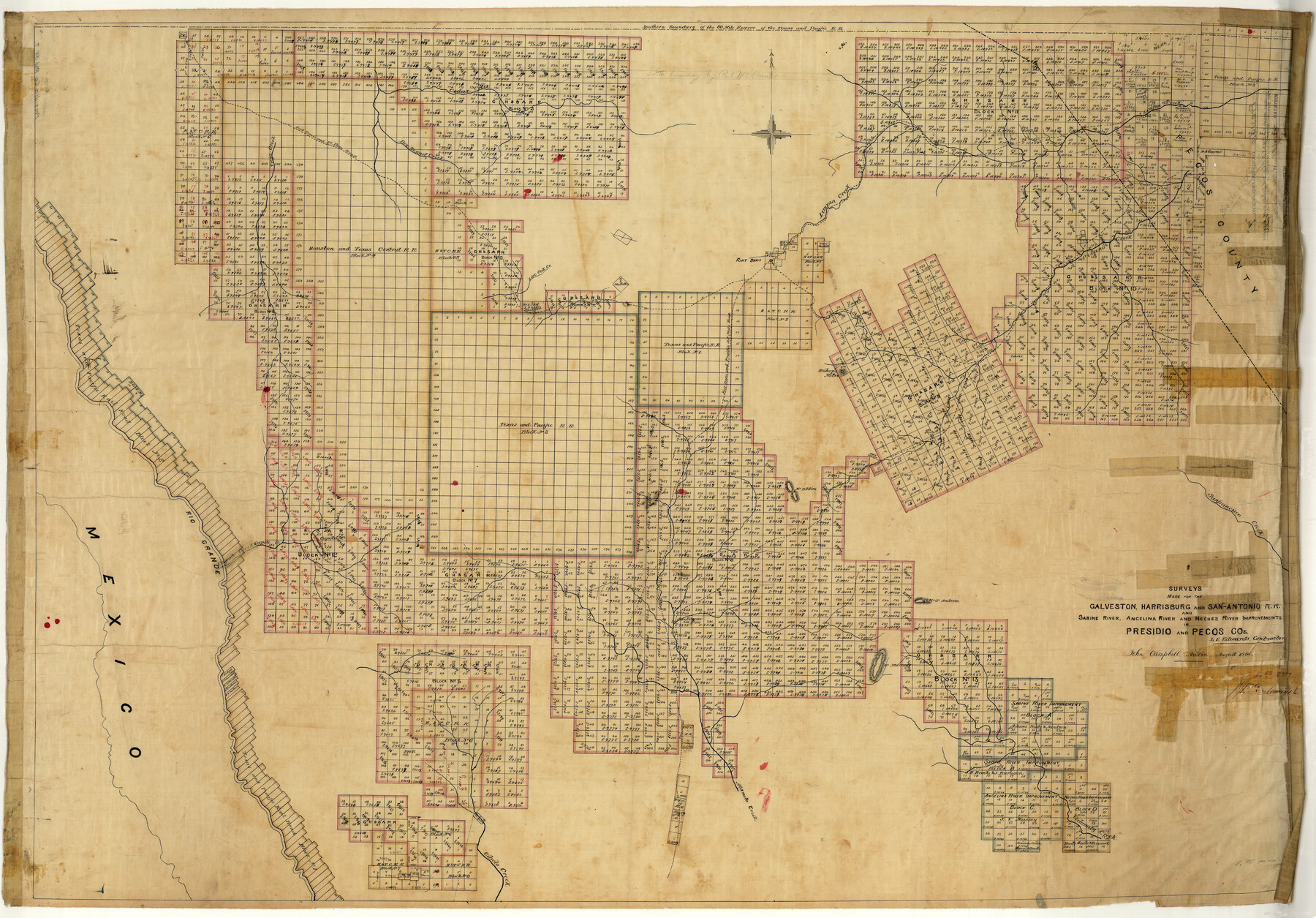
Presidio County Rolled Sketch 7
Surveys made for the Galveston, Harrisburg and San Antonio R.R. and Sabine River, Angelina River and Neches River Improvements in Presidio and Pecos Co's.
-
Map/Doc
9762
-
Collection
General Map Collection
-
Object Dates
1875 (Creation Date)
-
People and Organizations
John Campbell (Surveyor/Engineer)
-
Counties
Presidio
-
Subjects
Surveying Rolled Sketch
-
Height x Width
37.5 x 53.8 inches
95.3 x 136.7 cm
-
Medium
linen, manuscript
Part of: General Map Collection
Childress County Sketch File 15a

Print $4.00
- Digital $50.00
Childress County Sketch File 15a
Size 8.6 x 11.7 inches
Map/Doc 18303
Winkler County

Print $20.00
- Digital $50.00
Winkler County
1932
Size 40.3 x 40.1 inches
Map/Doc 77462
Maverick County Working Sketch 8

Print $40.00
- Digital $50.00
Maverick County Working Sketch 8
1959
Size 50.3 x 37.7 inches
Map/Doc 70900
Presidio County Working Sketch 31

Print $20.00
- Digital $50.00
Presidio County Working Sketch 31
1946
Size 25.2 x 26.3 inches
Map/Doc 71708
A Topographical Map of the Government Tract Adjoining the City of Austin

Print $20.00
- Digital $50.00
A Topographical Map of the Government Tract Adjoining the City of Austin
1840
Size 40.7 x 36.1 inches
Map/Doc 2177
Surveyors report on resurvey of Capitol Leagues in three parts, also copy of judgement of the District Court, Travis County

Print $20.00
- Digital $50.00
Surveyors report on resurvey of Capitol Leagues in three parts, also copy of judgement of the District Court, Travis County
Size 12.3 x 15.8 inches
Map/Doc 62579
San Jacinto County Boundary File 1a

Print $58.00
- Digital $50.00
San Jacinto County Boundary File 1a
Size 14.5 x 8.9 inches
Map/Doc 58551
Pecos County Working Sketch 111

Print $40.00
- Digital $50.00
Pecos County Working Sketch 111
1972
Size 32.9 x 69.6 inches
Map/Doc 71584
Culberson County Rolled Sketch 32

Print $20.00
- Digital $50.00
Culberson County Rolled Sketch 32
1931
Size 20.2 x 36.4 inches
Map/Doc 5657
Hale County Sketch File D

Print $40.00
- Digital $50.00
Hale County Sketch File D
1901
Size 16.5 x 12.2 inches
Map/Doc 24721
Waller County Working Sketch Graphic Index

Print $20.00
- Digital $50.00
Waller County Working Sketch Graphic Index
1945
Size 46.7 x 27.2 inches
Map/Doc 76730
Val Verde County Boundary File 103

Print $82.00
- Digital $50.00
Val Verde County Boundary File 103
Size 9.1 x 9.1 inches
Map/Doc 59577
You may also like
Hockley County Sketch Mineral Application Number 39180

Print $20.00
- Digital $50.00
Hockley County Sketch Mineral Application Number 39180
1947
Size 16.1 x 20.1 inches
Map/Doc 92246
Bastrop County Working Sketch 8

Print $20.00
- Digital $50.00
Bastrop County Working Sketch 8
1937
Size 23.9 x 43.1 inches
Map/Doc 67308
Reeves County Working Sketch 43

Print $20.00
- Digital $50.00
Reeves County Working Sketch 43
1974
Size 43.2 x 37.1 inches
Map/Doc 63486
Garza County Sketch File G-1

Print $20.00
- Digital $50.00
Garza County Sketch File G-1
1904
Size 20.4 x 20.6 inches
Map/Doc 11554
Coke County Sketch File 31

Print $4.00
- Digital $50.00
Coke County Sketch File 31
Size 14.1 x 8.8 inches
Map/Doc 18643
J.K Gill & Cos Map of Oregon

Print $20.00
- Digital $50.00
J.K Gill & Cos Map of Oregon
1882
Size 29.0 x 32.3 inches
Map/Doc 94055
[Surveying Sketch of John Knight, Champion Choate, A.M. Lejarza, et al in Hardin County, Texas - Exhibit "G"]
![75822, [Surveying Sketch of John Knight, Champion Choate, A.M. Lejarza, et al in Hardin County, Texas - Exhibit "G"], Maddox Collection](https://historictexasmaps.com/wmedia_w700/maps/75822.tif.jpg)
Print $20.00
- Digital $50.00
[Surveying Sketch of John Knight, Champion Choate, A.M. Lejarza, et al in Hardin County, Texas - Exhibit "G"]
Size 18.3 x 23.5 inches
Map/Doc 75822
[Sketch of San Antonio del Encinal, Hidalgo County, Texas]
![4457, [Sketch of San Antonio del Encinal, Hidalgo County, Texas], Maddox Collection](https://historictexasmaps.com/wmedia_w700/maps/4457-1.tif.jpg)
Print $20.00
- Digital $50.00
[Sketch of San Antonio del Encinal, Hidalgo County, Texas]
Size 12.1 x 27.1 inches
Map/Doc 4457
Flight Mission No. DAG-28K, Frame 29, Matagorda County

Print $20.00
- Digital $50.00
Flight Mission No. DAG-28K, Frame 29, Matagorda County
1953
Size 16.2 x 16.1 inches
Map/Doc 86597
Map of the country adjacent to the left bank of the Rio Grande below Matamoros

Print $20.00
- Digital $50.00
Map of the country adjacent to the left bank of the Rio Grande below Matamoros
1847
Size 18.3 x 27.3 inches
Map/Doc 72868
[Capitol Leagues in Lamb County]
![91014, [Capitol Leagues in Lamb County], Twichell Survey Records](https://historictexasmaps.com/wmedia_w700/maps/91014-1.tif.jpg)
Print $2.00
- Digital $50.00
[Capitol Leagues in Lamb County]
1912
Size 12.7 x 8.8 inches
Map/Doc 91014
Tom Green County

Print $40.00
- Digital $50.00
Tom Green County
Size 43.6 x 111.2 inches
Map/Doc 82058