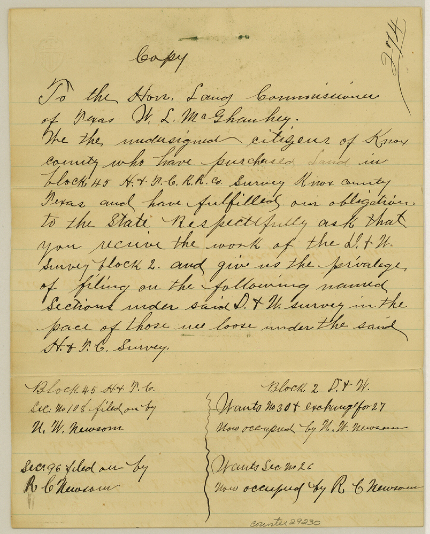
Knox County Sketch File 13
[Application for correction of surveys in Blocks 2 and 45 in southeast corner of the county]
-
Map/Doc
29230
-
Collection
General Map Collection
-
Object Dates
5/2/1892 (Creation Date)
-
People and Organizations
N.W. Newsom (Surveyor/Engineer)
-
Counties
Knox
-
Subjects
Surveying Sketch File
-
Height x Width
10.0 x 8.0 inches
25.4 x 20.3 cm
-
Medium
paper, manuscript
Part of: General Map Collection
Trinity River, Levee Improvement Districts, Widths of Floodways

Print $4.00
- Digital $50.00
Trinity River, Levee Improvement Districts, Widths of Floodways
1919
Size 23.5 x 17.6 inches
Map/Doc 65250
Kimble County Rolled Sketch 15

Print $59.00
- Digital $50.00
Kimble County Rolled Sketch 15
1886
Size 28.3 x 42.1 inches
Map/Doc 6508
Zavala County

Print $40.00
- Digital $50.00
Zavala County
1977
Size 43.6 x 49.3 inches
Map/Doc 95684
Llano County Sketch File 11

Print $10.00
- Digital $50.00
Llano County Sketch File 11
1885
Size 9.5 x 8.5 inches
Map/Doc 30375
Map of Kimble County

Print $20.00
- Digital $50.00
Map of Kimble County
1879
Size 18.7 x 28.9 inches
Map/Doc 3765
Edwards County Working Sketch 102

Print $20.00
- Digital $50.00
Edwards County Working Sketch 102
1971
Size 35.0 x 25.5 inches
Map/Doc 68978
Andrews County Boundary File 2b

Print $217.00
- Digital $50.00
Andrews County Boundary File 2b
Size 9.6 x 56.0 inches
Map/Doc 49698
Flight Mission No. CRC-4R, Frame 162, Chambers County

Print $20.00
- Digital $50.00
Flight Mission No. CRC-4R, Frame 162, Chambers County
1956
Size 18.6 x 22.4 inches
Map/Doc 84921
Gregg County Boundary File 4

Print $14.00
- Digital $50.00
Gregg County Boundary File 4
Size 14.1 x 8.6 inches
Map/Doc 53992
Presidio County Sketch File 84

Print $20.00
- Digital $50.00
Presidio County Sketch File 84
1949
Size 15.2 x 37.2 inches
Map/Doc 11723
Old Miscellaneous File 27c

Print $18.00
- Digital $50.00
Old Miscellaneous File 27c
1880
Size 14.1 x 8.6 inches
Map/Doc 75727
Gregg County Working Sketch 4

Print $20.00
- Digital $50.00
Gregg County Working Sketch 4
1931
Size 29.1 x 32.9 inches
Map/Doc 63270
You may also like
Gillespie County Rolled Sketch 4

Print $20.00
- Digital $50.00
Gillespie County Rolled Sketch 4
1994
Size 23.3 x 27.1 inches
Map/Doc 6011
Outer Continental Shelf Leasing Maps (Texas Offshore Operations)

Print $20.00
- Digital $50.00
Outer Continental Shelf Leasing Maps (Texas Offshore Operations)
Size 12.7 x 15.2 inches
Map/Doc 76169
[Map showing Jno. H. Gibson Block D]
![92001, [Map showing Jno. H. Gibson Block D], Twichell Survey Records](https://historictexasmaps.com/wmedia_w700/maps/92001-1.tif.jpg)
Print $20.00
- Digital $50.00
[Map showing Jno. H. Gibson Block D]
Size 17.9 x 15.0 inches
Map/Doc 92001
Harris County Sketch File 71

Print $5.00
- Digital $50.00
Harris County Sketch File 71
1941
Size 14.4 x 9.0 inches
Map/Doc 25523
The Republic County of Bexar. Spring 1842

Print $20.00
The Republic County of Bexar. Spring 1842
2020
Size 14.7 x 21.7 inches
Map/Doc 96100
Sketch in Lynn, Terry, Gaines & Dawson Counties, Texas

Print $40.00
- Digital $50.00
Sketch in Lynn, Terry, Gaines & Dawson Counties, Texas
1940
Size 52.5 x 32.6 inches
Map/Doc 89685
Garza County Sketch File D

Print $20.00
- Digital $50.00
Garza County Sketch File D
1901
Size 18.4 x 12.2 inches
Map/Doc 11550
Flight Mission No. DCL-6C, Frame 173, Kenedy County

Print $20.00
- Digital $50.00
Flight Mission No. DCL-6C, Frame 173, Kenedy County
1943
Size 18.6 x 22.4 inches
Map/Doc 85985
[Sketch around H. & T. C. Block 34 and PSL Block B19]
![91954, [Sketch around H. & T. C. Block 34 and PSL Block B19], Twichell Survey Records](https://historictexasmaps.com/wmedia_w700/maps/91954-1.tif.jpg)
Print $20.00
- Digital $50.00
[Sketch around H. & T. C. Block 34 and PSL Block B19]
Size 36.9 x 28.8 inches
Map/Doc 91954
Presidio County Sketch File P

Print $8.00
- Digital $50.00
Presidio County Sketch File P
1916
Size 14.4 x 8.8 inches
Map/Doc 34552
Flight Mission No. DIX-8P, Frame 89, Aransas County

Print $20.00
- Digital $50.00
Flight Mission No. DIX-8P, Frame 89, Aransas County
1956
Size 18.7 x 22.4 inches
Map/Doc 83914
Polk County Rolled Sketch 28

Print $20.00
- Digital $50.00
Polk County Rolled Sketch 28
1951
Size 45.4 x 32.0 inches
Map/Doc 9757