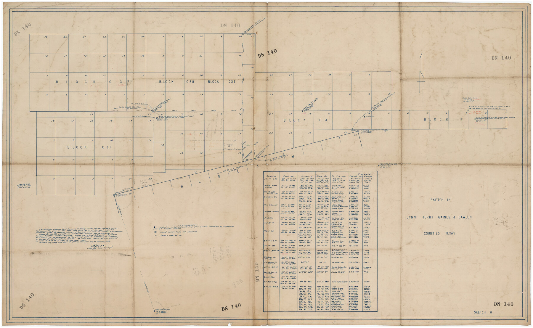
Sketch in Lynn, Terry, Gaines & Dawson Counties, Texas
DN140
-
Map/Doc
89685
-
Collection
Twichell Survey Records
-
Object Dates
10/22/1940 (Creation Date)
-
People and Organizations
W.J. Williams (Surveyor/Engineer)
-
Counties
Lynn Terry Gaines Dawson
-
Height x Width
52.5 x 32.6 inches
133.4 x 82.8 cm
Part of: Twichell Survey Records
Highway Addition to Littlefield, Texas

Print $3.00
- Digital $50.00
Highway Addition to Littlefield, Texas
Size 14.3 x 11.7 inches
Map/Doc 92266
Revised Plat, Section J, Tech Memorial Park, Inc., Infants Garden

Print $20.00
- Digital $50.00
Revised Plat, Section J, Tech Memorial Park, Inc., Infants Garden
1961
Size 29.1 x 33.7 inches
Map/Doc 92786
[Southwest Portion of Glasscock County]
![90765, [Southwest Portion of Glasscock County], Twichell Survey Records](https://historictexasmaps.com/wmedia_w700/maps/90765-1.tif.jpg)
Print $20.00
- Digital $50.00
[Southwest Portion of Glasscock County]
Size 18.7 x 20.9 inches
Map/Doc 90765
[Sketch showing A. B. & M. Block 2]
![91701, [Sketch showing A. B. & M. Block 2], Twichell Survey Records](https://historictexasmaps.com/wmedia_w700/maps/91701-1.tif.jpg)
Print $2.00
- Digital $50.00
[Sketch showing A. B. & M. Block 2]
Size 7.5 x 5.8 inches
Map/Doc 91701
[Working Sketch Showing Southwest Part of the County]
![91117, [Working Sketch Showing Southwest Part of the County], Twichell Survey Records](https://historictexasmaps.com/wmedia_w700/maps/91117-1.tif.jpg)
Print $2.00
- Digital $50.00
[Working Sketch Showing Southwest Part of the County]
1886
Size 14.9 x 9.0 inches
Map/Doc 91117
[Blocks O3 and O4 and Capitol Leagues in the vicinity]
![90391, [Blocks O3 and O4 and Capitol Leagues in the vicinity], Twichell Survey Records](https://historictexasmaps.com/wmedia_w700/maps/90391-1.tif.jpg)
Print $2.00
- Digital $50.00
[Blocks O3 and O4 and Capitol Leagues in the vicinity]
Size 8.4 x 10.5 inches
Map/Doc 90391
Dumas, Moore County, Texas

Print $20.00
- Digital $50.00
Dumas, Moore County, Texas
1891
Size 13.4 x 15.7 inches
Map/Doc 92111
National Parks, Monuments and Shrines of the United States and Canada

National Parks, Monuments and Shrines of the United States and Canada
1958
Size 25.5 x 19.5 inches
Map/Doc 92378
Crane County, Texas

Print $40.00
- Digital $50.00
Crane County, Texas
Size 38.2 x 53.6 inches
Map/Doc 89917
[Block K, Public School Land]
![92907, [Block K, Public School Land], Twichell Survey Records](https://historictexasmaps.com/wmedia_w700/maps/92907-1.tif.jpg)
Print $20.00
- Digital $50.00
[Block K, Public School Land]
1902
Size 17.9 x 32.8 inches
Map/Doc 92907
[East and South lines of County]
![93137, [East and South lines of County], Twichell Survey Records](https://historictexasmaps.com/wmedia_w700/maps/93137-1.tif.jpg)
Print $40.00
- Digital $50.00
[East and South lines of County]
Size 75.7 x 9.0 inches
Map/Doc 93137
Map of Block 1, H. & G. N. RR. Co.

Print $20.00
- Digital $50.00
Map of Block 1, H. & G. N. RR. Co.
1908
Size 26.3 x 32.0 inches
Map/Doc 90899
You may also like
El Paso County Working Sketch 55

Print $20.00
- Digital $50.00
El Paso County Working Sketch 55
1992
Size 44.2 x 36.3 inches
Map/Doc 69077
Marion County Rolled Sketch S

Print $20.00
- Digital $50.00
Marion County Rolled Sketch S
1937
Size 18.8 x 18.1 inches
Map/Doc 6663
Northern Part of Laguna Madre

Print $20.00
- Digital $50.00
Northern Part of Laguna Madre
1946
Size 43.8 x 34.5 inches
Map/Doc 73523
Edwards County Boundary File 27

Print $8.00
- Digital $50.00
Edwards County Boundary File 27
Size 8.8 x 3.9 inches
Map/Doc 52876
Harris County Working Sketch 70

Print $20.00
- Digital $50.00
Harris County Working Sketch 70
1956
Size 25.5 x 32.9 inches
Map/Doc 65962
Laguna Madre, Register No. 1477A

Print $40.00
- Digital $50.00
Laguna Madre, Register No. 1477A
1880
Size 34.3 x 56.0 inches
Map/Doc 73606
[Leagues 27, 28, 69, 70, 71, 72, and 73]
![91096, [Leagues 27, 28, 69, 70, 71, 72, and 73], Twichell Survey Records](https://historictexasmaps.com/wmedia_w700/maps/91096-1.tif.jpg)
Print $20.00
- Digital $50.00
[Leagues 27, 28, 69, 70, 71, 72, and 73]
Size 24.0 x 15.7 inches
Map/Doc 91096
Harris County Historic Topographic 18 1/2

Print $20.00
- Digital $50.00
Harris County Historic Topographic 18 1/2
1916
Size 29.3 x 13.7 inches
Map/Doc 65829
Leon County Rolled Sketch 5

Print $20.00
- Digital $50.00
Leon County Rolled Sketch 5
1947
Size 33.7 x 34.8 inches
Map/Doc 9427
La Salle County Working Sketch 20

Print $20.00
- Digital $50.00
La Salle County Working Sketch 20
1941
Size 23.7 x 29.9 inches
Map/Doc 70321
Hale County Rolled Sketch 6

Print $20.00
- Digital $50.00
Hale County Rolled Sketch 6
1903
Size 35.0 x 28.9 inches
Map/Doc 6045
Dimmit County Sketch File 55

Print $20.00
- Digital $50.00
Dimmit County Sketch File 55
1926
Size 23.1 x 15.7 inches
Map/Doc 11359