Presidio County Sketch File P
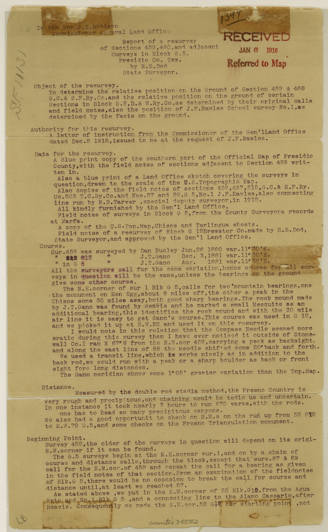
[Report on resurvey of section 459, 460 and adjacent surveys in Block G5]
-
Map/Doc
34552
-
Collection
General Map Collection
-
Object Dates
1/6/1916 (File Date)
1/1916 (Creation Date)
6/26/1880 (Survey Date)
12/3/1881 (Survey Date)
8/1881 (Survey Date)
-
People and Organizations
H.B. Tarver (Surveyor/Engineer)
Dan Bucley (Surveyor/Engineer)
J.T. Gano (Surveyor/Engineer)
D.L. Reavis (Surveyor/Engineer)
R.S. Dod (Surveyor/Engineer)
-
Counties
Presidio
-
Subjects
Surveying Sketch File
-
Height x Width
14.4 x 8.8 inches
36.6 x 22.4 cm
-
Medium
paper, print
-
Comments
See Presidio County Sketch File P1 (34556) and Presidio County Sketch File P2 (34558) for additional reports and correspondence, and see Presidio County Rolled Sketch S (7413), Presidio County Rolled Sketch S1 (7414), and Presidio County Rolled Sketch S2 (7415) for sketches.
-
Features
Chisos Mountains
Hen Egg Mountain
Marfa-Terlingua Road
Mount Fresno
Fresno Canyon
Trail out of Fresno Canyon
Mexican Canyon
Related maps
Presidio County Sketch File P1

Print $4.00
- Digital $50.00
Presidio County Sketch File P1
Size 11.2 x 8.8 inches
Map/Doc 34556
Presidio County Sketch File P2

Print $6.00
- Digital $50.00
Presidio County Sketch File P2
Size 14.3 x 8.9 inches
Map/Doc 34558
Presidio County Rolled Sketch S

Print $20.00
- Digital $50.00
Presidio County Rolled Sketch S
1915
Size 15.6 x 15.4 inches
Map/Doc 7413
Presidio County Rolled Sketch S1

Print $20.00
- Digital $50.00
Presidio County Rolled Sketch S1
Size 13.3 x 18.8 inches
Map/Doc 7414
Presidio County Rolled Sketch S2

Print $20.00
- Digital $50.00
Presidio County Rolled Sketch S2
1916
Size 14.2 x 12.0 inches
Map/Doc 7415
Part of: General Map Collection
Hutchinson County Sketch File 10

Print $40.00
- Digital $50.00
Hutchinson County Sketch File 10
Size 55.8 x 9.2 inches
Map/Doc 10500
Bien & Sterner's New Rail Road Map of the United States and the Canadas compiled from the latest surveys & locations under the direction of Zerah Colburn Esq., editor of the Rail Road Advocate

Print $20.00
- Digital $50.00
Bien & Sterner's New Rail Road Map of the United States and the Canadas compiled from the latest surveys & locations under the direction of Zerah Colburn Esq., editor of the Rail Road Advocate
1855
Size 27.5 x 32.3 inches
Map/Doc 95963
[Surveys in the Bexar District along the Frio River and Commanche [sic] Creek]
![228, [Surveys in the Bexar District along the Frio River and Commanche [sic] Creek], General Map Collection](https://historictexasmaps.com/wmedia_w700/maps/228.tif.jpg)
Print $20.00
- Digital $50.00
[Surveys in the Bexar District along the Frio River and Commanche [sic] Creek]
1846
Size 23.8 x 18.9 inches
Map/Doc 228
Flight Mission No. DQN-2K, Frame 72, Calhoun County

Print $20.00
- Digital $50.00
Flight Mission No. DQN-2K, Frame 72, Calhoun County
1953
Size 18.6 x 22.3 inches
Map/Doc 84264
San Jacinto County Working Sketch 7

Print $20.00
- Digital $50.00
San Jacinto County Working Sketch 7
1935
Size 32.0 x 41.4 inches
Map/Doc 63720
Brewster County Sketch File FN-30

Print $4.00
- Digital $50.00
Brewster County Sketch File FN-30
1975
Size 12.0 x 8.7 inches
Map/Doc 15850
Tyler County Sketch File 5

Print $20.00
- Digital $50.00
Tyler County Sketch File 5
1854
Size 13.2 x 17.4 inches
Map/Doc 12497
Matagorda County Sketch File 31

Print $4.00
- Digital $50.00
Matagorda County Sketch File 31
1919
Size 11.4 x 8.2 inches
Map/Doc 30815
Hudspeth County Sketch File 45

Print $38.00
- Digital $50.00
Hudspeth County Sketch File 45
1982
Size 11.2 x 8.8 inches
Map/Doc 27030
Red River County Sketch File 23

Print $4.00
- Digital $50.00
Red River County Sketch File 23
1901
Size 11.3 x 8.8 inches
Map/Doc 35157
Navarro County Working Sketch 16

Print $20.00
- Digital $50.00
Navarro County Working Sketch 16
1993
Size 15.8 x 17.7 inches
Map/Doc 71246
Donley County Boundary File 1

Print $12.00
- Digital $50.00
Donley County Boundary File 1
Size 11.1 x 8.6 inches
Map/Doc 52613
You may also like
Working Sketch Showing Scrap Lands in Hale County

Print $20.00
- Digital $50.00
Working Sketch Showing Scrap Lands in Hale County
1915
Size 22.7 x 11.1 inches
Map/Doc 90742

La Salle County Working Sketch Graphic Index

Print $40.00
- Digital $50.00
La Salle County Working Sketch Graphic Index
1923
Size 48.2 x 42.0 inches
Map/Doc 76615
Flight Mission No. DCL-7C, Frame 8, Kenedy County

Print $20.00
- Digital $50.00
Flight Mission No. DCL-7C, Frame 8, Kenedy County
1943
Size 15.4 x 15.2 inches
Map/Doc 86000
Potter County Boundary File 3d

Print $12.00
- Digital $50.00
Potter County Boundary File 3d
Size 7.9 x 5.8 inches
Map/Doc 57987
Aransas County Rolled Sketch 27A

Print $2.00
- Digital $50.00
Aransas County Rolled Sketch 27A
1930
Size 8.9 x 7.2 inches
Map/Doc 5058
Midland County Boundary File 4b

Print $18.00
- Digital $50.00
Midland County Boundary File 4b
Size 13.6 x 9.0 inches
Map/Doc 57186
Kimble County Working Sketch 56

Print $20.00
- Digital $50.00
Kimble County Working Sketch 56
1957
Size 34.6 x 41.9 inches
Map/Doc 70124
Colorado County Sketch File 21

Print $8.00
- Digital $50.00
Colorado County Sketch File 21
Size 13.1 x 8.8 inches
Map/Doc 18957
[Surveys in the vicinity of Coyote Lake, Bailey County]
![90196, [Surveys in the vicinity of Coyote Lake, Bailey County], Twichell Survey Records](https://historictexasmaps.com/wmedia_w700/maps/90196-1.tif.jpg)
Print $20.00
- Digital $50.00
[Surveys in the vicinity of Coyote Lake, Bailey County]
1913
Size 27.6 x 27.3 inches
Map/Doc 90196
General Highway Map, Coke County, Texas

Print $20.00
General Highway Map, Coke County, Texas
1961
Size 18.2 x 24.7 inches
Map/Doc 79411
Kerr County Boundary File 2

Print $46.00
- Digital $50.00
Kerr County Boundary File 2
Size 15.6 x 26.5 inches
Map/Doc 55984