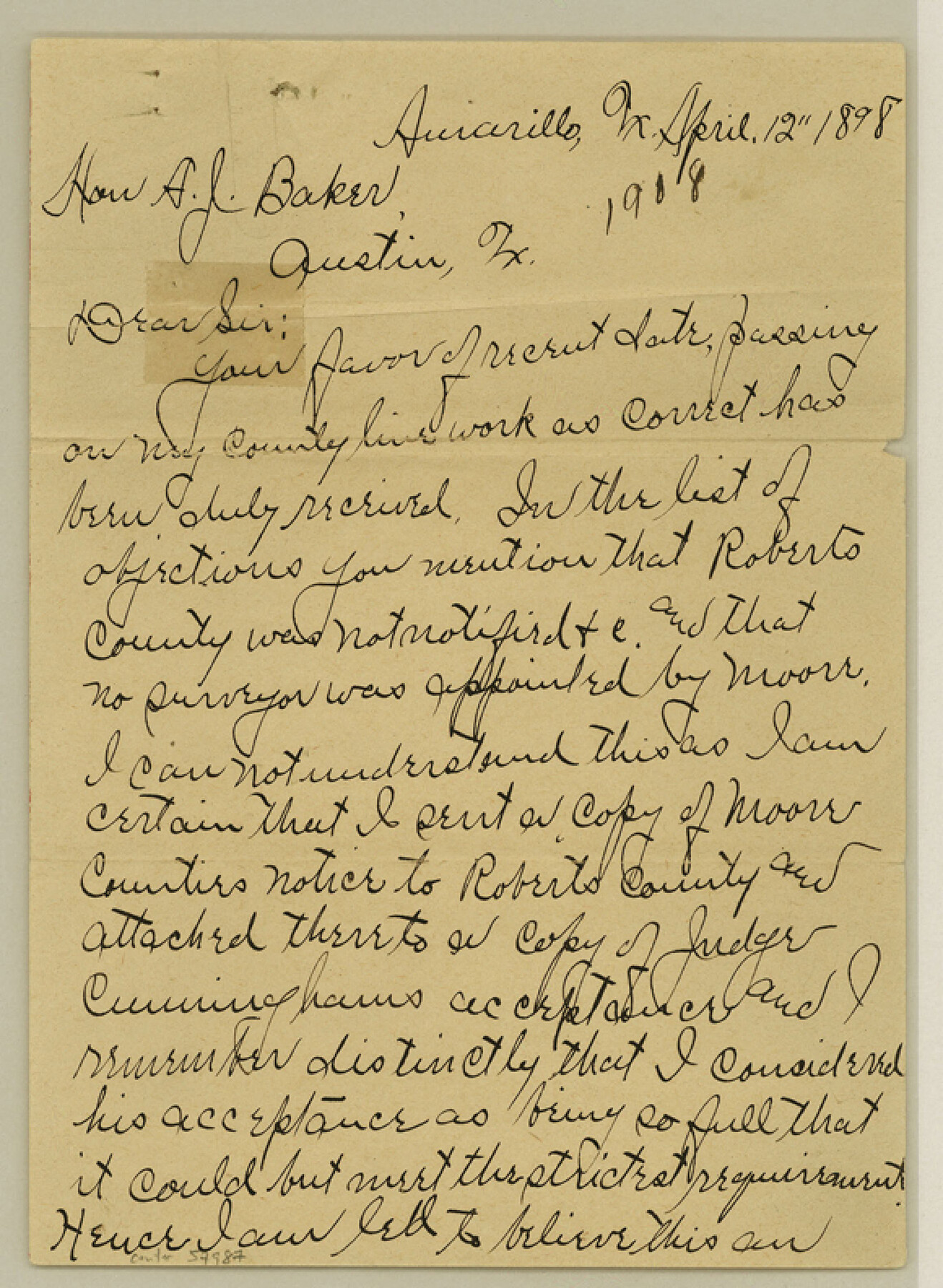
Potter County Boundary File 3d
[Letter regarding Panhandle Counties surveys]
-
Map/Doc
57987
-
Collection
General Map Collection
-
Counties
Potter
-
Subjects
County Boundaries
-
Height x Width
7.9 x 5.8 inches
20.1 x 14.7 cm
Part of: General Map Collection
[Beaumont, Sour Lake and Western Ry. Right of Way and Alignment - Frisco]
![64110, [Beaumont, Sour Lake and Western Ry. Right of Way and Alignment - Frisco], General Map Collection](https://historictexasmaps.com/wmedia_w700/maps/64110.tif.jpg)
Print $20.00
- Digital $50.00
[Beaumont, Sour Lake and Western Ry. Right of Way and Alignment - Frisco]
1910
Size 20.2 x 46.3 inches
Map/Doc 64110
Terrell County Sketch File 25A

Print $20.00
- Digital $50.00
Terrell County Sketch File 25A
1890
Size 16.9 x 21.5 inches
Map/Doc 12424
Amistad International Reservoir on Rio Grande 94

Print $20.00
- Digital $50.00
Amistad International Reservoir on Rio Grande 94
1950
Size 28.6 x 41.0 inches
Map/Doc 75524
Presidio County Rolled Sketch 30

Print $40.00
- Digital $50.00
Presidio County Rolled Sketch 30
Size 40.8 x 84.9 inches
Map/Doc 9767
Williamson County Rolled Sketch 5

Print $20.00
- Digital $50.00
Williamson County Rolled Sketch 5
1940
Size 23.7 x 34.5 inches
Map/Doc 8263
Duval County Sketch File 68

Print $20.00
- Digital $50.00
Duval County Sketch File 68
Size 23.9 x 19.6 inches
Map/Doc 11407
Cameron County Rolled Sketch Z2

Print $20.00
- Digital $50.00
Cameron County Rolled Sketch Z2
1937
Size 23.7 x 40.9 inches
Map/Doc 5402
[Maps of surveys in Reeves & Culberson Cos]
![61140, [Maps of surveys in Reeves & Culberson Cos], General Map Collection](https://historictexasmaps.com/wmedia_w700/maps/61140.tif.jpg)
Print $20.00
- Digital $50.00
[Maps of surveys in Reeves & Culberson Cos]
1937
Size 30.6 x 24.9 inches
Map/Doc 61140
Map of San Marcos

Print $20.00
- Digital $50.00
Map of San Marcos
1942
Size 27.4 x 21.6 inches
Map/Doc 2211
Brewster County Sketch File N-24

Print $40.00
- Digital $50.00
Brewster County Sketch File N-24
Size 23.9 x 16.4 inches
Map/Doc 10970
San Jacinto River, Water Sheds of the San Jacinto River and Buffalo Bayou

Print $4.00
- Digital $50.00
San Jacinto River, Water Sheds of the San Jacinto River and Buffalo Bayou
Size 28.8 x 20.0 inches
Map/Doc 65149

You may also like
Wichita County Working Sketch 14

Print $20.00
- Digital $50.00
Wichita County Working Sketch 14
1922
Size 20.8 x 42.1 inches
Map/Doc 72524
[H. & G. N. Block 4]
![90268, [H. & G. N. Block 4], Twichell Survey Records](https://historictexasmaps.com/wmedia_w700/maps/90268-1.tif.jpg)
Print $20.00
- Digital $50.00
[H. & G. N. Block 4]
1887
Size 22.2 x 19.6 inches
Map/Doc 90268
Brewster County Working Sketch 91

Print $40.00
- Digital $50.00
Brewster County Working Sketch 91
1975
Size 65.7 x 43.6 inches
Map/Doc 67691
Bird's Eye View of Victoria

Print $20.00
Bird's Eye View of Victoria
1873
Size 24.6 x 28.9 inches
Map/Doc 89210
Trinity River, Reynard Sheet

Print $20.00
- Digital $50.00
Trinity River, Reynard Sheet
1925
Size 42.3 x 45.3 inches
Map/Doc 65181
Hutchinson County Working Sketch 35

Print $20.00
- Digital $50.00
Hutchinson County Working Sketch 35
1978
Size 27.0 x 22.3 inches
Map/Doc 66395
Coast of Texas Between Brazos River and Matagorda Bay

Print $40.00
- Digital $50.00
Coast of Texas Between Brazos River and Matagorda Bay
1853
Size 32.6 x 72.1 inches
Map/Doc 69977
Culberson County Rolled Sketch 43A

Print $20.00
- Digital $50.00
Culberson County Rolled Sketch 43A
1947
Size 21.7 x 37.2 inches
Map/Doc 5665
[Map of Townsite of Swearingen, Cottle County, Texas]
![4465, [Map of Townsite of Swearingen, Cottle County, Texas], Maddox Collection](https://historictexasmaps.com/wmedia_w700/maps/4465.tif.jpg)
Print $20.00
- Digital $50.00
[Map of Townsite of Swearingen, Cottle County, Texas]
Size 28.8 x 17.8 inches
Map/Doc 4465
Bexar County Sketch File X

Print $4.00
- Digital $50.00
Bexar County Sketch File X
1878
Size 8.0 x 10.5 inches
Map/Doc 14463
Americae Nova Descriptio

Print $20.00
- Digital $50.00
Americae Nova Descriptio
1652
Size 19.7 x 23.5 inches
Map/Doc 95370
Tom Green County Rolled Sketch 27

Print $20.00
- Digital $50.00
Tom Green County Rolled Sketch 27
Size 36.1 x 45.4 inches
Map/Doc 10008